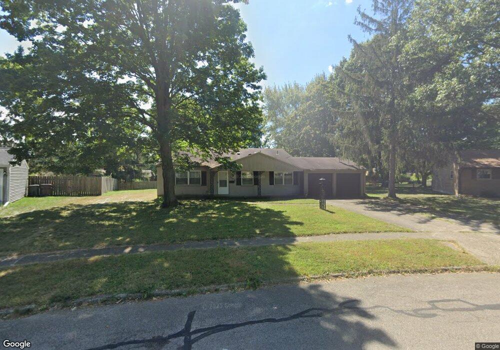
2100 Carol Pkwy Dayton, OH 45440
Estimated Value: $257,299 - $284,000
3
Beds
2
Baths
1,189
Sq Ft
$226/Sq Ft
Est. Value
About This Home
This home is located at 2100 Carol Pkwy, Dayton, OH 45440 and is currently estimated at $268,575, approximately $225 per square foot. 2100 Carol Pkwy is a home located in Montgomery County with nearby schools including John F. Kennedy Elementary School, Kettering Middle School, and Kettering Fairmont High School.
Ownership History
Date
Name
Owned For
Owner Type
Purchase Details
Closed on
Mar 4, 2022
Sold by
David Bennett F
Bought by
Fig 20 Llc and Sec Pty
Current Estimated Value
Purchase Details
Closed on
Jul 23, 2013
Sold by
Bennett David F and Smith Marcy S
Bought by
Bennett Jeffrey P
Purchase Details
Closed on
Mar 27, 2013
Sold by
Estate Of Paul D Bennett
Bought by
Bennett David and Smith Marcy A
Purchase Details
Closed on
Sep 3, 2002
Sold by
Bennett Paul D and Bennett Patricia J
Bought by
Bennett Paul D and Bennett Patricia J
Create a Home Valuation Report for This Property
The Home Valuation Report is an in-depth analysis detailing your home's value as well as a comparison with similar homes in the area
Home Values in the Area
Average Home Value in this Area
Purchase History
| Date | Buyer | Sale Price | Title Company |
|---|---|---|---|
| Fig 20 Llc | $10,240 | None Listed On Document | |
| Bennett Jeffrey P | -- | None Available | |
| Bennett David | -- | None Available | |
| Bennett Paul D | -- | -- |
Source: Public Records
Tax History Compared to Growth
Tax History
| Year | Tax Paid | Tax Assessment Tax Assessment Total Assessment is a certain percentage of the fair market value that is determined by local assessors to be the total taxable value of land and additions on the property. | Land | Improvement |
|---|---|---|---|---|
| 2024 | $4,601 | $72,680 | $17,700 | $54,980 |
| 2023 | $4,601 | $72,680 | $17,700 | $54,980 |
| 2022 | $4,330 | $54,110 | $13,210 | $40,900 |
| 2021 | $4,011 | $54,110 | $13,210 | $40,900 |
| 2020 | $4,023 | $54,110 | $13,210 | $40,900 |
| 2019 | $3,877 | $46,100 | $12,030 | $34,070 |
| 2018 | $3,898 | $46,100 | $12,030 | $34,070 |
| 2017 | $3,598 | $46,100 | $12,030 | $34,070 |
| 2016 | $3,363 | $40,470 | $12,030 | $28,440 |
| 2015 | $3,217 | $40,470 | $12,030 | $28,440 |
| 2014 | $3,217 | $40,470 | $12,030 | $28,440 |
| 2012 | -- | $41,780 | $12,010 | $29,770 |
Source: Public Records
Map
Nearby Homes
- 1968 Carol Pkwy
- 2217 Westlawn Dr
- 2169 Broadbent Way
- 4508 Rean Meadow Dr
- 2313 Glenheath Dr
- 2184 Broadbent Way
- 5195 Bigger Rd
- 2405 Westlawn Dr
- 2386 E Rahn Rd
- 2360 E Rahn Rd
- 4533 Drayton Ct
- 2318 E Rahn Rd
- 4824 Rean Meadow Dr
- 4370 Wilmington Pike
- 4464 Woodner Dr
- 2648 Parklawn Dr
- 5267 Newell Cir
- 5335 Glendon Ln
- 2021 Stayman Dr
- 5274 Millcreek Rd
- 2100 Carol Pkwy
- 1992 Carol Pkwy
- 2108 Carol Pkwy
- 2089 Westlawn Dr
- 2101 Westlawn Dr
- 2109 Westlawn Dr
- 2081 Westlawn Dr
- 1984 Carol Pkwy
- 2101 Carol Pkwy
- 2116 Carol Pkwy
- 2117 Westlawn Dr
- 2073 Westlawn Dr
- 4826 Ridgebury Dr
- 4800 Ridgebury Dr
- 2115 Carol Pkwy
- 1976 Carol Pkwy
- 4794 Ridgebury Dr
- 4851 Bigger Rd
- 4842 Ridgebury Dr
- 4889 Bigger Rd