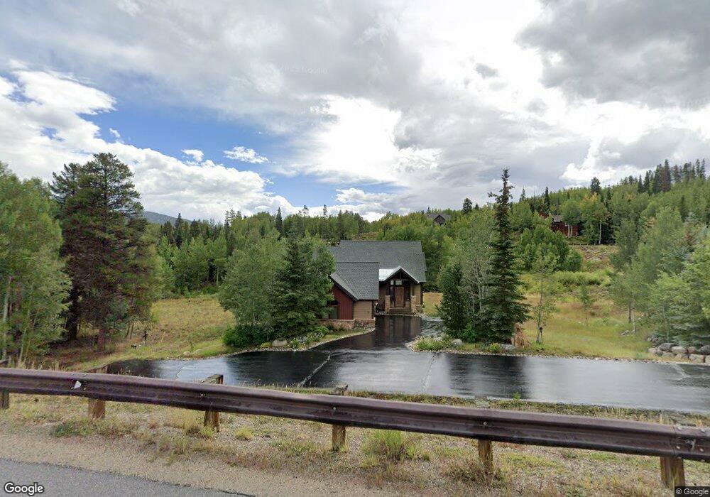
2100 Currant Way Silverthorne, CO 80498
Estimated Value: $2,357,245 - $2,835,000
4
Beds
4
Baths
1,728
Sq Ft
$1,530/Sq Ft
Est. Value
About This Home
This home is located at 2100 Currant Way, Silverthorne, CO 80498 and is currently estimated at $2,643,811, approximately $1,529 per square foot. 2100 Currant Way is a home with nearby schools including Silverthorne Elementary School, Summit Middle School, and Summit High School.
Ownership History
Date
Name
Owned For
Owner Type
Purchase Details
Closed on
Sep 1, 2023
Sold by
Johnstone David T and Johnstone Phyllis A
Bought by
Dpj Family Trust
Current Estimated Value
Purchase Details
Closed on
Oct 16, 2006
Sold by
Aspen Meadow Construction Company
Bought by
Johnstone David T and Johnstone Phyllis A
Home Financials for this Owner
Home Financials are based on the most recent Mortgage that was taken out on this home.
Original Mortgage
$860,000
Interest Rate
6.12%
Mortgage Type
New Conventional
Purchase Details
Closed on
Aug 22, 2005
Sold by
Mcintyre Janice M
Bought by
Aspen Meadow Construction Company
Purchase Details
Closed on
Jan 10, 2005
Sold by
Blue River Land Company Llc
Bought by
Mcintyre Janice M
Create a Home Valuation Report for This Property
The Home Valuation Report is an in-depth analysis detailing your home's value as well as a comparison with similar homes in the area
Home Values in the Area
Average Home Value in this Area
Purchase History
| Date | Buyer | Sale Price | Title Company |
|---|---|---|---|
| Dpj Family Trust | -- | None Listed On Document | |
| Johnstone David T | $1,075,000 | None Available | |
| Aspen Meadow Construction Company | -- | None Available | |
| Mcintyre Janice M | $195,000 | Land Title Guarantee Company |
Source: Public Records
Mortgage History
| Date | Status | Borrower | Loan Amount |
|---|---|---|---|
| Previous Owner | Johnstone David T | $860,000 |
Source: Public Records
Tax History Compared to Growth
Tax History
| Year | Tax Paid | Tax Assessment Tax Assessment Total Assessment is a certain percentage of the fair market value that is determined by local assessors to be the total taxable value of land and additions on the property. | Land | Improvement |
|---|---|---|---|---|
| 2024 | $7,384 | $140,372 | -- | -- |
| 2023 | $7,384 | $136,687 | $0 | $0 |
| 2022 | $5,725 | $100,198 | $0 | $0 |
| 2021 | $5,775 | $103,082 | $0 | $0 |
| 2020 | $4,782 | $91,183 | $0 | $0 |
| 2019 | $4,716 | $91,183 | $0 | $0 |
| 2018 | $5,104 | $89,340 | $0 | $0 |
| 2017 | $5,706 | $89,340 | $0 | $0 |
| 2016 | $5,064 | $78,409 | $0 | $0 |
| 2015 | $4,941 | $78,409 | $0 | $0 |
| 2014 | $4,804 | $75,472 | $0 | $0 |
| 2013 | -- | $75,472 | $0 | $0 |
Source: Public Records
Map
Nearby Homes
- 170 Arnica Ln
- 1525 Golden Eagle Rd
- 313 Raven Golf Ln
- 190 Easy Bend Trail
- 490 Two Cabins Dr
- 329 Raven Golf Ln
- 304 Raven Golf Ln
- 30a County Road 1293 Unit 30A
- 330 High Park Ct
- 440 Two Cabins Dr
- 2911 Ninth Green Ct
- 230 Game Trail Rd
- 245 Easy Bend Trail
- 210 Game Trail Rd
- 180 Two Cabins Dr
- 149 Game Trail Rd
- 240 Two Cabins Dr
- 125 Two Cabins Dr
- 115 Game Trail Rd
- 43 Maverick Way
- 2080 Currant Way
- 2060 Currant Way
- 2140 Hunter Knob Rd
- 2180 Currant Way
- 2045 Currant Way
- 2050 Currant Way
- 2105 Currant Way
- 2160 Currant Way
- 1815 Golden Eagle Rd
- 2200 Currant Way
- 2030 Currant Way
- 2215 Currant Way
- 1795 Golden Eagle Rd
- 285 Arnica Ln
- 2255 Currant Way
- 255 Arnica Ln
- 2530 Hunter's Knob Rd
- 1790 Golden Eagle Rd
- 1765 Golden Eagle Rd
- 2555 Hunter Knob Rd