Estimated Value: $105,458 - $161,000
2
Beds
1
Bath
1,274
Sq Ft
$99/Sq Ft
Est. Value
About This Home
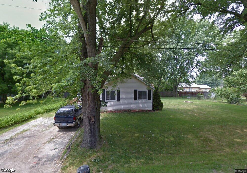
This home is located at 2100 Pound Dr, Flint, MI 48532 and is currently estimated at $125,865, approximately $98 per square foot. 2100 Pound Dr is a home located in Genesee County with nearby schools including Carman-Ainsworth High School, Genesee STEM Academy, and St. Paul Lutheran School.
Ownership History
Date
Name
Owned For
Owner Type
Purchase Details
Closed on
May 24, 2007
Sold by
Dellinger Richard A
Bought by
Arter Mary Allison
Current Estimated Value
Purchase Details
Closed on
Mar 14, 2007
Sold by
Dellinger Richard A
Bought by
The Federal National Mortgage Assn
Purchase Details
Closed on
Oct 27, 2004
Sold by
Chase Manhattan Mortgage Corp
Bought by
Hud
Purchase Details
Closed on
Dec 3, 2003
Sold by
Parker Michael and Parker Kellie N
Bought by
Chase Manhattan Mortgage Co
Create a Home Valuation Report for This Property
The Home Valuation Report is an in-depth analysis detailing your home's value as well as a comparison with similar homes in the area
Home Values in the Area
Average Home Value in this Area
Purchase History
| Date | Buyer | Sale Price | Title Company |
|---|---|---|---|
| Arter Mary Allison | $71,000 | Sargents Title Company | |
| The Federal National Mortgage Assn | $60,660 | None Available | |
| Hud | -- | -- | |
| Chase Manhattan Mortgage Co | $86,038 | -- |
Source: Public Records
Tax History
| Year | Tax Paid | Tax Assessment Tax Assessment Total Assessment is a certain percentage of the fair market value that is determined by local assessors to be the total taxable value of land and additions on the property. | Land | Improvement |
|---|---|---|---|---|
| 2025 | $1,116 | $48,300 | $0 | $0 |
| 2024 | $518 | $42,300 | $0 | $0 |
| 2023 | $495 | $39,400 | $0 | $0 |
| 2022 | $537 | $29,100 | $0 | $0 |
| 2021 | $985 | $25,000 | $0 | $0 |
| 2020 | $444 | $23,700 | $0 | $0 |
| 2019 | $438 | $21,300 | $0 | $0 |
| 2018 | $911 | $20,800 | $0 | $0 |
| 2017 | $883 | $20,800 | $0 | $0 |
| 2016 | $906 | $20,600 | $0 | $0 |
| 2015 | $736 | $19,000 | $0 | $0 |
| 2014 | $437 | $18,300 | $0 | $0 |
| 2012 | -- | $21,600 | $21,600 | $0 |
Source: Public Records
Map
Nearby Homes
- 2033 Eberly Rd
- 18.41 Taft Rd
- 1512 Crescent Lane Dr Lot#46
- 3277 Whitney Ave
- VL Clairmont St
- 10 Acres T A Mansour Blvd
- 3365 Ridgecliffe Dr
- 3349 Ridgecliffe Dr
- 4199 Sheraton Dr
- 4474 Corunna Rd
- 3320 Timberview St
- 4480 Corunna Rd
- 3915 Augusta St
- 3493 Ridgecliffe Dr
- 3918 Larchmont St
- 1455 S Linden Rd
- 3825 Arlene Ave
- 3288 Tall Oaks Ct
- 0 Charter Dr Unit 50153638
- 3805 Brown St
- 2100 Pound Dr
- 2095 Lambden Rd
- 2086 Pound Dr
- 2105 Lambden Rd
- 2087 Lambden Rd
- 2110 Pound Dr
- 2095 Pound Dr
- 2105 Pound Dr
- 2074 Pound Dr
- 2125 Lambden Rd
- 2109 Lambden Rd
- 2077 Lambden Rd
- 2117 Pound Dr
- 2098 Lambden Rd
- 2094 Lambden Rd
- 2104 Lambden Rd
- 2077 Pound Dr
- 2084 Lambden Rd
- 2110 Lambden Rd
- 4041 Brown St
Your Personal Tour Guide
Ask me questions while you tour the home.