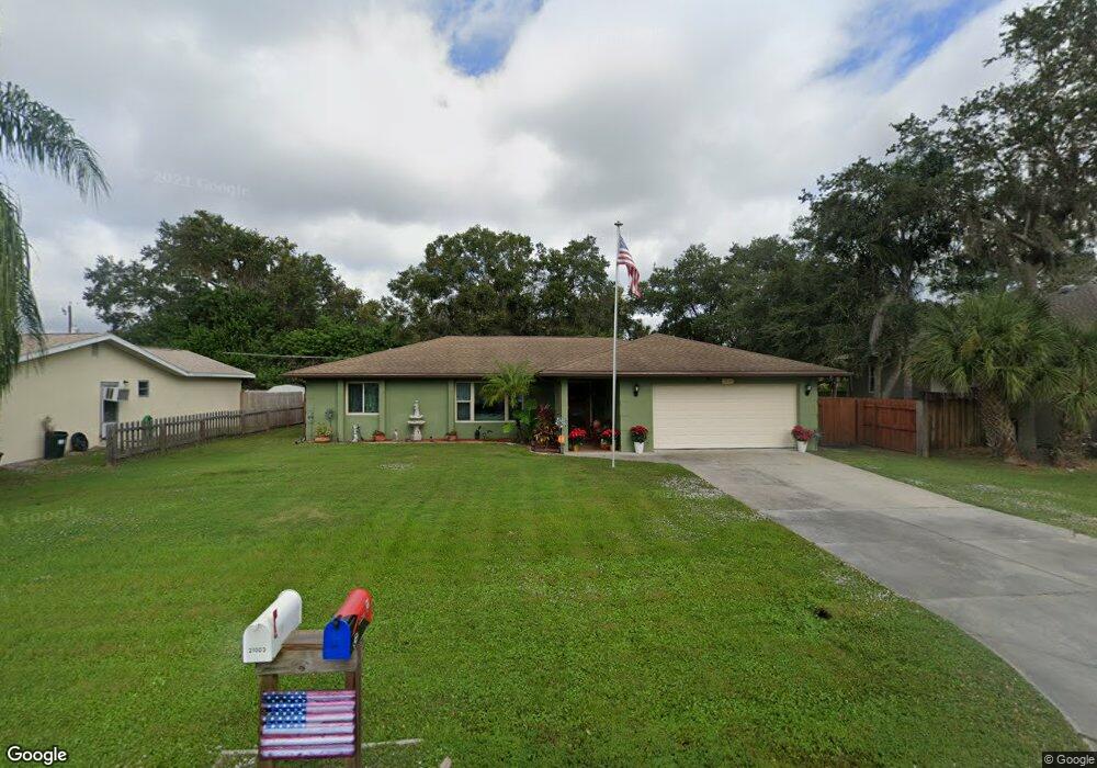
21004 Exmore Ave Port Charlotte, FL 33952
Estimated Value: $205,000 - $300,000
2
Beds
2
Baths
1,489
Sq Ft
$169/Sq Ft
Est. Value
About This Home
This home is located at 21004 Exmore Ave, Port Charlotte, FL 33952 and is currently estimated at $251,838, approximately $169 per square foot. 21004 Exmore Ave is a home located in Charlotte County with nearby schools including Neil Armstrong Elementary School, Murdock Middle School, and Port Charlotte High School.
Ownership History
Date
Name
Owned For
Owner Type
Purchase Details
Closed on
Feb 3, 2015
Sold by
Wehunt Teresa
Bought by
Wehunt Teresa and Welby Kristopher D
Current Estimated Value
Purchase Details
Closed on
Feb 25, 2013
Sold by
Odriscoll Philip and Odriscoll Philip Edward
Bought by
Wehunt Teresa
Purchase Details
Closed on
May 17, 2012
Sold by
Odriscoll Angela
Bought by
Odriscoll Philip
Purchase Details
Closed on
Jan 23, 2008
Sold by
Pearce Linda Odriscoll
Bought by
Odriscoll Philip Edward
Purchase Details
Closed on
Apr 15, 2002
Sold by
Odriscoll Norah
Bought by
Odriscoll Odriscoll Norah Norah and Odriscoll Pearce Linda
Create a Home Valuation Report for This Property
The Home Valuation Report is an in-depth analysis detailing your home's value as well as a comparison with similar homes in the area
Home Values in the Area
Average Home Value in this Area
Purchase History
| Date | Buyer | Sale Price | Title Company |
|---|---|---|---|
| Wehunt Teresa | -- | None Available | |
| Wehunt Teresa | -- | None Available | |
| Wehunt Teresa | $70,000 | Florida Abstract & Security | |
| Odriscoll Philip | -- | Attorney | |
| Odriscoll Philip Edward | -- | Attorney | |
| Odriscoll Odriscoll Norah Norah | -- | -- |
Source: Public Records
Tax History Compared to Growth
Tax History
| Year | Tax Paid | Tax Assessment Tax Assessment Total Assessment is a certain percentage of the fair market value that is determined by local assessors to be the total taxable value of land and additions on the property. | Land | Improvement |
|---|---|---|---|---|
| 2024 | $1,475 | $95,016 | -- | -- |
| 2023 | $1,475 | $92,249 | $0 | $0 |
| 2022 | $1,468 | $89,562 | $0 | $0 |
| 2021 | $1,447 | $86,953 | $0 | $0 |
| 2020 | $1,403 | $85,752 | $0 | $0 |
| 2019 | $1,319 | $83,824 | $0 | $0 |
| 2018 | $1,198 | $82,261 | $0 | $0 |
| 2017 | $1,178 | $80,569 | $0 | $0 |
| 2016 | $1,163 | $78,912 | $0 | $0 |
| 2015 | $1,146 | $78,363 | $0 | $0 |
| 2014 | $1,121 | $77,741 | $0 | $0 |
Source: Public Records
Map
Nearby Homes
- 20995 Cornell Ave
- 21059 Cascade Ave
- 21051 Cascade Ave
- 21068 Exmore Ave
- 1394 Viscaya Dr
- 1418 Viscaya
- 1402 Viscaya Dr
- 1409 Yorkshire St
- 1358 Fargo St
- 1301 Yates St
- 1381 Fargo St
- 21019 Malden Ave
- 1525 Hinton St
- 1490 Yorkshire St
- 1565 Dorchester St
- 20390 Lorenzo Ave
- 1469 Proper St
- 1505 Kenmore St
- 1573 Faraday St
- 20352 Astoria Ave
- 20996 Exmore Ave
- 21012 Exmore Ave
- 21011 Cornell Ave
- 20988 Exmore Ave
- 21003 Exmore Ave
- 21011 Exmore Ave
- 20995 Exmore Ave
- 21019 Cornell Ave
- 20987 Cornell Ave
- 21028 Avenue
- 21019 Exmore Ave
- 20987 Exmore Ave
- 21028 Exmore Ave
- 20980 Exmore Ave
- 21027 Cornell Ave
- 20979 Cornell Ave
- 21004 Kearney Ave
- 21004 Cornell Ave
- 21012 Cornell Ave
- 20996 Cornell Ave