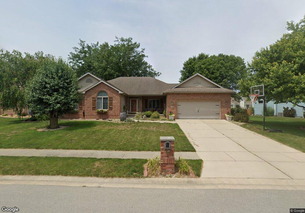
2101 Palo Alto Dr Springfield, IL 62711
Estimated Value: $307,040 - $356,000
--
Bed
--
Bath
--
Sq Ft
0.3
Acres
About This Home
This home is located at 2101 Palo Alto Dr, Springfield, IL 62711 and is currently estimated at $332,010. 2101 Palo Alto Dr is a home located in Sangamon County with nearby schools including Lindsay School, U.S. Grant Middle School, and Springfield High School.
Ownership History
Date
Name
Owned For
Owner Type
Purchase Details
Closed on
Mar 11, 2021
Sold by
Eugene Browning Brian
Bought by
Browning Elizabeth Marie
Current Estimated Value
Home Financials for this Owner
Home Financials are based on the most recent Mortgage that was taken out on this home.
Original Mortgage
$109,460
Outstanding Balance
$98,123
Interest Rate
2.7%
Mortgage Type
New Conventional
Estimated Equity
$233,887
Purchase Details
Closed on
Feb 28, 2001
Purchase Details
Closed on
Apr 19, 1996
Purchase Details
Closed on
Dec 7, 1995
Create a Home Valuation Report for This Property
The Home Valuation Report is an in-depth analysis detailing your home's value as well as a comparison with similar homes in the area
Home Values in the Area
Average Home Value in this Area
Purchase History
| Date | Buyer | Sale Price | Title Company |
|---|---|---|---|
| Browning Elizabeth Marie | -- | -- | |
| -- | $185,000 | -- | |
| -- | $170,400 | -- | |
| -- | $28,300 | -- |
Source: Public Records
Mortgage History
| Date | Status | Borrower | Loan Amount |
|---|---|---|---|
| Open | Browning Elizabeth Marie | $109,460 |
Source: Public Records
Tax History Compared to Growth
Tax History
| Year | Tax Paid | Tax Assessment Tax Assessment Total Assessment is a certain percentage of the fair market value that is determined by local assessors to be the total taxable value of land and additions on the property. | Land | Improvement |
|---|---|---|---|---|
| 2024 | $7,250 | $93,613 | $14,887 | $78,726 |
| 2023 | $6,924 | $85,507 | $13,598 | $71,909 |
| 2022 | $6,588 | $80,632 | $12,898 | $67,734 |
| 2021 | $6,350 | $77,613 | $12,415 | $65,198 |
| 2020 | $6,224 | $77,730 | $12,434 | $65,296 |
| 2019 | $6,108 | $77,459 | $12,391 | $65,068 |
| 2018 | $5,514 | $72,226 | $12,331 | $59,895 |
| 2017 | $5,394 | $71,293 | $12,172 | $59,121 |
| 2016 | $5,281 | $70,253 | $11,994 | $58,259 |
| 2015 | $5,224 | $69,413 | $11,851 | $57,562 |
| 2014 | $5,162 | $68,964 | $11,774 | $57,190 |
| 2013 | $5,047 | $69,206 | $11,775 | $57,431 |
Source: Public Records
Map
Nearby Homes
- LOT 54 Chestnut Dr
- 4817 Greenbriar Dr
- 1412 Winston Dr
- 4605 Bellevue Dr
- 2401 Asheville Dr
- 0 Lenhart Rd
- 6013 Hedley Rd
- 5904 Hedley Rd
- 2862 Reseda Rd Unit LOT16
- 4113 Gaskell Dr
- 5225 Jade Ln Unit LOT19
- 5301 Jade Ln Unit LOT20
- 5220 Jade Ln Unit LOT39
- 5224 Jade Ln Unit LOT38
- 5309 Jade Ln Unit LOT22
- 5300 Jade Ln Unit LOT37
- 2871 Reseda Rd Unit LOT40
- 5313 Jade Ln Unit LOT23
- 5304 Jade Ln Unit LOT36
- 5401 Jade Ln Unit LOT24
- 2105 Palo Alto Dr
- 2005 Palo Alto Dr
- 2104 Palo Alto Dr
- 2201 Palo Alto Dr
- 2100 Palo Alto Dr
- 4664 Barrington Dr
- 4668 Barrington Dr
- 2008 Palo Alto Dr
- 4660 Barrington Dr
- 2104 Disar Dr
- 4672 Barrington Dr
- 2200 Palo Alto Dr
- 2205 Palo Alto Dr
- 2108 Disar Dr
- 2004 Palo Alto Dr
- 2112 Disar Dr
- 2109 Burgess Dr
- 2000 Palo Alto Dr
- 2113 Burgess Dr
- 2204 Palo Alto Dr