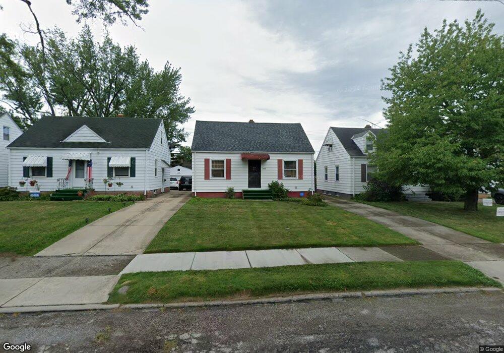
21012 Watson Rd Maple Heights, OH 44137
Estimated Value: $92,000 - $132,000
2
Beds
1
Bath
720
Sq Ft
$150/Sq Ft
Est. Value
About This Home
This home is located at 21012 Watson Rd, Maple Heights, OH 44137 and is currently estimated at $107,646, approximately $149 per square foot. 21012 Watson Rd is a home located in Cuyahoga County with nearby schools including Abraham Lincoln Elementary School, Rockside/ J.F. Kennedy School, and Barack Obama School.
Ownership History
Date
Name
Owned For
Owner Type
Purchase Details
Closed on
May 25, 2007
Sold by
Bowles Douglas W and Bowles Kitty A
Bought by
Bowles Douglas W and Bowles Kitty A
Current Estimated Value
Home Financials for this Owner
Home Financials are based on the most recent Mortgage that was taken out on this home.
Original Mortgage
$103,500
Outstanding Balance
$63,127
Interest Rate
6.22%
Mortgage Type
New Conventional
Estimated Equity
$44,519
Purchase Details
Closed on
Apr 24, 2005
Sold by
Martimus Lafayette O
Bought by
Bowles Douglas W
Purchase Details
Closed on
May 28, 1998
Sold by
Santelli Rinaldo and Santelli Mary
Bought by
Martemus Jr Lafayette O
Home Financials for this Owner
Home Financials are based on the most recent Mortgage that was taken out on this home.
Original Mortgage
$66,800
Interest Rate
7.27%
Mortgage Type
VA
Purchase Details
Closed on
Jan 1, 1975
Bought by
Santelli Rinaldo
Create a Home Valuation Report for This Property
The Home Valuation Report is an in-depth analysis detailing your home's value as well as a comparison with similar homes in the area
Home Values in the Area
Average Home Value in this Area
Purchase History
| Date | Buyer | Sale Price | Title Company |
|---|---|---|---|
| Bowles Douglas W | -- | Tower City | |
| Bowles Douglas W | -- | -- | |
| Martemus Jr Lafayette O | $65,500 | Midland Title Security Inc | |
| Santelli Rinaldo | -- | -- |
Source: Public Records
Mortgage History
| Date | Status | Borrower | Loan Amount |
|---|---|---|---|
| Open | Bowles Douglas W | $103,500 | |
| Previous Owner | Martemus Jr Lafayette O | $66,800 |
Source: Public Records
Tax History
| Year | Tax Paid | Tax Assessment Tax Assessment Total Assessment is a certain percentage of the fair market value that is determined by local assessors to be the total taxable value of land and additions on the property. | Land | Improvement |
|---|---|---|---|---|
| 2024 | $2,864 | $30,450 | $6,965 | $23,485 |
| 2023 | $1,906 | $16,630 | $4,200 | $12,430 |
| 2022 | $1,900 | $16,630 | $4,200 | $12,430 |
| 2021 | $2,021 | $16,630 | $4,200 | $12,430 |
| 2020 | $1,740 | $12,600 | $3,190 | $9,420 |
| 2019 | $1,729 | $36,000 | $9,100 | $26,900 |
| 2018 | $1,628 | $12,600 | $3,190 | $9,420 |
| 2017 | $1,668 | $11,870 | $2,980 | $8,890 |
| 2016 | $1,613 | $11,870 | $2,980 | $8,890 |
| 2015 | $1,600 | $11,870 | $2,980 | $8,890 |
| 2014 | $1,600 | $13,030 | $3,260 | $9,770 |
Source: Public Records
Map
Nearby Homes
- 21207 Franklin Rd
- 20715 Watson Rd
- 21202 Hillgrove Ave
- 20705 Hansen Rd
- 20905 Clare Ave
- 21600 Franklin Rd
- 20600 Watson Rd
- 20517 Raymond St
- 20806 Clare Ave
- 5147 Warrensville Center Rd
- 21202 Gardenview Dr
- 21860 Louis Rd
- 21607 Libby Rd
- 19931 Raymond St
- 0 Miles Rd Unit 5188561
- 19520 Maple Heights Blvd
- 5165 Camden Rd
- 19289 Stafford Ave
- 22711 Vera St
- 5194 Homewood Ave
- 21016 Watson Rd
- 21008 Watson Rd
- 21004 Watson Rd
- 21104 Watson Rd
- 21000 Watson Rd
- 21011 Raymond St
- 21015 Raymond St
- 21007 Raymond St
- 21003 Raymond St
- 21019 Raymond St
- 20914 Watson Rd
- 21108 Watson Rd
- 21013 Watson Rd
- 21017 Watson Rd
- 20917 Raymond St
- 21009 Watson Rd
- 21101 Watson Rd
- 21005 Watson Rd
- 21112 Watson Rd
- 21105 Watson Rd
Your Personal Tour Guide
Ask me questions while you tour the home.