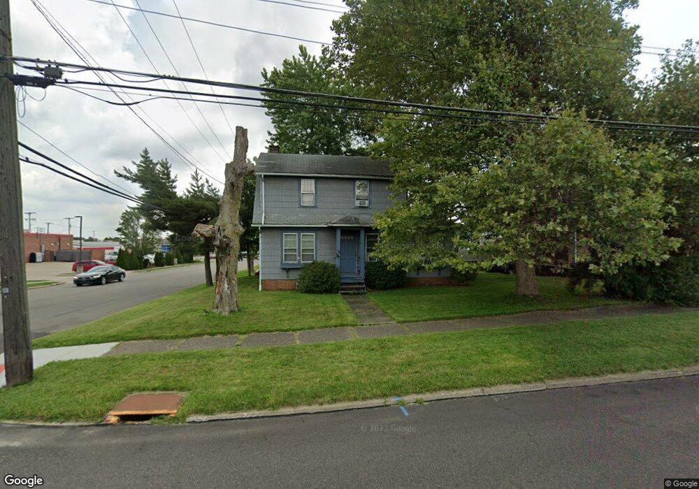
2104 Clark Ave Alliance, OH 44601
Estimated Value: $94,510 - $153,000
2
Beds
1
Bath
1,160
Sq Ft
$114/Sq Ft
Est. Value
About This Home
This home is located at 2104 Clark Ave, Alliance, OH 44601 and is currently estimated at $131,878, approximately $113 per square foot. 2104 Clark Ave is a home located in Stark County with nearby schools including Alliance Elementary School at Rockhill, Alliance Intermediate School at Northside, and Alliance Middle School.
Ownership History
Date
Name
Owned For
Owner Type
Purchase Details
Closed on
Apr 13, 2022
Sold by
Minor Ronald C and Minor Anna M
Bought by
Minor Rentals Llc
Current Estimated Value
Purchase Details
Closed on
Jun 6, 2001
Sold by
Fisher Jay C and Fisher Jodi P
Bought by
Minor Ronald C and Minor Anna M
Home Financials for this Owner
Home Financials are based on the most recent Mortgage that was taken out on this home.
Original Mortgage
$47,920
Interest Rate
7.18%
Mortgage Type
Purchase Money Mortgage
Purchase Details
Closed on
Jul 8, 1994
Sold by
White Mark A
Bought by
Fisher Jay C and Fisher Jodi
Home Financials for this Owner
Home Financials are based on the most recent Mortgage that was taken out on this home.
Original Mortgage
$32,300
Interest Rate
8.61%
Mortgage Type
New Conventional
Create a Home Valuation Report for This Property
The Home Valuation Report is an in-depth analysis detailing your home's value as well as a comparison with similar homes in the area
Home Values in the Area
Average Home Value in this Area
Purchase History
| Date | Buyer | Sale Price | Title Company |
|---|---|---|---|
| Minor Rentals Llc | -- | Geiger Teeple Robinson & Mcelw | |
| Minor Ronald C | -- | -- | |
| Fisher Jay C | $34,000 | -- |
Source: Public Records
Mortgage History
| Date | Status | Borrower | Loan Amount |
|---|---|---|---|
| Previous Owner | Minor Ronald C | $47,920 | |
| Previous Owner | Fisher Jay C | $32,300 |
Source: Public Records
Tax History Compared to Growth
Tax History
| Year | Tax Paid | Tax Assessment Tax Assessment Total Assessment is a certain percentage of the fair market value that is determined by local assessors to be the total taxable value of land and additions on the property. | Land | Improvement |
|---|---|---|---|---|
| 2025 | -- | $22,960 | $6,930 | $16,030 |
| 2024 | $2,203 | $22,960 | $6,930 | $16,030 |
| 2023 | $2,203 | $22,300 | $8,790 | $13,510 |
| 2022 | $924 | $22,300 | $8,790 | $13,510 |
| 2021 | $927 | $22,300 | $8,790 | $13,510 |
| 2020 | $839 | $18,870 | $7,630 | $11,240 |
| 2019 | $828 | $18,870 | $7,630 | $11,240 |
| 2018 | $832 | $18,870 | $7,630 | $11,240 |
| 2017 | $723 | $16,110 | $6,370 | $9,740 |
| 2016 | $783 | $17,300 | $6,370 | $10,930 |
| 2015 | $768 | $17,300 | $6,370 | $10,930 |
| 2014 | $662 | $14,190 | $5,220 | $8,970 |
| 2013 | $330 | $14,190 | $5,220 | $8,970 |
Source: Public Records
Map
Nearby Homes
- 112 E College St
- 317 E State St
- 2460 S Arch Ave
- 236 E Milton St
- 1475 Chatauqua Ct
- 2408 S Linden Ave
- 884 W College Rd
- 390 E College St
- 1515 S Rockhill Ave
- 2218 S Freedom Ave
- 1846 S Freedom Ave
- 2839 S Rockhill Ave
- 2376 S Seneca Ave
- 1437 S Linden Ave
- 555 E Milton St
- 1321 Parkway Blvd
- 1059 Oakwood Dr
- 3101 Ridgehill Ave
- 1136 Parkway Blvd
- 551 South St
- 2122 Clark Ave
- 2105 Miller Ave
- 2136 Clark Ave
- 2117 Miller Ave
- 2101 Clark Ave
- 2131 Miller Ave
- 2148 Clark Ave
- 2155 Clark Ave
- 2145 Miller Ave
- 330 W Chestnut St
- 2189 Clark Ave
- 2208 Clark Ave
- 2106 Miller Ave
- 2120 Miller Ave
- 2134 Miller Ave
- 2205 Miller Ave
- 2144 Miller Ave
- 2205 Clark Ave
- 2220 Clark Ave
- 2221 Miller Ave