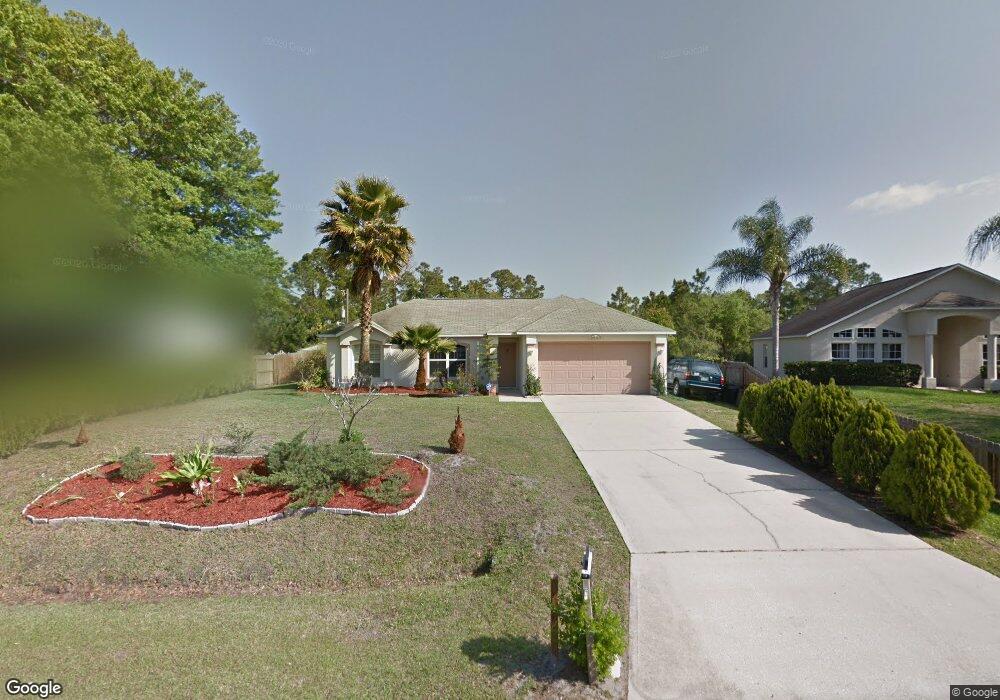
2107 Ramsdale Dr SE Palm Bay, FL 32909
Estimated Value: $287,842 - $316,000
4
Beds
2
Baths
1,848
Sq Ft
$166/Sq Ft
Est. Value
About This Home
This home is located at 2107 Ramsdale Dr SE, Palm Bay, FL 32909 and is currently estimated at $307,211, approximately $166 per square foot. 2107 Ramsdale Dr SE is a home located in Brevard County with nearby schools including Columbia Elementary School, Southwest Middle School, and Bayside High School.
Ownership History
Date
Name
Owned For
Owner Type
Purchase Details
Closed on
Nov 24, 1998
Sold by
Maronda Homes Inc Fl
Bought by
Gray Kathleen
Current Estimated Value
Home Financials for this Owner
Home Financials are based on the most recent Mortgage that was taken out on this home.
Original Mortgage
$77,063
Outstanding Balance
$17,355
Interest Rate
6.95%
Estimated Equity
$289,856
Purchase Details
Closed on
Jun 23, 1998
Sold by
Noyes Kenneth R and Noyes Lai Fu
Bought by
Maronda Homes Inc Fl
Create a Home Valuation Report for This Property
The Home Valuation Report is an in-depth analysis detailing your home's value as well as a comparison with similar homes in the area
Home Values in the Area
Average Home Value in this Area
Purchase History
| Date | Buyer | Sale Price | Title Company |
|---|---|---|---|
| Gray Kathleen | $77,200 | -- | |
| Maronda Homes Inc Fl | $4,500 | -- |
Source: Public Records
Mortgage History
| Date | Status | Borrower | Loan Amount |
|---|---|---|---|
| Open | Gray Kathleen | $77,063 |
Source: Public Records
Tax History Compared to Growth
Tax History
| Year | Tax Paid | Tax Assessment Tax Assessment Total Assessment is a certain percentage of the fair market value that is determined by local assessors to be the total taxable value of land and additions on the property. | Land | Improvement |
|---|---|---|---|---|
| 2025 | $845 | $84,910 | -- | -- |
| 2024 | $808 | $82,520 | -- | -- |
| 2023 | $808 | $80,120 | $0 | $0 |
| 2022 | $743 | $77,790 | $0 | $0 |
| 2021 | $736 | $75,530 | $0 | $0 |
| 2020 | $723 | $74,490 | $0 | $0 |
| 2019 | $883 | $72,820 | $0 | $0 |
| 2018 | $881 | $71,470 | $0 | $0 |
| 2017 | $912 | $70,000 | $0 | $0 |
| 2016 | $748 | $68,570 | $4,500 | $64,070 |
| 2015 | $765 | $68,100 | $3,500 | $64,600 |
| 2014 | $772 | $67,560 | $3,500 | $64,060 |
Source: Public Records
Map
Nearby Homes
- 2123 Ramsdale Dr SE
- 1229 Wakefield Rd SE
- 010/ 2379 Ramsey Rd SE
- 0 Ramsey Rd SE
- 2251 Ramrod Ln SE
- 2250 Ramrod Ln SE
- 2346 Ramsey Rd SE
- 2297 Wagonwheel Ave SE
- 2170 Randall Ave SE
- 2162 Randall Ave SE
- 1266 Ragen Rd SE
- 1368 Rabbit St SE
- 0 Walsh Ave SE Unit MFRTB8436838
- 2181 Wagonwheel Ave SE
- 1313 Rabbit St SE
- 1241 Rayfield St SE
- 2139 Randall Ave SE
- 1305 Rabbit St SE
- 1246 Tiffiny Ave
- 2188 Wagonwheel Ave SE
- 2091 Ramsdale Dr SE
- 2115 Ramsdale Dr SE
- 2083 Ramsdale Dr SE
- 2114 Ramsdale Dr SE
- 1222 Wakefield Rd SE
- 2075 Ramsdale Dr SE
- 2194 Watkins Rd SE
- 2131 Ramsdale Dr SE
- 2130 Ramsdale Dr SE
- 1238 Wakefield Rd SE
- 1206 Wakefield Rd SE
- 2201 Ramrod Ln SE
- 2220 Rambler Ln SE
- 2071 Ramsdale Dr SE
- 2239 Rambler Ln SE
- 2139 Ramsdale Dr SE
- 2195 Watkins Rd SE
- 2211 Ramrod Ln SE
- 1221 Wakefield Rd SE
- 2190 Watkins Rd SE