Estimated Value: $541,000 - $579,000
4
Beds
3
Baths
2,308
Sq Ft
$245/Sq Ft
Est. Value
About This Home
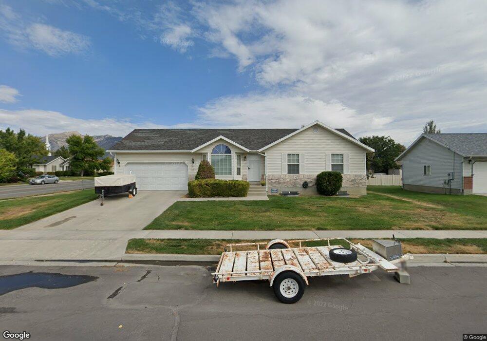
This home is located at 2108 N 1100 E, Lehi, UT 84043 and is currently estimated at $565,606, approximately $245 per square foot. 2108 N 1100 E is a home located in Utah County with nearby schools including Freedom Elementary School, Lehi Junior High School, and Skyridge High School.
Ownership History
Date
Name
Owned For
Owner Type
Purchase Details
Closed on
Oct 10, 2025
Sold by
Belnap Scott and Belnap Stacey
Bought by
Utah Sell Now Llc
Current Estimated Value
Home Financials for this Owner
Home Financials are based on the most recent Mortgage that was taken out on this home.
Original Mortgage
$307,257
Outstanding Balance
$306,429
Interest Rate
6.56%
Mortgage Type
New Conventional
Estimated Equity
$259,177
Purchase Details
Closed on
Jun 24, 2019
Sold by
Belnap Scott
Bought by
Belnap Scott and Belnap Stacey
Home Financials for this Owner
Home Financials are based on the most recent Mortgage that was taken out on this home.
Original Mortgage
$279,898
Interest Rate
4%
Mortgage Type
New Conventional
Purchase Details
Closed on
Jun 8, 2018
Sold by
Fish Brnat H and Fish Laurie M
Bought by
Belnap Scott and Belnap Stacey
Home Financials for this Owner
Home Financials are based on the most recent Mortgage that was taken out on this home.
Original Mortgage
$268,000
Interest Rate
4.5%
Mortgage Type
New Conventional
Purchase Details
Closed on
Jul 20, 2015
Sold by
Corkins Jennifer
Bought by
Fish Brant H and Fish Laurie M
Home Financials for this Owner
Home Financials are based on the most recent Mortgage that was taken out on this home.
Original Mortgage
$255,192
Interest Rate
4.37%
Mortgage Type
FHA
Purchase Details
Closed on
Dec 4, 2002
Sold by
Corkins Rudolph P
Bought by
Corkins Rudolph P and Corkins Lucille
Purchase Details
Closed on
Nov 14, 2002
Sold by
Thompson Brent and Thompson Korrin
Bought by
Corkins Rudolph P
Purchase Details
Closed on
Feb 16, 1999
Sold by
Patterson Construction Inc
Bought by
Thompson Brent and Thompson Korrin
Home Financials for this Owner
Home Financials are based on the most recent Mortgage that was taken out on this home.
Original Mortgage
$135,550
Interest Rate
6.77%
Create a Home Valuation Report for This Property
The Home Valuation Report is an in-depth analysis detailing your home's value as well as a comparison with similar homes in the area
Home Values in the Area
Average Home Value in this Area
Purchase History
| Date | Buyer | Sale Price | Title Company |
|---|---|---|---|
| Utah Sell Now Llc | -- | Title Guarantee | |
| Belnap Scott | -- | Title Guarantee | |
| Belnap Scott | -- | Title Guarantee | |
| Belnap Scott | -- | Title Guarantee | |
| Fish Brant H | -- | Nortwest Title Ins Age | |
| Corkins Rudolph P | -- | -- | |
| Corkins Rudolph P | -- | Sundance Title Insurance Ag | |
| Thompson Brent | -- | First American Title Co |
Source: Public Records
Mortgage History
| Date | Status | Borrower | Loan Amount |
|---|---|---|---|
| Open | Utah Sell Now Llc | $307,257 | |
| Previous Owner | Belnap Scott | $279,898 | |
| Previous Owner | Belnap Scott | $268,000 | |
| Previous Owner | Fish Brant H | $255,192 | |
| Previous Owner | Thompson Brent | $135,550 |
Source: Public Records
Tax History
| Year | Tax Paid | Tax Assessment Tax Assessment Total Assessment is a certain percentage of the fair market value that is determined by local assessors to be the total taxable value of land and additions on the property. | Land | Improvement |
|---|---|---|---|---|
| 2025 | $2,220 | $528,200 | $216,700 | $311,500 |
| 2024 | $2,220 | $259,765 | $0 | $0 |
| 2023 | $2,048 | $260,260 | $0 | $0 |
| 2022 | $2,301 | $283,415 | $0 | $0 |
| 2021 | $2,051 | $381,900 | $125,400 | $256,500 |
| 2020 | $1,933 | $355,800 | $116,100 | $239,700 |
| 2019 | $1,716 | $328,400 | $116,100 | $212,300 |
| 2018 | $1,675 | $303,000 | $111,100 | $191,900 |
| 2017 | $1,581 | $152,020 | $0 | $0 |
| 2016 | $1,570 | $140,140 | $0 | $0 |
| 2015 | $1,578 | $133,705 | $0 | $0 |
| 2014 | $1,428 | $120,230 | $0 | $0 |
Source: Public Records
Map
Nearby Homes
- 10365 N 6960 W
- 6756 W 10050 N
- 1370 N Cedar Hollow Blvd
- 9967 N 6670 W
- 1272 N Cedar Hollow Blvd
- 975 E 2850 N
- 4233 N 325 E Unit 1415
- 6576 W 9810 N
- 878 E 3050 N
- 9435 N Aspen Hollow Cir
- 1635 E 1060 N
- 1175 E 900 N
- 2139 N Banbury Ct
- 1602 E Center Pointe Dr
- 1610 E Center Pointe Dr
- 1618 E Center Pointe Dr
- 893 N 1580 E
- 3239 N 620 E
- 890 N Whipple Dr
- 3368 N 700 E
- 1150 Airport Dr
- 1119 Airport Dr
- 2109 N 1100 E
- 2078 N 1100 E
- 2105 N 1200 E
- 2085 N 1100 E
- 1147 E Airport Dr
- 1176 Airport Dr
- 1101 E Airport Dr
- 1101 E Airport Dr
- 2087 N 1200 E
- 2077 N 1100 E
- 1175 E Airport Dr
- 1085 E Airport Dr
- 1085 E Airport Dr
- 2075 N 1200 E
- 1064 E Airport Dr
- 1064 Airport Dr
- 2080 N 1100 E
- 2051 N 1100 E
Your Personal Tour Guide
Ask me questions while you tour the home.