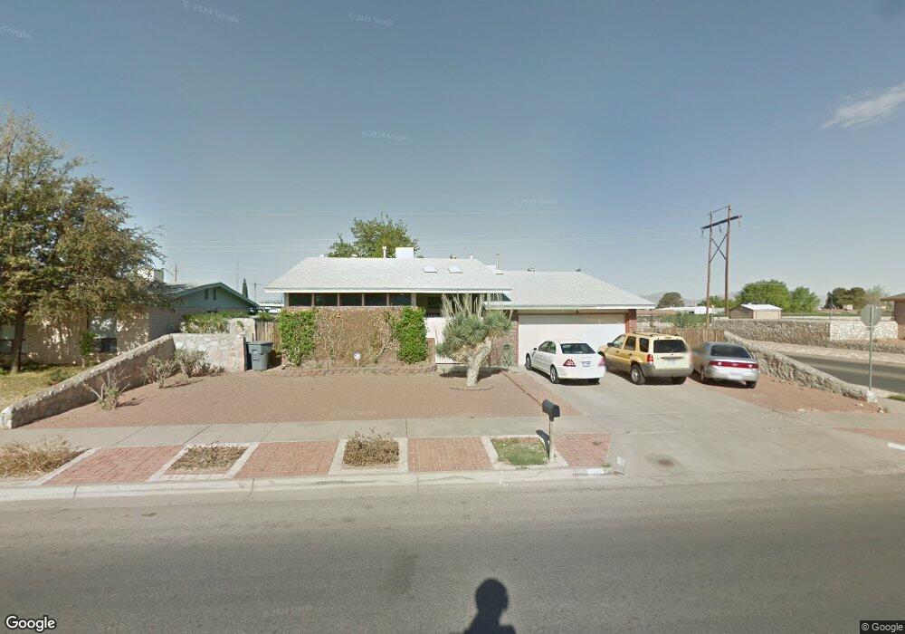
2109 Mermaid Dr El Paso, TX 79936
Glen Cove NeighborhoodEstimated Value: $259,774 - $283,000
4
Beds
2
Baths
1,918
Sq Ft
$139/Sq Ft
Est. Value
About This Home
This home is located at 2109 Mermaid Dr, El Paso, TX 79936 and is currently estimated at $266,444, approximately $138 per square foot. 2109 Mermaid Dr is a home located in El Paso County with nearby schools including Glen Cove Elementary School, J.M. Hanks Middle School, and J M Hanks High School.
Ownership History
Date
Name
Owned For
Owner Type
Purchase Details
Closed on
May 26, 2005
Sold by
Lay Dennis M
Bought by
Collera Annalyn G
Current Estimated Value
Home Financials for this Owner
Home Financials are based on the most recent Mortgage that was taken out on this home.
Original Mortgage
$122,580
Outstanding Balance
$63,462
Interest Rate
5.83%
Mortgage Type
VA
Estimated Equity
$202,982
Purchase Details
Closed on
Jul 9, 2001
Sold by
Mora Raul D and Mora Olga
Bought by
Lay Dennis M
Home Financials for this Owner
Home Financials are based on the most recent Mortgage that was taken out on this home.
Original Mortgage
$98,455
Interest Rate
7.2%
Mortgage Type
FHA
Create a Home Valuation Report for This Property
The Home Valuation Report is an in-depth analysis detailing your home's value as well as a comparison with similar homes in the area
Home Values in the Area
Average Home Value in this Area
Purchase History
| Date | Buyer | Sale Price | Title Company |
|---|---|---|---|
| Collera Annalyn G | -- | Sierra | |
| Lay Dennis M | -- | -- |
Source: Public Records
Mortgage History
| Date | Status | Borrower | Loan Amount |
|---|---|---|---|
| Open | Collera Annalyn G | $122,580 | |
| Previous Owner | Lay Dennis M | $98,455 |
Source: Public Records
Tax History Compared to Growth
Tax History
| Year | Tax Paid | Tax Assessment Tax Assessment Total Assessment is a certain percentage of the fair market value that is determined by local assessors to be the total taxable value of land and additions on the property. | Land | Improvement |
|---|---|---|---|---|
| 2025 | $2,778 | $236,454 | -- | -- |
| 2024 | $2,778 | $214,958 | -- | -- |
| 2023 | $2,778 | $195,416 | $0 | $0 |
| 2022 | $5,517 | $177,651 | $0 | $0 |
| 2021 | $5,250 | $171,297 | $25,969 | $145,328 |
| 2020 | $4,637 | $146,819 | $22,373 | $124,446 |
| 2018 | $4,928 | $158,465 | $22,373 | $136,092 |
| 2017 | $4,544 | $148,671 | $22,373 | $126,298 |
| 2016 | $4,193 | $137,189 | $22,373 | $114,816 |
| 2015 | $2,887 | $137,189 | $22,373 | $114,816 |
| 2014 | $2,887 | $138,951 | $22,373 | $116,578 |
Source: Public Records
Map
Nearby Homes
- 2604 Anise Dr
- 1913 Seagull Dr
- 1868 Tom Bolt Dr
- 2308 Tom Watson Ct
- 11013 Bob Stone Dr
- 11016 Bob Stone Dr
- 11012 Bob Stone Dr
- 2348 Sea Side Dr
- 2009 Bobby Jones Dr Unit B
- 1817 Hugh Royer Place
- 11008 Johnny Miller Dr
- 1901 Bobby Jones Dr
- 2101 E Glen Dr
- 11276 Skipper Dr
- 11132 Wharf Cove Dr
- 11201 Skipper Dr
- 2325 Ken Venturi Ln
- 1804 Jerry Abbott St
- 2825 Wong Place Unit A/D
- 1844 Jack Nicklaus Dr Unit 1846
- 2105 Mermaid Dr
- 2113 Mermaid Dr
- 2113 Mermaid Dr
- 2101 Mermaid Dr
- 2512 Anise Dr
- 2101 Sea Palm Dr
- 2108 Lee Elder Dr
- 2117 Mermaid Dr
- 2513 Anise Dr
- 2033 Mermaid Dr
- 2104 Lee Elder Dr
- 2516 Anise Dr
- 2112 Lee Elder Dr
- 2105 Sea Palm Dr
- 2100 Lee Elder Dr
- 2519 Anise Dr
- 2121 Mermaid Dr
- 2200 Sea Side Dr
- 2029 Mermaid Dr
- 2116 Lee Elder Dr