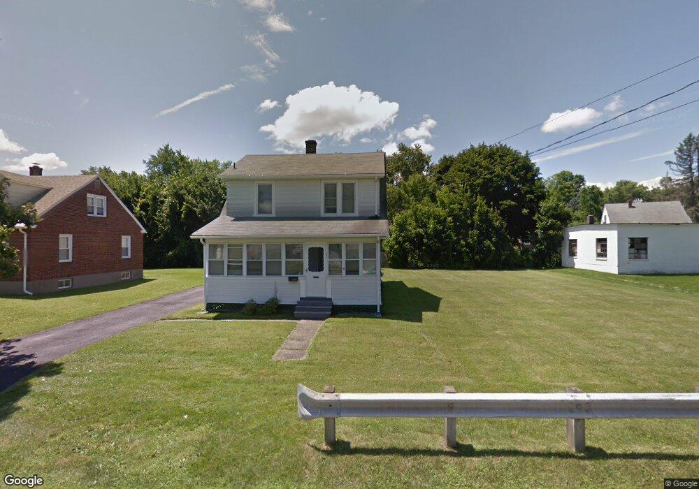
211 Benedict Rd Pittsfield, MA 01201
Estimated Value: $273,000 - $295,000
3
Beds
2
Baths
1,320
Sq Ft
$216/Sq Ft
Est. Value
About This Home
This home is located at 211 Benedict Rd, Pittsfield, MA 01201 and is currently estimated at $285,397, approximately $216 per square foot. 211 Benedict Rd is a home located in Berkshire County with nearby schools including Allendale Elementary School, Theodore Herberg Middle School, and Sinai Academy of the Berkshires.
Ownership History
Date
Name
Owned For
Owner Type
Purchase Details
Closed on
Jun 2, 2023
Sold by
Mccoy Dwayne G
Bought by
Mccoy Marsha A and Mccoy Dwayne G
Current Estimated Value
Purchase Details
Closed on
Jul 19, 1991
Sold by
Santy Donald F
Bought by
Santy Eveline
Create a Home Valuation Report for This Property
The Home Valuation Report is an in-depth analysis detailing your home's value as well as a comparison with similar homes in the area
Home Values in the Area
Average Home Value in this Area
Purchase History
| Date | Buyer | Sale Price | Title Company |
|---|---|---|---|
| Mccoy Marsha A | -- | None Available | |
| Mccoy Marsha A | -- | None Available | |
| Mccoy Marsha A | -- | None Available | |
| Santy Eveline | $45,000 | -- | |
| Santy Eveline | $45,000 | -- |
Source: Public Records
Tax History Compared to Growth
Tax History
| Year | Tax Paid | Tax Assessment Tax Assessment Total Assessment is a certain percentage of the fair market value that is determined by local assessors to be the total taxable value of land and additions on the property. | Land | Improvement |
|---|---|---|---|---|
| 2025 | $4,431 | $247,000 | $70,000 | $177,000 |
| 2024 | $4,120 | $223,300 | $70,000 | $153,300 |
| 2023 | $3,836 | $209,400 | $70,000 | $139,400 |
| 2022 | $3,460 | $186,400 | $65,000 | $121,400 |
| 2021 | $2,999 | $155,800 | $65,000 | $90,800 |
| 2020 | $2,753 | $139,700 | $52,000 | $87,700 |
| 2019 | $2,573 | $132,500 | $48,000 | $84,500 |
| 2018 | $2,589 | $129,400 | $48,000 | $81,400 |
| 2017 | $2,520 | $128,400 | $50,000 | $78,400 |
| 2016 | $2,150 | $114,600 | $38,000 | $76,600 |
| 2015 | $2,070 | $114,600 | $38,000 | $76,600 |
Source: Public Records
Map
Nearby Homes
- 36 Pittsfield Ave
- 81 Dartmouth St Unit 102
- 156 Draper Ave
- 919 Tyler St
- 153 Elberon Ave
- I11001904 Scammell Ave
- 67 Scammell Ave
- 135 Allengate Ave
- 326 Dalton Ave
- LOT 20 Plunkett St
- 122 Allengate Ave
- 52 Bossidy Dr
- 0 Brown St
- 48 Brown St
- 24 Glenwood Ave
- 41 Brown St
- 29 Glenwood Ave
- 87 Maryland Ave
- 56 Spring St
- 0 Courtland Place
- 203 Benedict Rd
- 42 Ensign Ave
- 32 Ensign Ave
- 170 E Park Terrace
- 225 Benedict Rd
- 206 Benedict Rd
- 214 Benedict Rd
- 26 Ensign Ave
- 200 Benedict Rd
- 218 Benedict Rd
- 167 E Park Terrace
- 44 Stanley Ave
- 0 Ensign Ave
- 196 Benedict Rd
- 189 Benedict Rd
- 224 Benedict Rd
- 163 E Park Terrace
- 18 Ensign Ave
- 27 Ensign Ave
- 192 Benedict Rd