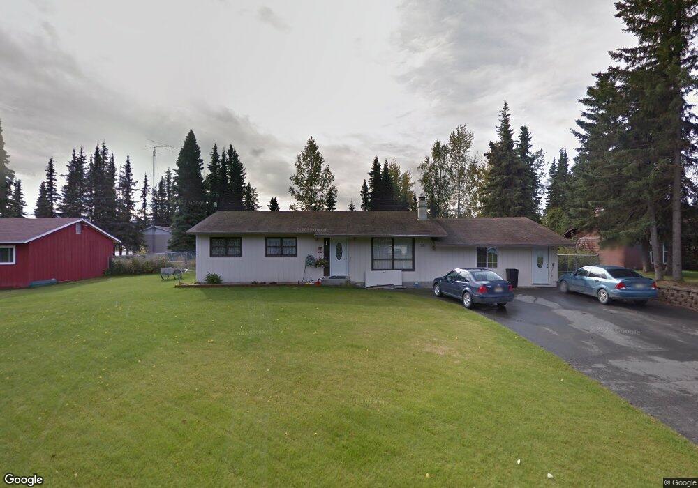
211 Crest Dr Soldotna, AK 99669
Estimated Value: $148,000 - $367,000
3
Beds
3
Baths
1,912
Sq Ft
$149/Sq Ft
Est. Value
About This Home
This home is located at 211 Crest Dr, Soldotna, AK 99669 and is currently estimated at $284,353, approximately $148 per square foot. 211 Crest Dr is a home located in Kenai Peninsula Borough with nearby schools including Redoubt Elementary School, Skyview Middle School, and Soldotna High School.
Ownership History
Date
Name
Owned For
Owner Type
Purchase Details
Closed on
Aug 14, 2018
Sold by
Haag Kenneth E
Bought by
Coombes David
Current Estimated Value
Purchase Details
Closed on
Feb 25, 2008
Sold by
Coombes Laurel A
Bought by
Coombes David E
Home Financials for this Owner
Home Financials are based on the most recent Mortgage that was taken out on this home.
Original Mortgage
$95,000
Interest Rate
5.64%
Mortgage Type
Purchase Money Mortgage
Create a Home Valuation Report for This Property
The Home Valuation Report is an in-depth analysis detailing your home's value as well as a comparison with similar homes in the area
Home Values in the Area
Average Home Value in this Area
Purchase History
| Date | Buyer | Sale Price | Title Company |
|---|---|---|---|
| Coombes David | -- | None Available | |
| Coombes David E | -- | Stewart Title Of The Kenai P |
Source: Public Records
Mortgage History
| Date | Status | Borrower | Loan Amount |
|---|---|---|---|
| Previous Owner | Coombes David E | $95,000 |
Source: Public Records
Tax History Compared to Growth
Tax History
| Year | Tax Paid | Tax Assessment Tax Assessment Total Assessment is a certain percentage of the fair market value that is determined by local assessors to be the total taxable value of land and additions on the property. | Land | Improvement |
|---|---|---|---|---|
| 2025 | $1,747 | $285,600 | $42,600 | $243,000 |
| 2024 | $873 | $264,700 | $41,600 | $223,100 |
| 2023 | $1,556 | $240,900 | $37,800 | $203,100 |
| 2022 | $1,488 | $236,100 | $36,000 | $200,100 |
| 2021 | $1,286 | $219,600 | $26,700 | $192,900 |
| 2020 | $1,265 | $203,800 | $26,700 | $177,100 |
| 2019 | $1,248 | $201,700 | $24,300 | $177,400 |
| 2018 | $1,286 | $206,400 | $24,300 | $182,100 |
| 2017 | $1,141 | $196,600 | $24,300 | $172,300 |
| 2016 | $1,093 | $188,200 | $24,300 | $163,900 |
| 2015 | $1,109 | $181,100 | $24,300 | $156,800 |
| 2014 | $1,109 | $178,800 | $24,300 | $154,500 |
Source: Public Records
Map
Nearby Homes
- 327 Knight Dr
- 265 Charity Cir
- 35839 Irons Ave
- 35841 Irons Ave
- L42 N Aspen Dr
- 235 N Aspen Dr
- 35870 Glory St
- 35868 Everwell Place
- 35856 Everwell Place
- 35840 Everwell Place
- 386 W Corral Ave
- 169 N Brentwood St
- 36050 Irons Ave
- 000 Ridgewood Dr
- L1 Kenai Spur Hwy
- 256 Upper Rosian Dr
- 253 Upper Rosian Dr
- 366 Diane Ln
- 150 S Leibrock St
- 190 Trumpeter Ave
- 219 Crest Dr
- 203 Crest Dr
- 212 W Marydale Ave
- 229 Crest Dr
- 220 W Marydale Ave
- 212 Crest Dr
- 228 W Marydale Ave
- 228 W Marydale Ave Unit U
- 228 W Marydale Ave Unit 2
- L10 B1 Edwards Ct
- 329 Edwards Ct
- 321 Edwards Ct
- 317 Edwards Ct
- 337 Edwards Ct
- 337 N Fireweed St
- 235 Crest Dr
- 322 N Fireweed St
- 314 N Fireweed St
- 330 N Fireweed St
- 236 W Marydale Ave