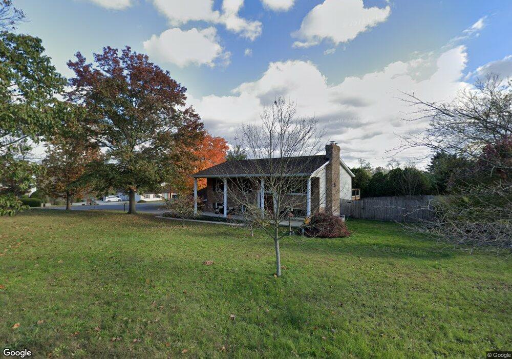
211 Curtis Dr Carlisle, PA 17013
Estimated Value: $347,000 - $447,000
4
Beds
3
Baths
2,240
Sq Ft
$177/Sq Ft
Est. Value
About This Home
This home is located at 211 Curtis Dr, Carlisle, PA 17013 and is currently estimated at $397,022, approximately $177 per square foot. 211 Curtis Dr is a home located in Cumberland County with nearby schools including Bellaire Elementary School, Wilson Middle School, and Carlisle Area High School.
Ownership History
Date
Name
Owned For
Owner Type
Purchase Details
Closed on
Apr 18, 2005
Sold by
Davis Rick
Bought by
Grabosky Zachary W
Current Estimated Value
Home Financials for this Owner
Home Financials are based on the most recent Mortgage that was taken out on this home.
Original Mortgage
$100,000
Outstanding Balance
$51,905
Interest Rate
5.87%
Mortgage Type
New Conventional
Estimated Equity
$345,117
Create a Home Valuation Report for This Property
The Home Valuation Report is an in-depth analysis detailing your home's value as well as a comparison with similar homes in the area
Home Values in the Area
Average Home Value in this Area
Purchase History
| Date | Buyer | Sale Price | Title Company |
|---|---|---|---|
| Grabosky Zachary W | $169,900 | -- |
Source: Public Records
Mortgage History
| Date | Status | Borrower | Loan Amount |
|---|---|---|---|
| Open | Grabosky Zachary W | $100,000 |
Source: Public Records
Tax History Compared to Growth
Tax History
| Year | Tax Paid | Tax Assessment Tax Assessment Total Assessment is a certain percentage of the fair market value that is determined by local assessors to be the total taxable value of land and additions on the property. | Land | Improvement |
|---|---|---|---|---|
| 2025 | $4,018 | $191,800 | $60,000 | $131,800 |
| 2024 | $3,866 | $191,800 | $60,000 | $131,800 |
| 2023 | $3,726 | $191,800 | $60,000 | $131,800 |
| 2022 | $3,666 | $191,800 | $60,000 | $131,800 |
| 2021 | $3,607 | $191,800 | $60,000 | $131,800 |
| 2020 | $3,521 | $191,800 | $60,000 | $131,800 |
| 2019 | $3,438 | $191,800 | $60,000 | $131,800 |
| 2018 | $3,348 | $191,800 | $60,000 | $131,800 |
| 2017 | $3,272 | $191,800 | $60,000 | $131,800 |
| 2016 | -- | $191,800 | $60,000 | $131,800 |
| 2015 | -- | $191,800 | $60,000 | $131,800 |
| 2014 | -- | $191,800 | $60,000 | $131,800 |
Source: Public Records
Map
Nearby Homes
- 181 Shatto Dr
- 140 Shatto Dr
- 40 Moongale Dr
- 10 Family Dr
- 2 Stream Dr
- 10 Stream Dr
- 4 Stream Dr
- 23 American Ave
- 21 American Ave
- 3 Lantern Ct
- 6 Stream Dr
- 12 Family Dr
- Bryson Plan at Hays Landing
- Monroe Plan at Hays Landing
- Willow Plan at Hays Landing
- Mackenzie Plan at Hays Landing
- Cooper Plan at Hays Landing
- Charlotte Plan at Hays Landing
- Dalton Plan at Hays Landing
- Heron Plan at Hays Landing
- 210 Shatto Dr
- 201 Lamplite Dr
- 201 Shatto Dr
- 220 Shatto Dr
- 211 Lamplite Dr
- 191 Shatto Dr
- 190 Shatto Dr
- 230 Shatto Dr
- 221 Lamplite Dr
- 191 Candlelite Dr
- 210 Lamplite Dr
- 170 Shatto Dr
- 161 Candlelite Dr
- 201 Candlelite Dr
- 220 Lamplite Dr
- 171 Shatto Dr
- 231 Lamplite Dr
- 160 Shatto Dr
- 241 Shatto Dr
- 10 Curtis Dr