Estimated Value: $159,000 - $176,000
3
Beds
2
Baths
1,226
Sq Ft
$138/Sq Ft
Est. Value
About This Home
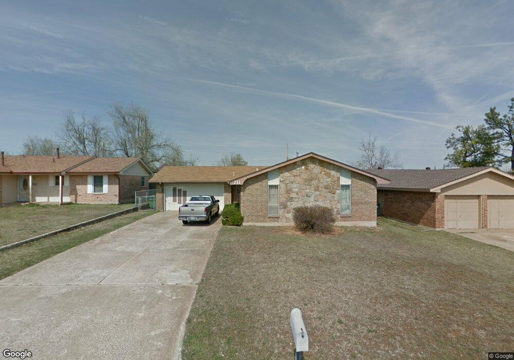
This home is located at 211 E Beam Dr, Yukon, OK 73099 and is currently estimated at $169,490, approximately $138 per square foot. 211 E Beam Dr is a home located in Canadian County with nearby schools including Myers Elementary School, Independence Elementary School, and Yukon Middle School.
Ownership History
Date
Name
Owned For
Owner Type
Purchase Details
Closed on
Nov 8, 2002
Sold by
Hanks Leo C and Linda K~Trustees
Bought by
Hanks Leo C and Hanks Linda K
Current Estimated Value
Home Financials for this Owner
Home Financials are based on the most recent Mortgage that was taken out on this home.
Original Mortgage
$44,800
Outstanding Balance
$18,060
Interest Rate
5.89%
Estimated Equity
$151,430
Purchase Details
Closed on
Aug 3, 1999
Sold by
Hanks Leo and Hanks L
Purchase Details
Closed on
Dec 30, 1996
Sold by
Hathaway,Roseary Jean Trust
Create a Home Valuation Report for This Property
The Home Valuation Report is an in-depth analysis detailing your home's value as well as a comparison with similar homes in the area
Home Values in the Area
Average Home Value in this Area
Purchase History
| Date | Buyer | Sale Price | Title Company |
|---|---|---|---|
| Hanks Leo C | $70,000 | -- | |
| -- | -- | -- | |
| -- | -- | -- |
Source: Public Records
Mortgage History
| Date | Status | Borrower | Loan Amount |
|---|---|---|---|
| Open | Hanks Leo C | $44,800 |
Source: Public Records
Tax History
| Year | Tax Paid | Tax Assessment Tax Assessment Total Assessment is a certain percentage of the fair market value that is determined by local assessors to be the total taxable value of land and additions on the property. | Land | Improvement |
|---|---|---|---|---|
| 2025 | $698 | $7,479 | $782 | $6,697 |
| 2024 | $702 | $7,479 | $696 | $6,783 |
| 2023 | $702 | $7,479 | $744 | $6,735 |
| 2022 | $705 | $7,478 | $942 | $6,536 |
| 2021 | $707 | $7,479 | $1,140 | $6,339 |
| 2020 | $699 | $7,479 | $1,115 | $6,364 |
| 2019 | $701 | $7,479 | $1,115 | $6,364 |
| 2018 | $703 | $7,479 | $1,183 | $6,296 |
| 2017 | $703 | $7,478 | $1,221 | $6,257 |
| 2016 | $704 | $7,479 | $1,327 | $6,152 |
| 2015 | $714 | $7,479 | $1,391 | $6,088 |
| 2014 | $714 | $7,479 | $1,391 | $6,088 |
Source: Public Records
Map
Nearby Homes
- 0 Landon Ln
- 218 Klondike Dr
- 207 Klondike Dr
- 103 Aspen Dr
- 1203 Ridgeway Dr
- 109 W Vandament Ave
- 9 Vine St
- 13228 SW 8th St
- 325 Choctaw Place
- 308 Choctaw Place
- 321 Cherokee Dr
- 212 Cherokee Dr
- 3225 Pagoda Pead Dr
- 203 Redbud St
- 14500 Giverny Ln
- 14524 Giverny Ln
- 116 Seminole Ln
- 317 Asbill Ave
- 723 Garden Grove
- 1710 Ronald St
- 209 E Beam Dr
- 213 E Beam Dr
- 212 Klondike Dr
- 207 E Beam Dr
- 215 E Beam Dr
- 210 Klondike Dr
- 214 Klondike Dr
- 208 Klondike Dr
- 210 E Beam Dr
- 216 Klondike Dr
- 205 E Beam Dr
- 212 E Beam Dr
- 208 E Beam Dr
- 214 E Beam Dr
- 206 E Beam Dr
- 206 Klondike Dr
- 204 E Beam Dr
- 216 E Beam Dr
- 1004 E Willow Place
- 1002 E Willow Place
Your Personal Tour Guide
Ask me questions while you tour the home.