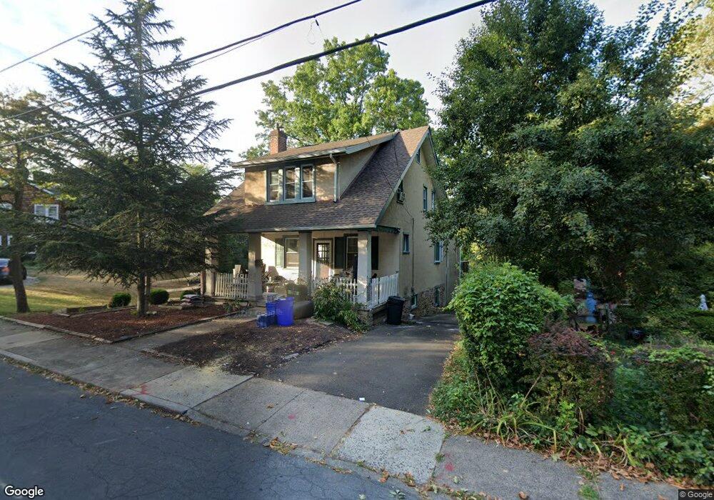
211 E Mill Rd Hatboro, PA 19040
Estimated Value: $418,901 - $479,000
3
Beds
2
Baths
1,656
Sq Ft
$272/Sq Ft
Est. Value
About This Home
This home is located at 211 E Mill Rd, Hatboro, PA 19040 and is currently estimated at $450,225, approximately $271 per square foot. 211 E Mill Rd is a home located in Montgomery County with nearby schools including Keith Valley Middle School, Hatboro-Horsham Senior High School, and Queen of Angels Regional Catholic School.
Ownership History
Date
Name
Owned For
Owner Type
Purchase Details
Closed on
Dec 30, 2004
Sold by
Glatthorn Teresa Ann
Bought by
Karow Stephen O and Karow Meredith Mchugh
Current Estimated Value
Home Financials for this Owner
Home Financials are based on the most recent Mortgage that was taken out on this home.
Original Mortgage
$261,250
Outstanding Balance
$157,157
Interest Rate
9.25%
Mortgage Type
Adjustable Rate Mortgage/ARM
Estimated Equity
$293,068
Purchase Details
Closed on
Mar 24, 1998
Sold by
Glatthorn Dale A and Glatthorn Teresa Ann
Bought by
Glatthorn Teresa Ann
Create a Home Valuation Report for This Property
The Home Valuation Report is an in-depth analysis detailing your home's value as well as a comparison with similar homes in the area
Home Values in the Area
Average Home Value in this Area
Purchase History
| Date | Buyer | Sale Price | Title Company |
|---|---|---|---|
| Karow Stephen O | $275,000 | None Available | |
| Glatthorn Teresa Ann | -- | -- |
Source: Public Records
Mortgage History
| Date | Status | Borrower | Loan Amount |
|---|---|---|---|
| Open | Karow Stephen O | $261,250 |
Source: Public Records
Tax History
| Year | Tax Paid | Tax Assessment Tax Assessment Total Assessment is a certain percentage of the fair market value that is determined by local assessors to be the total taxable value of land and additions on the property. | Land | Improvement |
|---|---|---|---|---|
| 2025 | $5,677 | $117,150 | $40,430 | $76,720 |
| 2024 | $5,677 | $117,150 | $40,430 | $76,720 |
| 2023 | $5,403 | $117,150 | $40,430 | $76,720 |
| 2022 | $5,261 | $117,150 | $40,430 | $76,720 |
| 2021 | $5,135 | $117,150 | $40,430 | $76,720 |
| 2020 | $4,985 | $117,150 | $40,430 | $76,720 |
| 2019 | $4,907 | $117,150 | $40,430 | $76,720 |
Source: Public Records
Map
Nearby Homes
- 142 Greenbelt Dr
- 501 Windover Rd
- 237 Byberry Rd
- 213 Green Lane Terrace
- 2411 Horsham Rd
- 201 Castello Ave
- 165 W Moreland Ave
- 229 Warren St
- 2703 Parkside Ave
- 604 Fairhill St
- 2625 Horsham Rd
- 330 Windsor Ave
- 509 Exton Rd
- 435 Newton Rd
- 42 Russell Rd
- 515 N York Rd Unit 1C
- 416 Preston Ln
- 513 Stewart Rd
- 465 Jacksonville Rd
- 401 Red Barn Rd
Your Personal Tour Guide
Ask me questions while you tour the home.