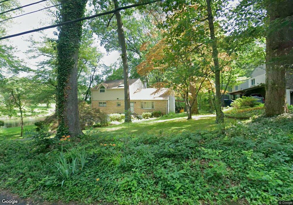
211 East Rd Doylestown, PA 18901
Estimated Value: $600,268 - $713,000
3
Beds
2
Baths
2,016
Sq Ft
$317/Sq Ft
Est. Value
About This Home
This home is located at 211 East Rd, Doylestown, PA 18901 and is currently estimated at $638,817, approximately $316 per square foot. 211 East Rd is a home located in Bucks County with nearby schools including Kutz Elementary School, Lenape Middle School, and Central Bucks High School-West.
Ownership History
Date
Name
Owned For
Owner Type
Purchase Details
Closed on
Jun 4, 2009
Sold by
Glenn Floyd A and Schiff Cynthia M
Bought by
Meisinger Paul D
Current Estimated Value
Home Financials for this Owner
Home Financials are based on the most recent Mortgage that was taken out on this home.
Original Mortgage
$289,600
Outstanding Balance
$183,565
Interest Rate
4.83%
Mortgage Type
Purchase Money Mortgage
Estimated Equity
$455,252
Purchase Details
Closed on
Oct 25, 1978
Bought by
Glenn Floyd A and Glenn Chiff,Cynthia
Create a Home Valuation Report for This Property
The Home Valuation Report is an in-depth analysis detailing your home's value as well as a comparison with similar homes in the area
Home Values in the Area
Average Home Value in this Area
Purchase History
| Date | Buyer | Sale Price | Title Company |
|---|---|---|---|
| Meisinger Paul D | $362,000 | None Available | |
| Glenn Floyd A | $57,000 | -- |
Source: Public Records
Mortgage History
| Date | Status | Borrower | Loan Amount |
|---|---|---|---|
| Open | Meisinger Paul D | $289,600 |
Source: Public Records
Tax History
| Year | Tax Paid | Tax Assessment Tax Assessment Total Assessment is a certain percentage of the fair market value that is determined by local assessors to be the total taxable value of land and additions on the property. | Land | Improvement |
|---|---|---|---|---|
| 2025 | $5,266 | $29,760 | $5,920 | $23,840 |
| 2024 | $5,266 | $29,760 | $5,920 | $23,840 |
| 2023 | $5,022 | $29,760 | $5,920 | $23,840 |
| 2022 | $4,966 | $29,760 | $5,920 | $23,840 |
| 2021 | $4,864 | $29,760 | $5,920 | $23,840 |
| 2020 | $4,841 | $29,760 | $5,920 | $23,840 |
| 2019 | $4,789 | $29,760 | $5,920 | $23,840 |
| 2018 | $4,774 | $29,760 | $5,920 | $23,840 |
| 2017 | $4,737 | $29,760 | $5,920 | $23,840 |
| 2016 | $4,707 | $29,760 | $5,920 | $23,840 |
| 2015 | -- | $29,760 | $5,920 | $23,840 |
| 2014 | -- | $29,760 | $5,920 | $23,840 |
Source: Public Records
Map
Nearby Homes
- 34 Houk Rd
- 45 Springs Dr
- 000 Cherry Ln
- 117 Windover Ln
- 150 Watercrest Dr
- 223 Cherry Ln
- 152 Watercrest Dr
- 563 Pebble Hill Rd
- 3795 Route 202
- 3775 Buckingham Dr
- 2980 Yorkshire Rd
- 2361 Turk Rd
- 5 Belmont Square
- 607 S Chubb Dr
- 236 Green St
- 110 E Ashland St
- 69 E Oakland Ave
- 146 E Court St
- 3889 Robin Rd
- 106 Saddle Dr
Your Personal Tour Guide
Ask me questions while you tour the home.