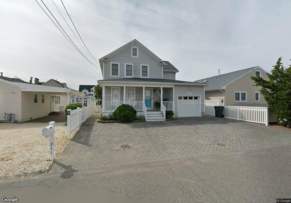
211 Hayes Ct Lavallette, NJ 08735
Dover Beaches North NeighborhoodEstimated Value: $1,358,000 - $1,868,000
5
Beds
3
Baths
2,596
Sq Ft
$615/Sq Ft
Est. Value
About This Home
This home is located at 211 Hayes Ct, Lavallette, NJ 08735 and is currently estimated at $1,595,729, approximately $614 per square foot. 211 Hayes Ct is a home located in Ocean County.
Ownership History
Date
Name
Owned For
Owner Type
Purchase Details
Closed on
Oct 9, 2020
Sold by
Finne Darlene
Bought by
Westdyk Thomas and Westdyk Catherine
Current Estimated Value
Home Financials for this Owner
Home Financials are based on the most recent Mortgage that was taken out on this home.
Original Mortgage
$746,250
Outstanding Balance
$661,880
Interest Rate
2.87%
Mortgage Type
New Conventional
Estimated Equity
$933,849
Purchase Details
Closed on
Oct 26, 2004
Sold by
Finne Robert M
Bought by
Finne Darlene
Purchase Details
Closed on
May 27, 1999
Sold by
Vandoren Arthur D and Vandoren Mary Genevieve
Bought by
Finne Robert M and Finne Darlene L
Home Financials for this Owner
Home Financials are based on the most recent Mortgage that was taken out on this home.
Original Mortgage
$240,000
Interest Rate
6.9%
Mortgage Type
Stand Alone First
Purchase Details
Closed on
Oct 15, 1997
Sold by
Pfaff Martha B
Bought by
Vandoren Arthur and Genevieve Vandoren M
Create a Home Valuation Report for This Property
The Home Valuation Report is an in-depth analysis detailing your home's value as well as a comparison with similar homes in the area
Home Values in the Area
Average Home Value in this Area
Purchase History
| Date | Buyer | Sale Price | Title Company |
|---|---|---|---|
| Westdyk Thomas | $995,000 | Evident Title Agency | |
| Finne Darlene | -- | -- | |
| Finne Robert M | $410,000 | -- | |
| Vandoren Arthur | $145,000 | -- |
Source: Public Records
Mortgage History
| Date | Status | Borrower | Loan Amount |
|---|---|---|---|
| Open | Westdyk Thomas | $746,250 | |
| Previous Owner | Finne Robert M | $240,000 |
Source: Public Records
Tax History
| Year | Tax Paid | Tax Assessment Tax Assessment Total Assessment is a certain percentage of the fair market value that is determined by local assessors to be the total taxable value of land and additions on the property. | Land | Improvement |
|---|---|---|---|---|
| 2025 | $19,452 | $995,500 | $630,000 | $365,500 |
| 2024 | $17,232 | $995,500 | $630,000 | $365,500 |
| 2023 | $16,615 | $995,500 | $630,000 | $365,500 |
| 2022 | $16,615 | $995,500 | $630,000 | $365,500 |
| 2021 | $15,250 | $608,800 | $378,200 | $230,600 |
| 2020 | $15,183 | $608,800 | $378,200 | $230,600 |
| 2019 | $14,526 | $608,800 | $378,200 | $230,600 |
| 2018 | $14,331 | $608,800 | $378,200 | $230,600 |
| 2017 | $14,209 | $608,800 | $378,200 | $230,600 |
| 2016 | $13,838 | $608,800 | $378,200 | $230,600 |
| 2015 | $13,314 | $608,800 | $378,200 | $230,600 |
| 2014 | $12,675 | $608,800 | $378,200 | $230,600 |
Source: Public Records
Map
Nearby Homes
- 100 3rd Ave
- 417 Delray Dr
- 201 5th Ave
- 254 Harbor Ct
- 545 New Jersey 35
- 170 W Beach Way
- 155 W Atlantic Way
- 348 Venice Dr
- 109 W Tarpon Way
- 459 Boca Raton Dr
- 515 New Jersey 35
- 53 E Bay Way
- 111 W Marlin Way
- 499 Ellison Dr
- 354 Naples Ct
- 359 Naples Ct
- 112 Neptune Ct
- 20 E Bonita Way
- 33 E Penguin Way
- 351 W Bayview Dr
Your Personal Tour Guide
Ask me questions while you tour the home.