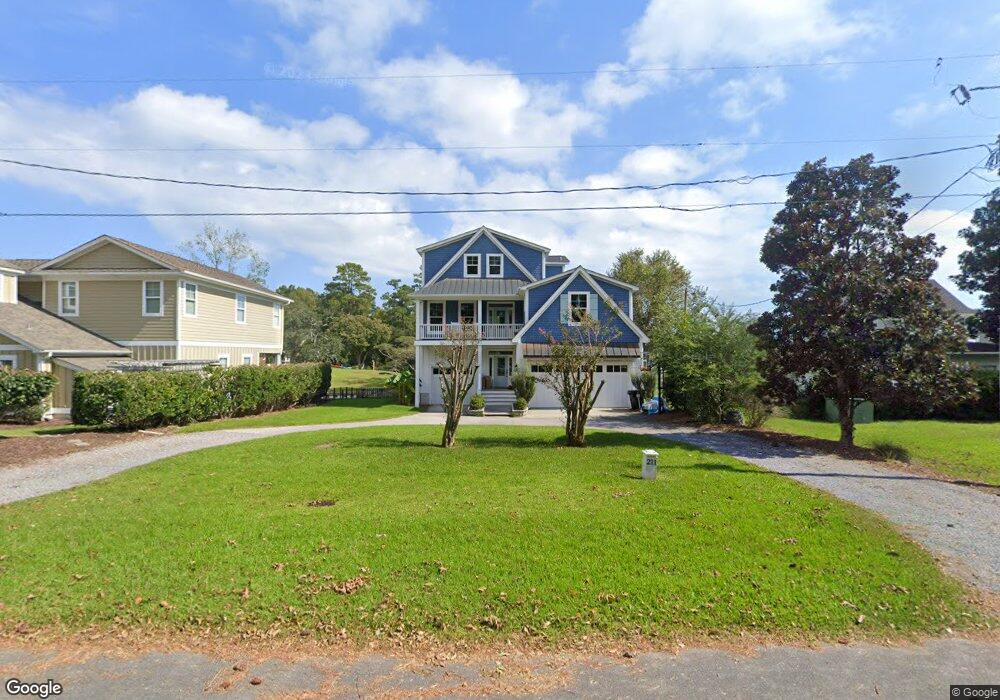
211 Hl Smith Rd Wilmington, NC 28411
Estimated Value: $721,000 - $844,587
--
Bed
4
Baths
2,268
Sq Ft
$347/Sq Ft
Est. Value
About This Home
This home is located at 211 Hl Smith Rd, Wilmington, NC 28411 and is currently estimated at $786,897, approximately $346 per square foot. 211 Hl Smith Rd is a home located in Pender County with nearby schools including South Topsail Elementary School, Topsail Middle School, and Topsail High School.
Ownership History
Date
Name
Owned For
Owner Type
Purchase Details
Closed on
Jan 27, 2014
Sold by
Ivey Anthony Wayne and Ivey Carol Knapp
Bought by
Bullock David M and Bullock Alyssa S
Current Estimated Value
Home Financials for this Owner
Home Financials are based on the most recent Mortgage that was taken out on this home.
Original Mortgage
$400,000
Outstanding Balance
$282,906
Interest Rate
2.75%
Mortgage Type
Adjustable Rate Mortgage/ARM
Estimated Equity
$503,991
Create a Home Valuation Report for This Property
The Home Valuation Report is an in-depth analysis detailing your home's value as well as a comparison with similar homes in the area
Home Values in the Area
Average Home Value in this Area
Purchase History
| Date | Buyer | Sale Price | Title Company |
|---|---|---|---|
| Bullock David M | $500,000 | None Available |
Source: Public Records
Mortgage History
| Date | Status | Borrower | Loan Amount |
|---|---|---|---|
| Open | Bullock David M | $400,000 |
Source: Public Records
Tax History Compared to Growth
Tax History
| Year | Tax Paid | Tax Assessment Tax Assessment Total Assessment is a certain percentage of the fair market value that is determined by local assessors to be the total taxable value of land and additions on the property. | Land | Improvement |
|---|---|---|---|---|
| 2024 | $4,988 | $517,593 | $233,067 | $284,526 |
| 2023 | $4,988 | $517,593 | $233,067 | $284,526 |
| 2022 | $4,419 | $517,593 | $233,067 | $284,526 |
| 2021 | $4,419 | $517,593 | $233,067 | $284,526 |
| 2020 | $5,571 | $655,970 | $233,067 | $422,903 |
| 2019 | $2,805 | $323,753 | $233,067 | $90,686 |
| 2018 | $5,027 | $563,498 | $292,125 | $271,373 |
| 2017 | $5,027 | $563,498 | $292,125 | $271,373 |
| 2016 | $4,970 | $563,498 | $292,125 | $271,373 |
| 2015 | $4,952 | $563,498 | $292,125 | $271,373 |
| 2014 | $3,859 | $563,498 | $292,125 | $271,373 |
| 2013 | -- | $563,498 | $292,125 | $271,373 |
| 2012 | -- | $563,498 | $292,125 | $271,373 |
Source: Public Records
Map
Nearby Homes
- 115 Scottsdale Dr
- 126 Francis Marion Dr
- 112 Francis Marion Dr
- 8948 Woodcreek Cir
- 8956 Woodcreek Cir
- 8707 Lowes Island Dr
- 109 Live Oak Ln
- 1117 Futch Creek Rd
- 8509 Galloway National Dr
- 2165 Scotts Hill Loop Rd
- 348 Lafayette St
- 2100 Scotts Hill Loop Rd
- 1012 Creekside Ln
- 8702 Thornblade Cir
- Tract 200a Padrick Ln
- 8603 Hammock Dunes Dr
- 8709 Decoy Ln
- 202 Cedar Find Cove
- 216 La Salle St
- 8509 Bald Eagle Ln
- 211 H L Smith Rd
- 221 Hl Smith Rd
- 191 H L Smith Rd
- 191 Hl Smith Rd
- 181 Hl Smith Rd
- 181 H L Smith Rd
- 241 Hl Smith Rd
- 241 H L Smith Rd
- 191 Hl Smith
- 161 H L Smith Rd
- 161 Hl Smith Rd
- 47 E Foys Creek Ln
- 282 H L Smith Rd
- 32 E Foys Creek Ln
- 22 E Foys Creek Ln
- 10 E Foys Creek Ln
- 141 Hl Smith Rd
- 113 Hl Smith Rd
- 113 H L Smith Rd
- 252 Osprey Place