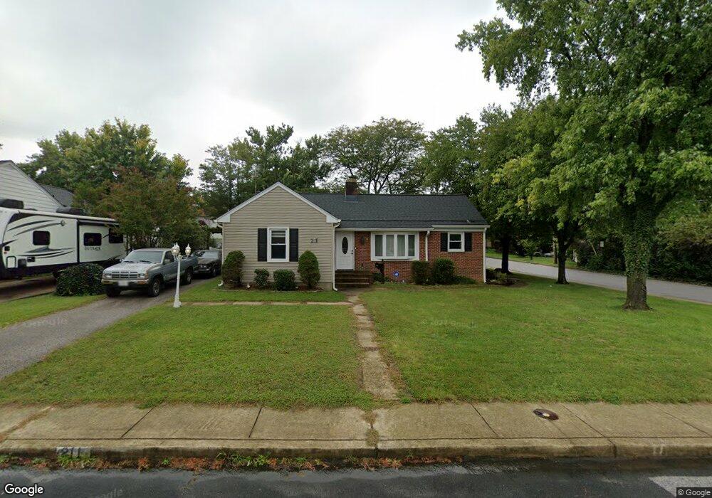
211 Mountain Rd Linthicum Heights, MD 21090
Estimated Value: $351,462 - $455,000
Studio
1
Bath
1,635
Sq Ft
$251/Sq Ft
Est. Value
About This Home
This home is located at 211 Mountain Rd, Linthicum Heights, MD 21090 and is currently estimated at $409,866, approximately $250 per square foot. 211 Mountain Rd is a home located in Anne Arundel County with nearby schools including Overlook Elementary School, Lindale Middle School, and North County High School.
Ownership History
Date
Name
Owned For
Owner Type
Purchase Details
Closed on
Jun 17, 2009
Sold by
Scott Donald M
Bought by
Scott Co Donald
Current Estimated Value
Purchase Details
Closed on
Aug 13, 2001
Sold by
Secretary Of Veterans Affiars
Bought by
Scott Donald M and Scott Dodris A
Purchase Details
Closed on
Mar 28, 2001
Sold by
Rhodes Mark
Bought by
Secretary Of Veterans Affiars
Purchase Details
Closed on
Jun 27, 1995
Sold by
Cox Carl L
Bought by
Rhodes Mark
Home Financials for this Owner
Home Financials are based on the most recent Mortgage that was taken out on this home.
Original Mortgage
$117,300
Interest Rate
7.82%
Create a Home Valuation Report for This Property
The Home Valuation Report is an in-depth analysis detailing your home's value as well as a comparison with similar homes in the area
Home Values in the Area
Average Home Value in this Area
Purchase History
| Date | Buyer | Sale Price | Title Company |
|---|---|---|---|
| Scott Co Donald | -- | -- | |
| Scott Donald M | $114,500 | -- | |
| Secretary Of Veterans Affiars | $108,400 | -- | |
| Rhodes Mark | $115,000 | -- |
Source: Public Records
Mortgage History
| Date | Status | Borrower | Loan Amount |
|---|---|---|---|
| Previous Owner | Rhodes Mark | $117,300 |
Source: Public Records
Tax History
| Year | Tax Paid | Tax Assessment Tax Assessment Total Assessment is a certain percentage of the fair market value that is determined by local assessors to be the total taxable value of land and additions on the property. | Land | Improvement |
|---|---|---|---|---|
| 2025 | $3,019 | $331,800 | $149,300 | $182,500 |
| 2024 | $3,019 | $316,567 | $0 | $0 |
| 2023 | $2,924 | $301,333 | $0 | $0 |
| 2022 | $2,723 | $286,100 | $134,300 | $151,800 |
| 2020 | $2,587 | $269,233 | $0 | $0 |
| 2019 | $2,542 | $260,800 | $106,600 | $154,200 |
| 2018 | $2,636 | $259,967 | $0 | $0 |
| 2017 | $2,410 | $259,133 | $0 | $0 |
| 2016 | -- | $258,300 | $0 | $0 |
| 2015 | -- | $251,467 | $0 | $0 |
| 2014 | -- | $244,633 | $0 | $0 |
Source: Public Records
Map
Nearby Homes
- 31 Governors Gate Ln
- 100 Governors Gate Ln
- 404 Carl Ave
- 206 Cheddington Rd
- 6028 Belle Grove Rd
- 6838 Baltimore Annapolis Blvd
- P298 & P263 Nursery Rd
- 312 Elizabeth Ave
- 5904 Belle Grove Rd
- 300 Twin Oaks Rd
- 145 Shenandoah Ave
- 312 N Hammonds Ferry Rd
- 105 Michael Ave
- 518 N Rd
- 102 Catalpa Rd
- 5722 Howard Dr
- 5724 Howard Dr
- 5719 Howard Dr
- 5725 Howard Dr
- 2773 Yarnall Rd
- 209 Mountain Rd
- 202 Nancy Ave
- 210 Regency Cir
- 201 Hance Ave
- 208 Regency Cir
- 207 Mountain Rd
- 204 Nancy Ave
- 212 Mountain Rd
- 210 Mountain Rd
- 203 Hance Ave
- 206 Regency Cir
- 208 Mountain Rd
- 206 Nancy Ave
- 205 Mountain Rd
- 200 Hampton Rd
- 205 Hance Ave
- 202 Hance Ave
- 206 Mountain Rd
- 211 Regency Cir
- 204 Regency Cir
Your Personal Tour Guide
Ask me questions while you tour the home.