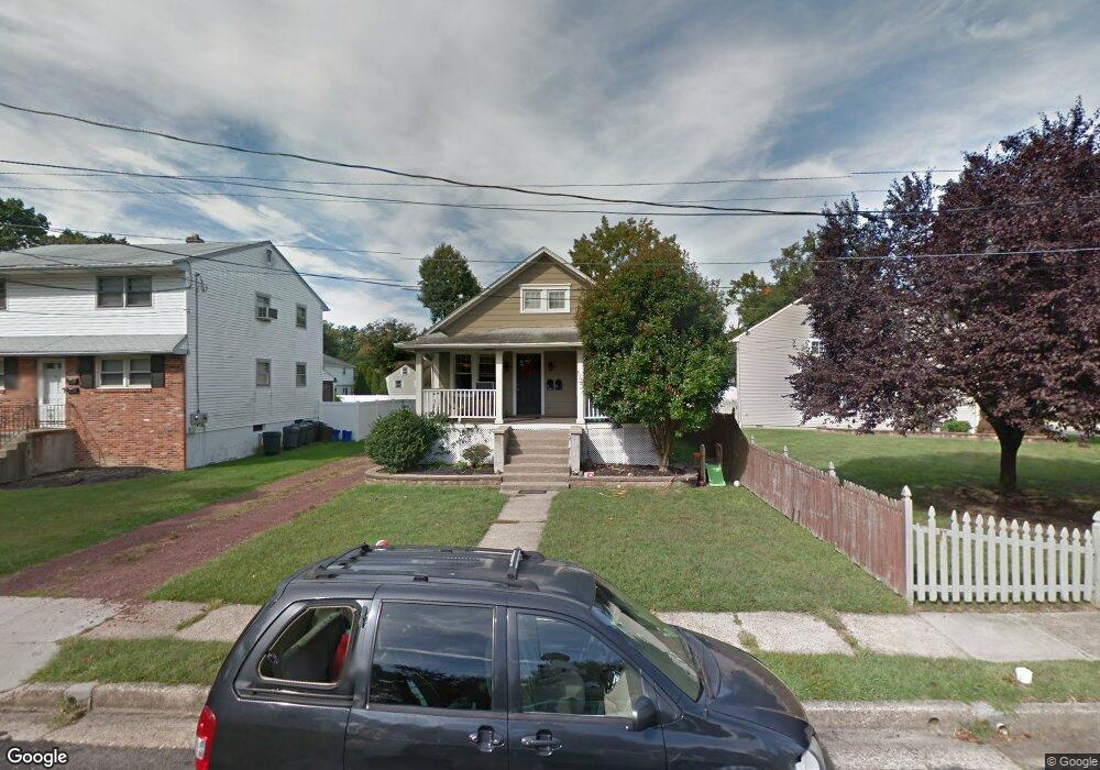
211 Myrtle Ave Mount Ephraim, NJ 08059
Estimated Value: $284,858 - $354,000
Studio
--
Bath
1,734
Sq Ft
$187/Sq Ft
Est. Value
About This Home
This home is located at 211 Myrtle Ave, Mount Ephraim, NJ 08059 and is currently estimated at $324,215, approximately $186 per square foot. 211 Myrtle Ave is a home located in Camden County with nearby schools including Mary Bray Elementary School and Raymond W. Kershaw Elementary School.
Ownership History
Date
Name
Owned For
Owner Type
Purchase Details
Closed on
Dec 6, 2021
Sold by
211 Myrtle Llc
Bought by
Merryfield Daniel M and Merryfield Linda J
Current Estimated Value
Home Financials for this Owner
Home Financials are based on the most recent Mortgage that was taken out on this home.
Original Mortgage
$210,000
Interest Rate
2.43%
Mortgage Type
New Conventional
Purchase Details
Closed on
Feb 19, 2019
Sold by
Merryfield Daniel and Merryfield Linda Jo
Bought by
211 Myrtle Llc
Purchase Details
Closed on
Nov 29, 2004
Sold by
Laura F Roop Est Of
Bought by
Merryfield Daniel and Merryfield Linda Jo
Home Financials for this Owner
Home Financials are based on the most recent Mortgage that was taken out on this home.
Original Mortgage
$103,500
Interest Rate
5.74%
Purchase Details
Closed on
Aug 27, 1994
Sold by
Roop Laura
Bought by
Merryfield Daniel M and Merryfield Linda J
Create a Home Valuation Report for This Property
The Home Valuation Report is an in-depth analysis detailing your home's value as well as a comparison with similar homes in the area
Home Values in the Area
Average Home Value in this Area
Purchase History
| Date | Buyer | Sale Price | Title Company |
|---|---|---|---|
| Merryfield Daniel M | -- | Surety Title | |
| 211 Myrtle Llc | -- | None Available | |
| Merryfield Daniel | $115,000 | -- | |
| Merryfield Daniel M | $25,000 | -- |
Source: Public Records
Mortgage History
| Date | Status | Borrower | Loan Amount |
|---|---|---|---|
| Previous Owner | Merryfield Daniel M | $210,000 | |
| Previous Owner | Merryfield Daniel | $103,500 |
Source: Public Records
Tax History
| Year | Tax Paid | Tax Assessment Tax Assessment Total Assessment is a certain percentage of the fair market value that is determined by local assessors to be the total taxable value of land and additions on the property. | Land | Improvement |
|---|---|---|---|---|
| 2025 | $8,700 | $166,500 | $40,000 | $126,500 |
| 2024 | $8,585 | $166,500 | $40,000 | $126,500 |
Source: Public Records
Map
Nearby Homes
- 117 6th Ave
- 113 Center Ave
- 817 Green Ave
- 27 Lincoln Ave
- 17 W Buckingham Ave
- 40 W Kings Hwy
- 27 Goldy Dr
- 112 Mount Ephraim Ave
- 51 Lincoln Ave
- 12 George St
- 234 Lowell Ave
- 187 Gehrig Ave
- 1417 Chestnut Ave
- 7 Lincoln Ave
- 553 Maple Ave
- 918 Highland Blvd
- 1433 Oriental Ave
- 5 Myrtle Ave
- 1 Myrtle Ave
- 3 Myrtle Ave
- 209 Myrtle Ave
- 601 Station Ave
- 609 Lambert Ave
- 613 Lambert Ave
- 208 Hartka Ave
- 202 Myrtle Ave
- 214 Hartka Ave
- 204 Hartka Ave
- 207 Myrtle Ave Unit B
- 222 Hartka Ave
- 210 6th Ave
- 610 Lambert Ave
- 614 Lambert Ave
- 620 Lambert Ave
- 700 Cedar Ave
- 626 Lambert Ave
- 703 Lambert Ave
- 206 6th Ave
- 305 Pennsylvania Ave
- 301 Pennsylvania Ave
Your Personal Tour Guide
Ask me questions while you tour the home.