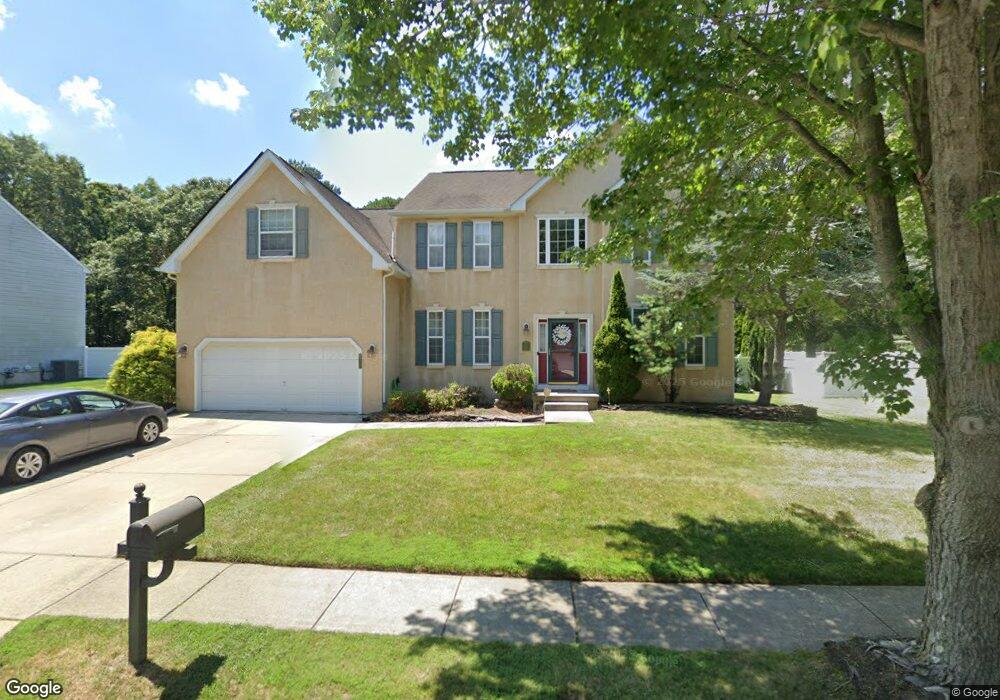
211 Prancer Rd Egg Harbor Township, NJ 08234
Estimated Value: $588,218 - $664,000
Studio
--
Bath
3,368
Sq Ft
$190/Sq Ft
Est. Value
About This Home
This home is located at 211 Prancer Rd, Egg Harbor Township, NJ 08234 and is currently estimated at $639,805, approximately $189 per square foot. 211 Prancer Rd is a home located in Atlantic County with nearby schools including Egg Harbor Township High School, Trinity Learning Center-Holy, and Gospel of Grace Christian School.
Ownership History
Date
Name
Owned For
Owner Type
Purchase Details
Closed on
Dec 12, 2001
Sold by
Group Land Development Ltd
Bought by
Mulino Frank P and Mulino Tammy Lee
Current Estimated Value
Home Financials for this Owner
Home Financials are based on the most recent Mortgage that was taken out on this home.
Original Mortgage
$195,300
Outstanding Balance
$75,577
Interest Rate
7.04%
Estimated Equity
$564,228
Create a Home Valuation Report for This Property
The Home Valuation Report is an in-depth analysis detailing your home's value as well as a comparison with similar homes in the area
Home Values in the Area
Average Home Value in this Area
Purchase History
| Date | Buyer | Sale Price | Title Company |
|---|---|---|---|
| Mulino Frank P | $244,245 | Fidelity National Title Ins |
Source: Public Records
Mortgage History
| Date | Status | Borrower | Loan Amount |
|---|---|---|---|
| Open | Mulino Frank P | $195,300 |
Source: Public Records
Tax History
| Year | Tax Paid | Tax Assessment Tax Assessment Total Assessment is a certain percentage of the fair market value that is determined by local assessors to be the total taxable value of land and additions on the property. | Land | Improvement |
|---|---|---|---|---|
| 2025 | $10,733 | $320,000 | $56,800 | $263,200 |
| 2024 | $10,733 | $320,000 | $56,800 | $263,200 |
Source: Public Records
Map
Nearby Homes
- 422 Delaware Ave
- 416 Delaware Ave
- 117 Offshore Rd
- 7106 Ridge Ave
- 617 Zion Rd
- 218 Surf Rd
- 317 Discovery Ln
- 522 Zion Rd
- 106 Rochelle Ln
- 34 N Mount Airy Ave
- 225 Daytona Rd
- 223 Daytona Rd
- 207 Waterford Rd
- 506 Zion Rd
- 7013 Ridge Ave
- 318 Mcclellan Rd
- 1249 Old Zion Rd
- 517 Superior Rd
- 1055 Old Zion Rd
- 6575 Mill Rd
- 213 Prancer Rd
- 210 Prancer Rd
- 207 Prancer Rd
- 208 Prancer Rd
- 215 Prancer Rd
- 212 Prancer Rd
- 206 Prancer Rd
- 214 Prancer Rd
- 205 Prancer Rd
- 204 Prancer Rd
- 216 Prancer Rd
- 203 Prancer Rd
- 219 Prancer Rd
- 135 Bridle Path Dr
- 137 Bridle Path Dr
- 133 Bridle Path Dr
- 218 Prancer Rd
- 139 Bridle Path Dr
- 131 Bridle Path Dr
- 201 Prancer Rd
Your Personal Tour Guide
Ask me questions while you tour the home.