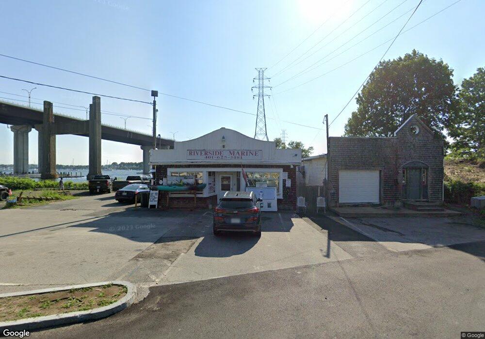
211 Riverside Dr Tiverton, RI 02878
Estimated Value: $978,667
--
Bed
--
Bath
1,182
Sq Ft
$828/Sq Ft
Est. Value
About This Home
This home is located at 211 Riverside Dr, Tiverton, RI 02878 and is currently estimated at $978,667, approximately $827 per square foot. 211 Riverside Dr is a home located in Newport County with nearby schools including Tiverton High School and Saint Stanislaus School.
Ownership History
Date
Name
Owned For
Owner Type
Purchase Details
Closed on
Apr 6, 2017
Sold by
Latinville Alphonse and Latinville Susan
Bought by
Riverside Marina Llc
Current Estimated Value
Home Financials for this Owner
Home Financials are based on the most recent Mortgage that was taken out on this home.
Original Mortgage
$356,250
Outstanding Balance
$296,047
Interest Rate
4.16%
Mortgage Type
Commercial
Estimated Equity
$682,620
Create a Home Valuation Report for This Property
The Home Valuation Report is an in-depth analysis detailing your home's value as well as a comparison with similar homes in the area
Home Values in the Area
Average Home Value in this Area
Purchase History
| Date | Buyer | Sale Price | Title Company |
|---|---|---|---|
| Riverside Marina Llc | $475,000 | -- |
Source: Public Records
Mortgage History
| Date | Status | Borrower | Loan Amount |
|---|---|---|---|
| Open | Riverside Marina Llc | $356,250 |
Source: Public Records
Tax History Compared to Growth
Tax History
| Year | Tax Paid | Tax Assessment Tax Assessment Total Assessment is a certain percentage of the fair market value that is determined by local assessors to be the total taxable value of land and additions on the property. | Land | Improvement |
|---|---|---|---|---|
| 2025 | $5,816 | $526,300 | $259,200 | $267,100 |
| 2024 | $5,816 | $526,300 | $259,200 | $267,100 |
| 2023 | $7,046 | $472,900 | $243,000 | $229,900 |
| 2022 | $6,919 | $472,900 | $243,000 | $229,900 |
| 2021 | $6,748 | $472,900 | $243,000 | $229,900 |
| 2020 | $7,339 | $453,300 | $223,900 | $229,400 |
| 2019 | $7,158 | $453,300 | $223,900 | $229,400 |
| 2018 | $7,430 | $453,300 | $223,900 | $229,400 |
| 2017 | $6,757 | $354,700 | $200,000 | $154,700 |
| 2016 | $6,789 | $354,700 | $200,000 | $154,700 |
| 2015 | $6,577 | $343,600 | $188,900 | $154,700 |
| 2014 | -- | $325,300 | $179,200 | $146,100 |
Source: Public Records
Map
Nearby Homes
- 8 Tucker Ave
- 10 Mount Hope Ave
- 169 Narragansett Blvd
- 51 W Ridge Dr
- 197 Church Pond Dr
- 153 Sakonnet Ridge Dr
- 1660 Main Rd
- 9 Cutter Ln
- 0 Common Fence Blvd Unit 1364650
- 0 Common Fence Blvd Unit 1397142
- 83 Waters Edge Unit 24
- 87 Waters Edge
- 20 Kensington Ave
- 0 Island Rd
- 15 Rocky Ave
- 134 Greenfield Ave
- 174 Highland Rd
- 0 Dighton Ave
- 21 Summit Ave
- 898 Main Rd
- 215 Riverside Dr
- 0 Riverside Dr Unit 1346842
- 0 Riverside Dr Unit 1306019
- 0 Riverside Dr Unit 72957808
- 227 Riverside Dr
- 222 Riverside Dr
- 196 Riverside Dr
- 200 Riverside Dr
- 204 Riverside Dr
- 237 Riverside Dr
- 210 Riverside Dr
- 230 Riverside Dr
- 239 Riverside Dr
- 145 Evans Ave
- 243 Riverside Dr
- 10 Tucker Ave
- 140 Evans Ave
- 123 Evans Ave
- 255 Riverside Dr
- 240 Riverside Dr