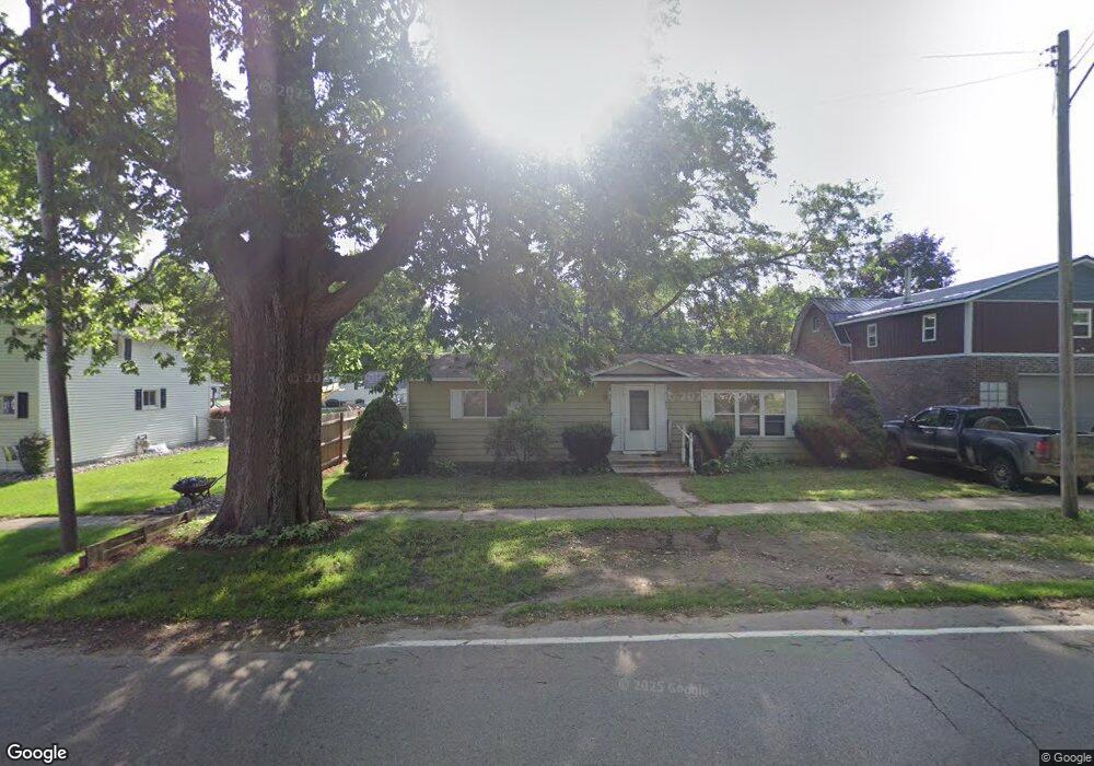
211 S Maple Ave Maple Rapids, MI 48853
Estimated Value: $134,000 - $140,188
2
Beds
1
Bath
1,056
Sq Ft
$130/Sq Ft
Est. Value
About This Home
This home is located at 211 S Maple Ave, Maple Rapids, MI 48853 and is currently estimated at $137,797, approximately $130 per square foot. 211 S Maple Ave is a home located in Clinton County with nearby schools including Fulton Elementary School, Fulton Middle School, and Fulton High School.
Ownership History
Date
Name
Owned For
Owner Type
Purchase Details
Closed on
Nov 5, 2012
Sold by
Patrick Dennis and Patrick Leslie A
Bought by
Material Properties
Current Estimated Value
Purchase Details
Closed on
Apr 20, 2011
Sold by
Ryan Joel K and Ryan Elissa K
Bought by
Firstbank St Johns Mortgage Company
Purchase Details
Closed on
May 16, 2006
Sold by
Salisbury Kimberly
Bought by
Ryan Joel K
Home Financials for this Owner
Home Financials are based on the most recent Mortgage that was taken out on this home.
Original Mortgage
$71,250
Interest Rate
6.54%
Mortgage Type
Fannie Mae Freddie Mac
Create a Home Valuation Report for This Property
The Home Valuation Report is an in-depth analysis detailing your home's value as well as a comparison with similar homes in the area
Purchase History
| Date | Buyer | Sale Price | Title Company |
|---|---|---|---|
| Material Properties | -- | None Available | |
| Firstbank St Johns Mortgage Company | $78,514 | None Available | |
| Ryan Joel K | $75,000 | 1St Title Inc |
Source: Public Records
Mortgage History
| Date | Status | Borrower | Loan Amount |
|---|---|---|---|
| Previous Owner | Ryan Joel K | $71,250 |
Source: Public Records
Tax History
| Year | Tax Paid | Tax Assessment Tax Assessment Total Assessment is a certain percentage of the fair market value that is determined by local assessors to be the total taxable value of land and additions on the property. | Land | Improvement |
|---|---|---|---|---|
| 2025 | $2,047 | $54,000 | $5,600 | $48,400 |
| 2024 | $6 | $48,200 | $5,100 | $43,100 |
| 2023 | $536 | $45,300 | $0 | $0 |
| 2022 | $1,176 | $40,900 | $4,700 | $36,200 |
| 2021 | $1,148 | $36,100 | $4,500 | $31,600 |
| 2020 | $1,056 | $33,400 | $4,300 | $29,100 |
| 2019 | $1,014 | $29,000 | $4,300 | $24,700 |
| 2018 | $990 | $28,000 | $4,300 | $23,700 |
| 2017 | -- | $29,700 | $4,300 | $25,400 |
| 2016 | $961 | $28,200 | $4,300 | $23,900 |
| 2015 | -- | $26,700 | $0 | $0 |
| 2011 | -- | $27,000 | $0 | $0 |
Source: Public Records
Map
Nearby Homes
- 132 E Washington St
- 129 E Main St
- 220 N Maple Ave
- TBD E Main St
- 7240 Empire Rd
- 8095 Mcintosh Rd
- 8150 Idared Rd
- 9515 W Moss Rd
- 00 S Skyline
- 4941 Skyline Dr
- 005 Skyline Dr
- 7150 W Mead Rd
- 159 Hardwood Trail
- TBD Hardwood Trail
- TBD Oakridge Trail
- Lot 355 Oakridge Trail
- 04 Lakeview Ct
- 05 Lakeview Ct
- 00 W Ranger Rd
- 0 Lakeside Dr Unit LOT 1 3520630
- 207 S Maple Ave
- 124 E Adelaide St
- 123 E Adelaide St
- 210 E Maple Ave
- 210 S Maple Ave
- 233 S Maple Ave
- 132 E Adelaide St
- 131 E Adelaide St
- 230 S Maple Ave
- 127 W Adelaide St
- 133 E Washington St
- 135 W Adelaide St
- 210 Adelaide St
- 79 N Maple Ave
- 311 S Maple Ave
- 136 W Washington St
- 132 E Main St
- 220 Adelaide St
- 118 W Washington St
- 118 W Washington St
Your Personal Tour Guide
Ask me questions while you tour the home.