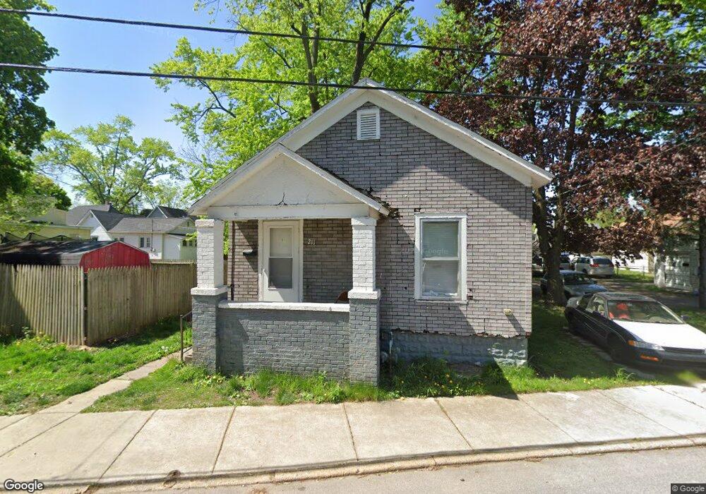
211 S Shore Dr Elkhart, IN 46516
South Shore-Bridge Street NeighborhoodEstimated Value: $67,806 - $158,000
2
Beds
1
Bath
660
Sq Ft
$156/Sq Ft
Est. Value
About This Home
This home is located at 211 S Shore Dr, Elkhart, IN 46516 and is currently estimated at $103,202, approximately $156 per square foot. 211 S Shore Dr is a home located in Elkhart County with nearby schools including Mary Daly Elementary School, West Side Middle School, and Elkhart High School.
Ownership History
Date
Name
Owned For
Owner Type
Purchase Details
Closed on
Jul 27, 2023
Sold by
Ward Lonnie D and Ward Karen S
Bought by
Lonnie D Ward And Karen S Ward Revocable Livi and Ward
Current Estimated Value
Purchase Details
Closed on
Jul 26, 2023
Sold by
Ward Lonnie D and Ward Karen S
Bought by
Lonnie D Ward And Karen S Ward Revocable Livi and Ward
Purchase Details
Closed on
Jun 17, 2013
Sold by
L & K Enterprises Llc
Bought by
Ward Lonnie D and Ward Karen S
Purchase Details
Closed on
Dec 26, 2012
Sold by
Ward Lonnie D and Ward Karen S
Bought by
L & K Enterprises Llc
Purchase Details
Closed on
Jul 16, 2007
Sold by
Ward Lonnie D
Bought by
Ward Lonnie D and Ward Karen S
Purchase Details
Closed on
May 12, 2006
Sold by
Danner Terry Allen
Bought by
Ward Lonnie D
Create a Home Valuation Report for This Property
The Home Valuation Report is an in-depth analysis detailing your home's value as well as a comparison with similar homes in the area
Home Values in the Area
Average Home Value in this Area
Purchase History
| Date | Buyer | Sale Price | Title Company |
|---|---|---|---|
| Lonnie D Ward And Karen S Ward Revocable Livi | -- | None Listed On Document | |
| Lonnie D Ward And Karen S Ward Revocable Livi | -- | None Listed On Document | |
| Ward Lonnie D | -- | None Available | |
| L & K Enterprises Llc | -- | None Available | |
| Ward Lonnie D | -- | None Available | |
| Ward Lonnie D | -- | Metropolitan Title |
Source: Public Records
Tax History Compared to Growth
Tax History
| Year | Tax Paid | Tax Assessment Tax Assessment Total Assessment is a certain percentage of the fair market value that is determined by local assessors to be the total taxable value of land and additions on the property. | Land | Improvement |
|---|---|---|---|---|
| 2024 | $616 | $29,700 | $9,900 | $19,800 |
| 2022 | $616 | $29,700 | $9,900 | $19,800 |
| 2021 | $585 | $28,100 | $9,900 | $18,200 |
| 2020 | $622 | $28,100 | $9,900 | $18,200 |
| 2019 | $484 | $21,800 | $3,600 | $18,200 |
| 2018 | $487 | $21,800 | $3,600 | $18,200 |
| 2017 | $482 | $21,500 | $3,600 | $17,900 |
| 2016 | $480 | $21,500 | $3,600 | $17,900 |
| 2014 | $454 | $21,300 | $3,600 | $17,700 |
| 2013 | $470 | $23,500 | $11,600 | $11,900 |
Source: Public Records
Map
Nearby Homes
- 1301 Harrison St
- 1309 Harrison St
- 1202 S Shore Dr
- 726 W Lexington Ave
- 1007 Mason St
- 124 S Vine St
- 311 Hillside Ct
- 721 Harrison St
- 709 Strong Ave
- 100 S Michigan St
- 607 W Marion St
- 1021 Strong Ave
- 1106 Strong Ave
- 154 N 6th St
- 915 Fulton St
- 419 W High St
- 626 Bower St
- 00000 W Lexington Ave
- 301 W Jackson Blvd
- 302 W Jackson Blvd