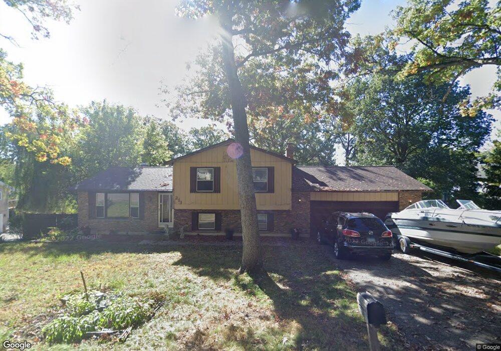
211 Timber Ln Spring Grove, IL 60081
Northwest Fox Lake NeighborhoodEstimated Value: $263,231 - $329,000
3
Beds
--
Bath
1,680
Sq Ft
$178/Sq Ft
Est. Value
About This Home
This home is located at 211 Timber Ln, Spring Grove, IL 60081 and is currently estimated at $299,808, approximately $178 per square foot. 211 Timber Ln is a home located in McHenry County with nearby schools including Spring Grove Elementary School, Nippersink Middle School, and Richmond-Burton High School.
Ownership History
Date
Name
Owned For
Owner Type
Purchase Details
Closed on
Jun 17, 2005
Sold by
Zalesky Joseph
Bought by
Johnson Christopher and Everett Camille A
Current Estimated Value
Home Financials for this Owner
Home Financials are based on the most recent Mortgage that was taken out on this home.
Original Mortgage
$214,470
Outstanding Balance
$111,389
Interest Rate
5.68%
Mortgage Type
FHA
Estimated Equity
$188,419
Purchase Details
Closed on
Mar 24, 2004
Sold by
Haight Joseph
Bought by
Zalesky Joseph
Create a Home Valuation Report for This Property
The Home Valuation Report is an in-depth analysis detailing your home's value as well as a comparison with similar homes in the area
Home Values in the Area
Average Home Value in this Area
Purchase History
| Date | Buyer | Sale Price | Title Company |
|---|---|---|---|
| Johnson Christopher | $214,200 | Attorneys Title Guaranty Fun | |
| Zalesky Joseph | -- | -- |
Source: Public Records
Mortgage History
| Date | Status | Borrower | Loan Amount |
|---|---|---|---|
| Open | Johnson Christopher | $214,470 |
Source: Public Records
Tax History
| Year | Tax Paid | Tax Assessment Tax Assessment Total Assessment is a certain percentage of the fair market value that is determined by local assessors to be the total taxable value of land and additions on the property. | Land | Improvement |
|---|---|---|---|---|
| 2024 | $5,458 | $83,941 | $10,534 | $73,407 |
| 2023 | $5,411 | $78,289 | $9,825 | $68,464 |
| 2022 | $5,131 | $68,868 | $8,643 | $60,225 |
| 2021 | $4,865 | $64,921 | $8,148 | $56,773 |
| 2020 | $4,748 | $62,060 | $7,789 | $54,271 |
| 2019 | $4,780 | $61,095 | $7,668 | $53,427 |
| 2018 | $4,877 | $59,206 | $7,431 | $51,775 |
| 2017 | $4,800 | $55,598 | $6,978 | $48,620 |
| 2016 | $4,812 | $53,097 | $6,664 | $46,433 |
| 2013 | -- | $48,947 | $8,240 | $40,707 |
Source: Public Records
Map
Nearby Homes
- 47 Nassau Colony Unit 1
- 55 Vail Colony Unit 6
- 49 Oak Hill Colony Unit 12
- 11 Saint Thomas Colony Unit 7
- 35 Montego Colony Unit 7
- 63 Aspen Colony Unit 8
- 40 Bermuda Colony Unit 7
- 16 Saint Thomas Colony Unit 6
- 23 Jamaica Colony Unit 5
- 6415 N Shore Ave
- 38265 N State Park Rd
- 7503 Windsor Ave
- 6421 Cherrywood Ct Unit 232
- 530 Main Street Rd
- 535 Deer Run
- 28624 W Kendall Ave
- 7202 Oxford Cir Unit 237
- 7411 Leisure Village Ave Unit 198
- 7105 Saint Tropez Ct Unit 297
- 7302 Chevy Chase Ct Unit 51
- 6802 Normandy Dr
- 6808 Normandy Dr
- 209 Timber Ln
- 212 Coventry Ave
- 208 Coventry Ave
- 218 Coventry Ave
- 212 Timber Ln
- 206 Coventry Ave
- 220 Timber Ln
- 6813 Chillems Dr
- 211 Baron Dr
- 217 Coventry Ave
- 215 Baron Dr
- 202 Coventry Ave
- 219 Coventry Ave
- 6817 Normandy Dr
- 6735 Normandy Dr
- 207 Baron Dr
- 213 Coventry Ave
- 6904 Normandy Dr
Your Personal Tour Guide
Ask me questions while you tour the home.