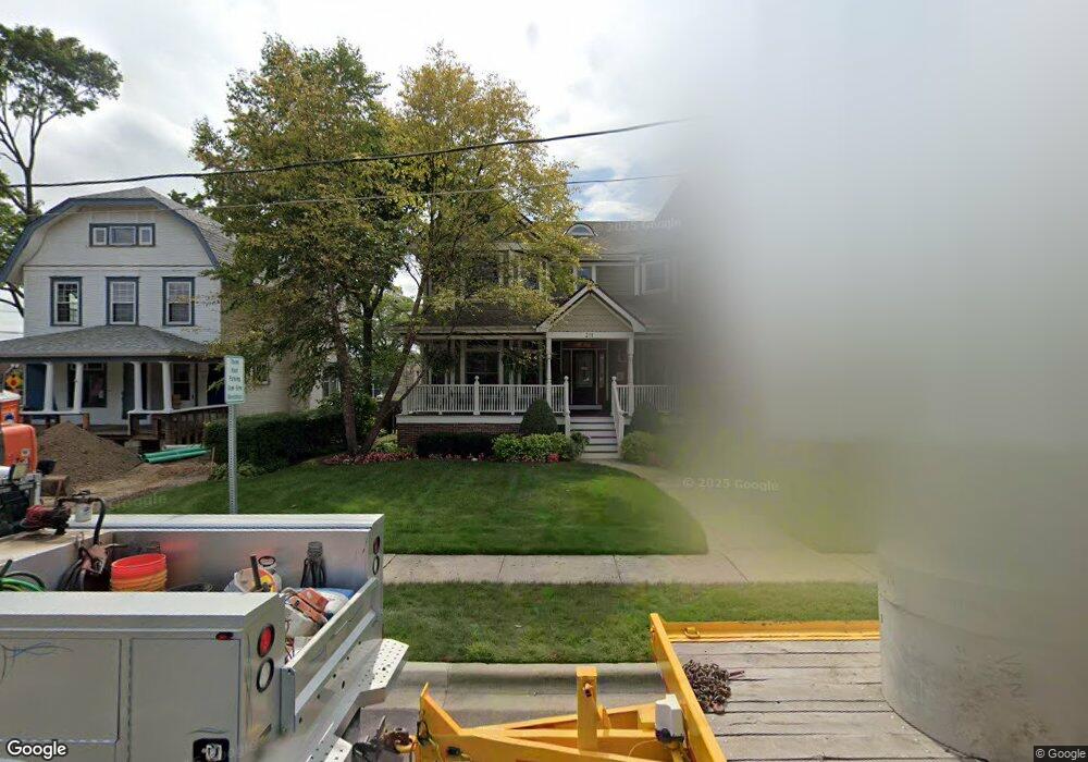
211 W Cook Ave Libertyville, IL 60048
Estimated Value: $1,468,676 - $1,745,000
5
Beds
5
Baths
4,209
Sq Ft
$373/Sq Ft
Est. Value
About This Home
This home is located at 211 W Cook Ave, Libertyville, IL 60048 and is currently estimated at $1,569,669, approximately $372 per square foot. 211 W Cook Ave is a home located in Lake County with nearby schools including Butterfield School, Highland Middle School, and Libertyville High School.
Ownership History
Date
Name
Owned For
Owner Type
Purchase Details
Closed on
Mar 3, 2011
Sold by
Chalifoux Kenneth J and Chalifoux Jennie A
Bought by
Chalifoux Kenneth and Kenneth Chalifoux Trust
Current Estimated Value
Purchase Details
Closed on
Aug 10, 2005
Sold by
Graham Suzanne R
Bought by
Atkinson Builders Llc
Home Financials for this Owner
Home Financials are based on the most recent Mortgage that was taken out on this home.
Original Mortgage
$397,500
Interest Rate
6.25%
Mortgage Type
Purchase Money Mortgage
Create a Home Valuation Report for This Property
The Home Valuation Report is an in-depth analysis detailing your home's value as well as a comparison with similar homes in the area
Home Values in the Area
Average Home Value in this Area
Purchase History
| Date | Buyer | Sale Price | Title Company |
|---|---|---|---|
| Chalifoux Kenneth | -- | None Available | |
| Atkinson Builders Llc | $530,000 | Fatic |
Source: Public Records
Mortgage History
| Date | Status | Borrower | Loan Amount |
|---|---|---|---|
| Closed | Atkinson Builders Llc | $397,500 |
Source: Public Records
Tax History Compared to Growth
Tax History
| Year | Tax Paid | Tax Assessment Tax Assessment Total Assessment is a certain percentage of the fair market value that is determined by local assessors to be the total taxable value of land and additions on the property. | Land | Improvement |
|---|---|---|---|---|
| 2024 | $31,395 | $431,334 | $113,854 | $317,480 |
| 2023 | $30,304 | $397,836 | $105,012 | $292,824 |
| 2022 | $30,304 | $384,915 | $100,933 | $283,982 |
| 2021 | $29,190 | $376,629 | $98,760 | $277,869 |
| 2020 | $28,868 | $380,223 | $97,100 | $283,123 |
| 2019 | $28,148 | $376,608 | $96,177 | $280,431 |
| 2018 | $27,720 | $383,241 | $100,133 | $283,108 |
| 2017 | $27,549 | $371,142 | $96,972 | $274,170 |
| 2016 | $27,944 | $383,819 | $91,943 | $291,876 |
| 2015 | $27,739 | $358,743 | $85,936 | $272,807 |
| 2014 | $25,816 | $319,496 | $80,746 | $238,750 |
| 2012 | $24,965 | $326,924 | $78,314 | $248,610 |
Source: Public Records
Map
Nearby Homes
- 212 Elm Ct
- 505 Lange Ct
- 420 W Cook Ave
- 217 E Church St
- 224 Newberry Ave
- 308 Mckinley Ave
- 922 N Milwaukee Ave Unit A
- 212 W Ellis Ave
- 208 W Ellis Ave
- 204 W Ellis Ave
- 551 W Park Ave Unit E
- 619 Parkside Ct
- 1754 Glenmore Rd
- 616 Parkside Ct
- 662 Parkside Ct
- 694 Parkside Ct
- 1211 Parliament Ct
- 112 3rd St
- 423 Ames St
- 601 Broadway St
- 205 W Cook Ave
- 215 W Cook Ave
- 212 W Cook Ave
- 206 W Cook Ave
- 216 W Cook Ave
- 224 W Cook Ave
- 300 Laurel Ave
- 234 W Cook Ave
- 234A W Cook Ave
- 523 Brainerd Ave
- 301 Laurel Ave
- 517 Brainerd Ave
- 517 Brainerd Ave
- 304 W Cook Ave
- 304 W Cook Ave
- 527 Brainerd Ave
- 307 W Cook Ave
- 309 W Cook Ave
- 216 Elm Ct
- 303 Laurel Ave