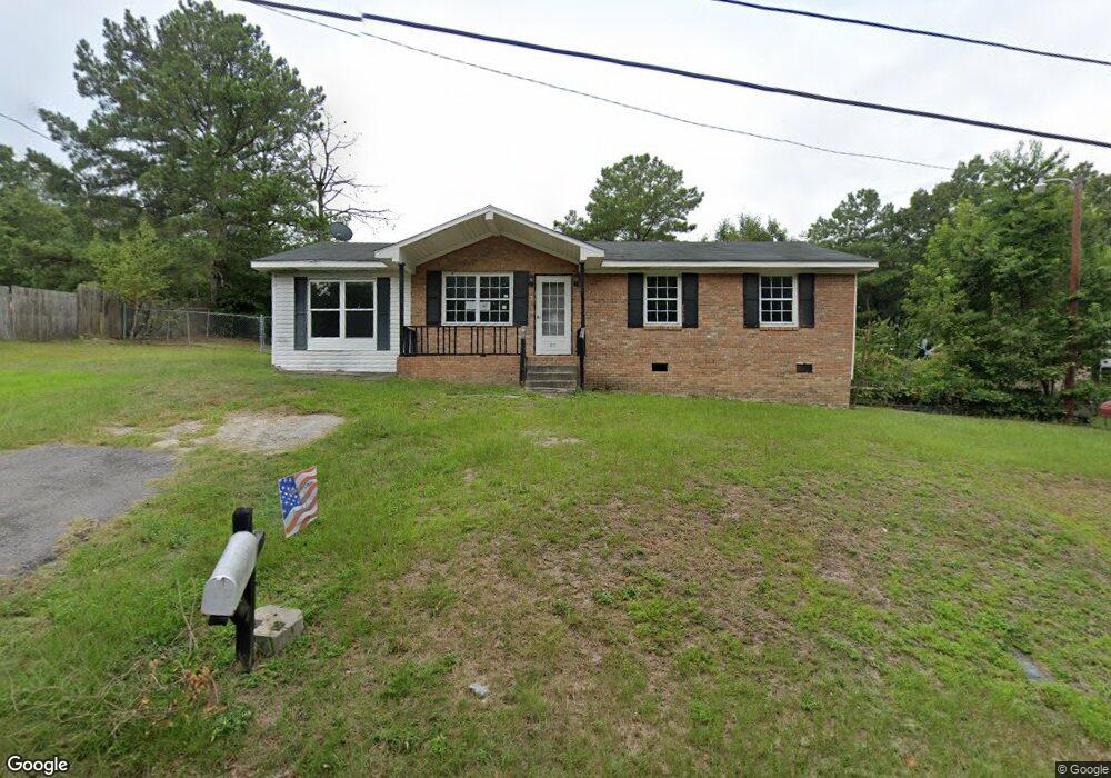
211 Weir Dr Columbia, SC 29223
Dentsville NeighborhoodEstimated Value: $86,000 - $182,928
3
Beds
1
Bath
1,458
Sq Ft
$94/Sq Ft
Est. Value
About This Home
This home is located at 211 Weir Dr, Columbia, SC 29223 and is currently estimated at $136,982, approximately $93 per square foot. 211 Weir Dr is a home located in Richland County with nearby schools including Windsor Elementary School, E. L. Wright Middle School, and Westwood High School.
Ownership History
Date
Name
Owned For
Owner Type
Purchase Details
Closed on
Nov 22, 2019
Sold by
Us Bank Na
Bought by
Ann Guzman Priscilla
Current Estimated Value
Purchase Details
Closed on
Jan 25, 2019
Sold by
Motley Tiajuana and Motley Amarious
Bought by
U S Bank Na and Truman 2016 Sc6 Title Trust
Purchase Details
Closed on
Jul 28, 2006
Sold by
Fannie Mae
Bought by
Motley Kareem
Purchase Details
Closed on
Oct 18, 2005
Sold by
Willock Marie A
Bought by
Federal National Mortgage Association
Purchase Details
Closed on
Aug 2, 1998
Sold by
Cox Willock Marie A
Bought by
Willock Marie A
Create a Home Valuation Report for This Property
The Home Valuation Report is an in-depth analysis detailing your home's value as well as a comparison with similar homes in the area
Home Values in the Area
Average Home Value in this Area
Purchase History
| Date | Buyer | Sale Price | Title Company |
|---|---|---|---|
| Ann Guzman Priscilla | $42,500 | None Available | |
| U S Bank Na | $40,000 | None Available | |
| Motley Kareem | -- | None Available | |
| Federal National Mortgage Association | $40,000 | -- | |
| Willock Marie A | -- | -- |
Source: Public Records
Tax History Compared to Growth
Tax History
| Year | Tax Paid | Tax Assessment Tax Assessment Total Assessment is a certain percentage of the fair market value that is determined by local assessors to be the total taxable value of land and additions on the property. | Land | Improvement |
|---|---|---|---|---|
| 2024 | $1,932 | $48,900 | $0 | $0 |
| 2023 | $1,932 | $1,700 | $0 | $0 |
| 2022 | $1,766 | $42,500 | $4,000 | $38,500 |
| 2021 | $1,747 | $2,550 | $0 | $0 |
| 2020 | $1,753 | $2,550 | $0 | $0 |
| 2019 | $2,082 | $3,190 | $0 | $0 |
| 2018 | $1,837 | $2,780 | $0 | $0 |
| 2017 | $1,795 | $2,780 | $0 | $0 |
| 2016 | $1,787 | $2,780 | $0 | $0 |
| 2015 | $1,741 | $2,780 | $0 | $0 |
| 2014 | $1,721 | $46,300 | $0 | $0 |
| 2013 | -- | $2,780 | $0 | $0 |
Source: Public Records
Map
Nearby Homes
- 316 Todd Branch Dr
- 224 Todd Branch Dr
- 6230 Two Notch Rd
- 109 Travers Ln
- 8824 Two Notch Rd
- 9429 S Chelsea Rd
- 216 Rabon Rd
- 132 Greengate Dr
- 3090 Appleby Ln
- 2927 Cranbrook Ln
- 2901 Woodway Ln
- 11 Royalgate Dr
- 3002 Woodway Ln
- 3040 Kilkee Cir
- 3016 Chipping Ln
- N/S Rabon Rd
- W/S Rabon Rd
- 116 Carr Ln
- 120 Carr Ln
- 4 Chesapeake Ct
- 1069 Matchingham Dr
- 1062 Matchingham Dr
- 1068 Matchingham Dr
- 1074 Matchingham Dr
- 1070 Matchingham Dr
- 1076 Matchingham Dr
- 1064 Matchingham Dr
- 1061 Matchingham Dr
- 1058 Matchingham Dr
- 1083 Matchingham Dr
- 1081 Matchingham Dr
- 1077 Matchingham Dr
- 1075 Matchingham Dr
- 1065 Matchingham Dr
- 1071 Matchingham Dr
- 1049 Matchingham Dr
- 1087 Matchingham Dr
- 1063 Matchingham Dr
- 1003 Matchingham Dr
- 1022 Matchingham Dr