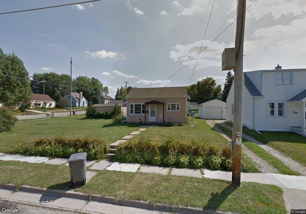
211 William St Watertown, WI 53094
Estimated Value: $141,000 - $325,000
--
Bed
--
Bath
--
Sq Ft
7,754
Sq Ft Lot
About This Home
This home is located at 211 William St, Watertown, WI 53094 and is currently estimated at $194,990. 211 William St is a home located in Jefferson County with nearby schools including Watertown High School, eCampus Academy Charter School, and Trinity-St. Luke's Lutheran Elementary School.
Ownership History
Date
Name
Owned For
Owner Type
Purchase Details
Closed on
Dec 28, 2006
Sold by
Maahs David A and Busch Debra K
Bought by
Liebhart William T and Liebhart Nancy J
Current Estimated Value
Home Financials for this Owner
Home Financials are based on the most recent Mortgage that was taken out on this home.
Original Mortgage
$55,000
Outstanding Balance
$32,923
Interest Rate
6.24%
Mortgage Type
Purchase Money Mortgage
Estimated Equity
$162,067
Create a Home Valuation Report for This Property
The Home Valuation Report is an in-depth analysis detailing your home's value as well as a comparison with similar homes in the area
Home Values in the Area
Average Home Value in this Area
Purchase History
| Date | Buyer | Sale Price | Title Company |
|---|---|---|---|
| Liebhart William T | $45,000 | Gatewood Title Services |
Source: Public Records
Mortgage History
| Date | Status | Borrower | Loan Amount |
|---|---|---|---|
| Open | Liebhart William T | $55,000 |
Source: Public Records
Tax History Compared to Growth
Tax History
| Year | Tax Paid | Tax Assessment Tax Assessment Total Assessment is a certain percentage of the fair market value that is determined by local assessors to be the total taxable value of land and additions on the property. | Land | Improvement |
|---|---|---|---|---|
| 2024 | $1,520 | $104,300 | $44,200 | $60,100 |
| 2023 | $1,391 | $80,600 | $38,200 | $42,400 |
| 2022 | $1,395 | $80,600 | $38,200 | $42,400 |
| 2021 | $1,269 | $51,400 | $22,500 | $28,900 |
| 2020 | $1,256 | $51,400 | $22,500 | $28,900 |
| 2019 | $1,226 | $51,400 | $22,500 | $28,900 |
| 2018 | $1,192 | $51,400 | $22,500 | $28,900 |
| 2017 | $1,132 | $51,400 | $22,500 | $28,900 |
| 2016 | $1,118 | $51,400 | $22,500 | $28,900 |
| 2015 | $1,105 | $51,400 | $22,500 | $28,900 |
| 2014 | $1,119 | $51,400 | $22,500 | $28,900 |
| 2013 | $1,139 | $51,400 | $22,500 | $28,900 |
Source: Public Records
Map
Nearby Homes
- 1301 Utah St
- 1215 Utah St
- 1313 Utah St
- 1314 Waldron St
- 913 S 3rd St
- 1418 S 9th St
- 131 Cedar Ct
- The Saybrook Plan at Rock River Ridge
- The Atwater Plan at Rock River Ridge
- The Hudson Plan at Rock River Ridge
- The Coral Plan at Rock River Ridge
- The Drake Plan at Rock River Ridge
- The Addison Plan at Rock River Ridge
- The Bradford Plan at Rock River Ridge
- The Catalina Plan at Rock River Ridge
- The Adrian Plan at Rock River Ridge
- The McKinley Plan at Rock River Ridge
- The Siena Plan at Rock River Ridge
- The Bridgeport Plan at Rock River Ridge
- The Wingra Plan at Rock River Ridge