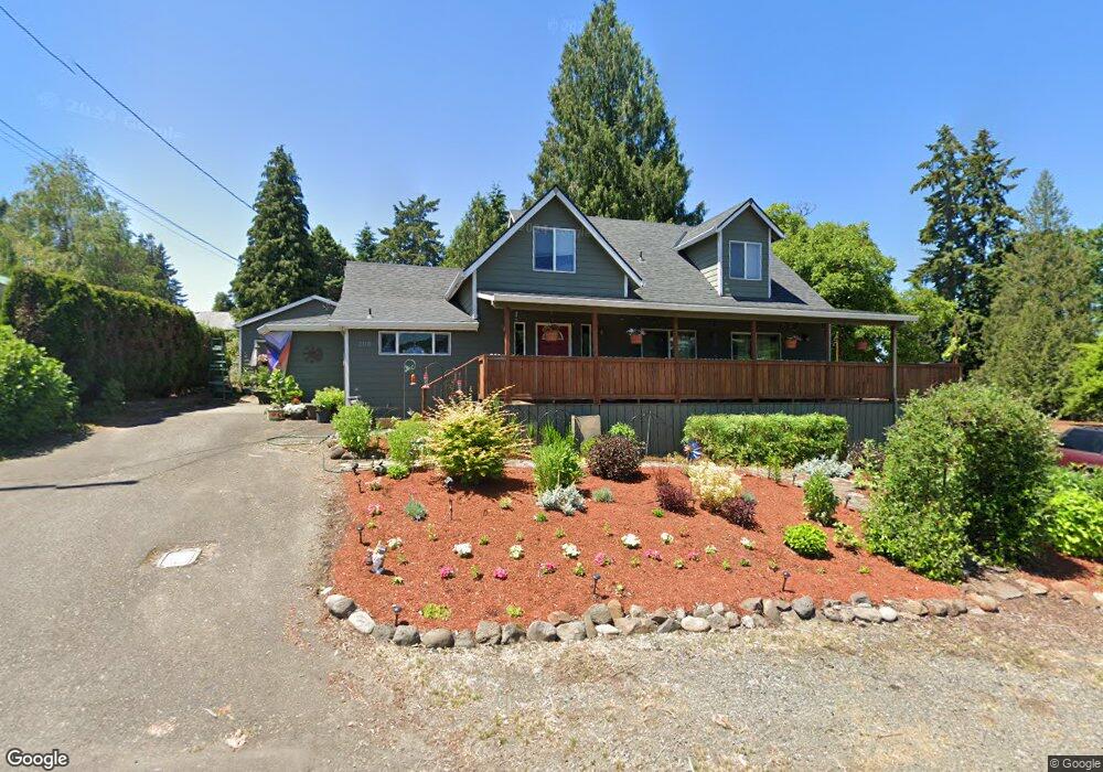
2110 16th St West Linn, OR 97068
Willamette NeighborhoodEstimated Value: $620,038 - $697,000
3
Beds
3
Baths
2,259
Sq Ft
$290/Sq Ft
Est. Value
About This Home
This home is located at 2110 16th St, West Linn, OR 97068 and is currently estimated at $656,010, approximately $290 per square foot. 2110 16th St is a home located in Clackamas County with nearby schools including Willamette Primary School, Athey Creek Middle School, and West Linn High School.
Ownership History
Date
Name
Owned For
Owner Type
Purchase Details
Closed on
Oct 22, 2007
Sold by
Mcdevitt Thomas
Bought by
Mcdevitt Thomas and Mcdevitt Inga
Current Estimated Value
Home Financials for this Owner
Home Financials are based on the most recent Mortgage that was taken out on this home.
Original Mortgage
$170,000
Outstanding Balance
$105,966
Interest Rate
6.27%
Mortgage Type
New Conventional
Estimated Equity
$550,044
Purchase Details
Closed on
Sep 16, 2002
Sold by
Thomsen Thomas L
Bought by
Mcdevitt Thomas
Home Financials for this Owner
Home Financials are based on the most recent Mortgage that was taken out on this home.
Original Mortgage
$135,000
Interest Rate
6.24%
Purchase Details
Closed on
Feb 15, 2000
Sold by
Trask Brenda G
Bought by
Norwest Bank Minnesota Na and Salomon Brothers Mtg Securities Vii Inc
Create a Home Valuation Report for This Property
The Home Valuation Report is an in-depth analysis detailing your home's value as well as a comparison with similar homes in the area
Home Values in the Area
Average Home Value in this Area
Purchase History
| Date | Buyer | Sale Price | Title Company |
|---|---|---|---|
| Mcdevitt Thomas | -- | Lawyers Title Ins | |
| Mcdevitt Thomas | $215,000 | Pacific Nw Title | |
| Norwest Bank Minnesota Na | $134,632 | Transnation Title Insurance |
Source: Public Records
Mortgage History
| Date | Status | Borrower | Loan Amount |
|---|---|---|---|
| Open | Mcdevitt Thomas | $170,000 | |
| Closed | Mcdevitt Thomas | $135,000 | |
| Closed | Mcdevitt Thomas | $50,000 |
Source: Public Records
Tax History Compared to Growth
Tax History
| Year | Tax Paid | Tax Assessment Tax Assessment Total Assessment is a certain percentage of the fair market value that is determined by local assessors to be the total taxable value of land and additions on the property. | Land | Improvement |
|---|---|---|---|---|
| 2025 | $5,300 | $275,008 | -- | -- |
| 2024 | $5,102 | $266,999 | -- | -- |
| 2023 | $5,102 | $259,223 | $0 | $0 |
| 2022 | $4,815 | $251,673 | $0 | $0 |
| 2021 | $4,571 | $244,343 | $0 | $0 |
| 2020 | $4,602 | $237,227 | $0 | $0 |
| 2019 | $4,389 | $230,318 | $0 | $0 |
| 2018 | $4,193 | $223,610 | $0 | $0 |
| 2017 | $4,030 | $217,097 | $0 | $0 |
| 2016 | $3,926 | $210,774 | $0 | $0 |
| 2015 | $3,657 | $204,635 | $0 | $0 |
| 2014 | $3,485 | $198,675 | $0 | $0 |
Source: Public Records
Map
Nearby Homes
- 1733 Jamie Cir
- 2026 Virginia Ln
- 1925 Hillhouse Dr
- 1925 16th St
- 1791 Blankenship Rd
- 850 Springtree Ln Unit 850
- 1931 13th St
- 640 Springtree Ln
- 1721 Dollar St Unit 1721
- 1160 Blankenship Rd
- 3565 Summerlinn Dr Unit 64
- 3850 Summerlinn Dr Unit 58
- 4630 Summerlinn Way
- 4650 Summerlinn Way
- 2240 Snowberry Ridge Ct Unit 2240
- 3395 Summerlinn Dr Unit 24
- 1694 16th St
- 1690 16th St
- 3135 Summerlinn Dr Unit 40
- 6505 Summerlinn Way Unit 79