Estimated Value: $454,588 - $546,000
4
Beds
2
Baths
2,234
Sq Ft
$219/Sq Ft
Est. Value
About This Home
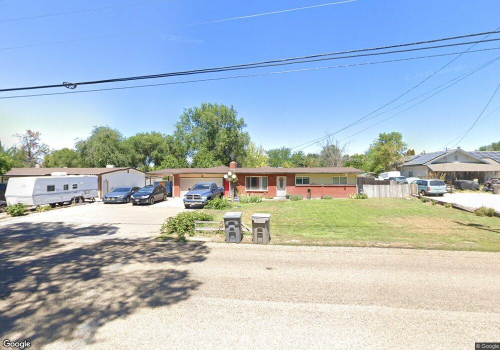
This home is located at 2110 E Greenhurst Rd, Nampa, ID 83686 and is currently estimated at $488,397, approximately $218 per square foot. 2110 E Greenhurst Rd is a home located in Canyon County with nearby schools including Greenhurst Elementary School, South Middle School, and Skyview High School.
Ownership History
Date
Name
Owned For
Owner Type
Purchase Details
Closed on
May 19, 2009
Sold by
Deutsche Bank Trust Company Americas
Bought by
Sorger Frank J and The Frank J Sorger Jr Heritage Trust
Current Estimated Value
Purchase Details
Closed on
May 2, 2008
Sold by
Haro Francisco C and Haro Louise M
Bought by
Deutsche Bank Trust Co Americas and Morgan Stanley Abs Capital I Inc Msac 20
Purchase Details
Closed on
May 12, 2005
Sold by
Rigenhagen Richard D and Rigenhagen Carol J
Bought by
Haro Francisco C and Haro Louise M
Home Financials for this Owner
Home Financials are based on the most recent Mortgage that was taken out on this home.
Original Mortgage
$138,050
Interest Rate
6.02%
Mortgage Type
FHA
Create a Home Valuation Report for This Property
The Home Valuation Report is an in-depth analysis detailing your home's value as well as a comparison with similar homes in the area
Home Values in the Area
Average Home Value in this Area
Purchase History
| Date | Buyer | Sale Price | Title Company |
|---|---|---|---|
| Sorger Frank J | -- | Pioneer Title Company | |
| Deutsche Bank Trust Co Americas | $151,725 | Pioneer Title Company | |
| Haro Francisco C | -- | Pioneer Title Company Of Can |
Source: Public Records
Mortgage History
| Date | Status | Borrower | Loan Amount |
|---|---|---|---|
| Previous Owner | Haro Francisco C | $138,050 |
Source: Public Records
Tax History Compared to Growth
Tax History
| Year | Tax Paid | Tax Assessment Tax Assessment Total Assessment is a certain percentage of the fair market value that is determined by local assessors to be the total taxable value of land and additions on the property. | Land | Improvement |
|---|---|---|---|---|
| 2025 | $1,812 | $428,600 | $173,300 | $255,300 |
| 2024 | $1,812 | $427,900 | $173,300 | $254,600 |
| 2023 | $1,882 | $414,900 | $173,300 | $241,600 |
| 2022 | $2,000 | $455,900 | $190,600 | $265,300 |
| 2021 | $2,603 | $344,500 | $120,700 | $223,800 |
| 2020 | $2,687 | $288,300 | $93,000 | $195,300 |
| 2019 | $2,810 | $258,800 | $74,500 | $184,300 |
| 2018 | $2,710 | $0 | $0 | $0 |
| 2017 | $2,690 | $0 | $0 | $0 |
| 2016 | $2,057 | $0 | $0 | $0 |
| 2015 | $1,776 | $0 | $0 | $0 |
| 2014 | $1,685 | $135,800 | $37,000 | $98,800 |
Source: Public Records
Map
Nearby Homes
- 2019 Kentucky Dr
- 1835 E Kentucky Ave
- 2622 Boulder Ave
- 1426 Chicago St
- 1801 E Iowa Ave
- 2714 S Almond Ct
- 2912 E Iowa Ave
- 946 S Almond Ct
- 945 S Almond Ct
- 3601 S Angel Falls Way
- 2040 W Ibis Dr
- 3630 S Angel Falls Way
- 7232 E Merlin Hawk Ct
- 11623 W Black Dog Dr
- 1612 E York Ave
- 1921 E Explorer Ct
- 2308 E Elm Grove Dr
- 2020 E Lost River Ave
- 2121 Lambert Dr
- 1157 S Powerline Rd
- 2114 E Greenhurst Rd
- 2102 E Greenhurst Rd
- 2118 E Greenhurst Rd
- 0 Ventura Dr
- 2109 Belle Aire Dr
- 2117 Belle Aire Dr
- 2203 S Chicago Ave
- 2203 S Chicago Ave
- 2214 Ventura Dr
- 2229 Ventura Dr
- 2105 Belle Aire Dr
- 2115 E Greenhurst Rd
- 0 Chicago St
- 2121 S Chicago Ave
- 2215 Ventura Dr
- 2101 Belle Aire Dr
- 2212 S Chicago Ave
- 2220 S Chicago Ave
- 2207 E Greenhurst Rd
- 2206 S Chicago Ave