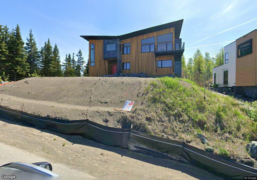
2110 Mckenzie Dr Anchorage, AK 99517
Turnagain NeighborhoodEstimated Value: $430,000 - $1,090,855
4
Beds
3
Baths
3,272
Sq Ft
$232/Sq Ft
Est. Value
About This Home
This home is located at 2110 Mckenzie Dr, Anchorage, AK 99517 and is currently estimated at $760,428, approximately $232 per square foot. 2110 Mckenzie Dr is a home with nearby schools including Turnagain Elementary School, Romig Middle School, and West High School.
Ownership History
Date
Name
Owned For
Owner Type
Purchase Details
Closed on
Feb 6, 2025
Sold by
Miner James E and Miner Mary E
Bought by
Miner James and Miner Mary
Current Estimated Value
Home Financials for this Owner
Home Financials are based on the most recent Mortgage that was taken out on this home.
Original Mortgage
$1,800,000
Outstanding Balance
$1,782,798
Interest Rate
6.85%
Mortgage Type
New Conventional
Estimated Equity
-$1,022,370
Purchase Details
Closed on
Jun 23, 2023
Sold by
Miner James E
Bought by
Miner James E and Miner Mary E
Purchase Details
Closed on
Oct 13, 2021
Sold by
Municipality Of Anchorage
Bought by
Miner James E
Home Financials for this Owner
Home Financials are based on the most recent Mortgage that was taken out on this home.
Original Mortgage
$3,700,000
Interest Rate
2.8%
Mortgage Type
New Conventional
Purchase Details
Closed on
Apr 10, 2018
Sold by
Beal David D and Beal Trust
Bought by
Beal David D
Home Financials for this Owner
Home Financials are based on the most recent Mortgage that was taken out on this home.
Interest Rate
4.4%
Purchase Details
Closed on
Jul 1, 2010
Sold by
Hardley Sabrina J
Bought by
The Beal Family Trust
Purchase Details
Closed on
Feb 4, 2005
Sold by
Beal Md David D
Bought by
Hartley Sabrina J
Create a Home Valuation Report for This Property
The Home Valuation Report is an in-depth analysis detailing your home's value as well as a comparison with similar homes in the area
Home Values in the Area
Average Home Value in this Area
Purchase History
| Date | Buyer | Sale Price | Title Company |
|---|---|---|---|
| Miner James | -- | None Listed On Document | |
| Miner James E | -- | None Listed On Document | |
| Miner James E | -- | None Listed On Document | |
| Beal David D | -- | -- | |
| The Beal Family Trust | -- | None Available | |
| Hartley Sabrina J | -- | -- |
Source: Public Records
Mortgage History
| Date | Status | Borrower | Loan Amount |
|---|---|---|---|
| Open | Miner James | $1,800,000 | |
| Previous Owner | Miner James E | $3,700,000 | |
| Previous Owner | Beal David D | -- |
Source: Public Records
Tax History
| Year | Tax Paid | Tax Assessment Tax Assessment Total Assessment is a certain percentage of the fair market value that is determined by local assessors to be the total taxable value of land and additions on the property. | Land | Improvement |
|---|---|---|---|---|
| 2025 | $6,082 | $874,700 | $132,900 | $741,800 |
| 2024 | $6,082 | $376,700 | $132,900 | $243,800 |
| 2023 | $2,395 | $132,900 | $132,900 | $0 |
| 2022 | $2,238 | $132,900 | $132,900 | $0 |
| 2021 | $2,427 | $134,700 | $134,700 | $0 |
| 2020 | $2,290 | $134,700 | $134,700 | $0 |
| 2019 | $2,204 | $134,700 | $134,700 | $0 |
| 2018 | $2,035 | $124,100 | $124,100 | $0 |
| 2017 | $1,829 | $116,800 | $116,800 | $0 |
| 2016 | $1,467 | $106,500 | $106,500 | $0 |
| 2015 | $1,467 | $94,400 | $94,400 | $0 |
| 2014 | $1,467 | $94,200 | $94,200 | $0 |
Source: Public Records
Map
Nearby Homes
- 2401 W Marston Dr
- 000 Chilligan Dr
- 2934 Marston Dr
- 2335 Lord Baranof Dr
- 2540 Lord Baranof Dr
- 4111 Woronzof Dr
- 2921 W 29th Ave Unit 5B
- 2906 W 29th Ave
- 3171 Horizon St
- 2140 Atwood Dr
- 2543 La Honda Dr Unit 7
- 2064 Belair Dr
- Tr A W Northern Lights Blvd
- 3240 Wiley Post Loop
- 3517 Vintage Cir
- 2201 Belmont Dr
- 1936 Wildwood Ln
- 2511 Abbey Ln
- 1854 Buccaneer Place Unit 1854
- 1435 W 25th Ave
- 3536 Illiamna Ave
- 2125 W Marston Dr
- 2114 Mckenzie Dr
- L10 BC W Marston Dr
- L9 BC W Marston Dr
- 000 W Marston Dr
- 2 Lots W Marston Dr
- 2140 W Marston Dr
- 2157 W Marston Dr
- 3414 Illiamna Ave
- 3431 Illiamna Ave
- 2119 Mckenzie Dr
- 2128 W Marston Dr
- 2100 W Marston Dr
- 2131 Mckenzie Dr
- 2225 Tulik Dr
- 2171 W Marston Dr
- 2143 Mckenzie Dr
- 3411 Illiamna Ave
- 2200 Mckenzie Dr
Your Personal Tour Guide
Ask me questions while you tour the home.