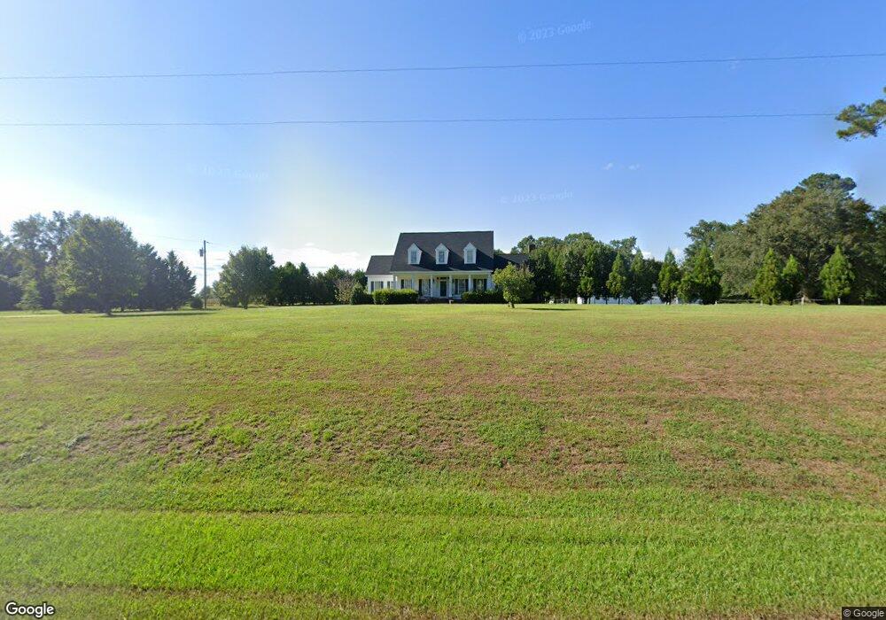
2110 Newton Grove Hwy Newton Grove, NC 28366
Estimated Value: $236,000 - $315,302
3
Beds
3
Baths
1,950
Sq Ft
$139/Sq Ft
Est. Value
About This Home
This home is located at 2110 Newton Grove Hwy, Newton Grove, NC 28366 and is currently estimated at $271,076, approximately $139 per square foot. 2110 Newton Grove Hwy is a home located in Sampson County with nearby schools including Hobbton Elementary School, Hobbton Middle School, and Hobbton High School.
Ownership History
Date
Name
Owned For
Owner Type
Purchase Details
Closed on
Mar 8, 2012
Sold by
Branch Banking And Trust Co
Bought by
Jackson Lydia and Jackson Robert
Current Estimated Value
Home Financials for this Owner
Home Financials are based on the most recent Mortgage that was taken out on this home.
Original Mortgage
$107,211
Outstanding Balance
$73,223
Interest Rate
3.75%
Mortgage Type
FHA
Estimated Equity
$197,853
Create a Home Valuation Report for This Property
The Home Valuation Report is an in-depth analysis detailing your home's value as well as a comparison with similar homes in the area
Home Values in the Area
Average Home Value in this Area
Purchase History
| Date | Buyer | Sale Price | Title Company |
|---|---|---|---|
| Jackson Lydia | $110,000 | None Available |
Source: Public Records
Mortgage History
| Date | Status | Borrower | Loan Amount |
|---|---|---|---|
| Open | Jackson Lydia | $107,211 |
Source: Public Records
Tax History Compared to Growth
Tax History
| Year | Tax Paid | Tax Assessment Tax Assessment Total Assessment is a certain percentage of the fair market value that is determined by local assessors to be the total taxable value of land and additions on the property. | Land | Improvement |
|---|---|---|---|---|
| 2025 | $2,081 | $273,866 | $18,803 | $255,063 |
| 2024 | $1,876 | $273,866 | $18,803 | $255,063 |
| 2023 | $1,585 | $176,135 | $16,350 | $159,785 |
| 2022 | $1,585 | $176,135 | $16,350 | $159,785 |
| 2021 | $1,585 | $176,135 | $16,350 | $159,785 |
| 2020 | $1,585 | $176,135 | $16,350 | $159,785 |
| 2019 | $1,585 | $176,135 | $0 | $0 |
| 2018 | $1,494 | $166,055 | $0 | $0 |
| 2017 | $1,478 | $166,055 | $0 | $0 |
| 2016 | $1,486 | $166,055 | $0 | $0 |
| 2015 | $1,486 | $166,055 | $0 | $0 |
| 2014 | $1,538 | $171,815 | $0 | $0 |
Source: Public Records
Map
Nearby Homes
- 520 Fayetteville St
- 3092 Harnett-Dunn Hwy
- 352 Old Crow Rd
- 0 Hobbton Hwy Unit 100510708
- 10455 U S 701 Hwy
- 00 Trail End Ln
- 00 Trail End Ln Unit LotWP001
- 0 Main St
- 410 E Barefoot Rd
- 1676 Smithfield Hwy
- 636 Tart Town Rd
- 13015 Hobbton Hwy
- Tract 1 Tart Town Rd
- Tract One Tart Town Rd
- 267 Ed Collins Ln
- 1509 Sampson Acres Dr
- 762 Share Cake Rd
- 88 Holiday Ln
- 904 Langston Rd
- 445 Bud Johnson Rd
- 2117 Newton Grove Hwy
- 2150 Newton Grove Hwy
- 1839 Newton Grove Hwy
- 2439 Newton Grove Hwy
- 2475 Newton Grove Hwy
- 0 Captain Westbrook Rd
- 2530 Newton Grove Hwy
- 2316 Warren Mill Rd
- 0 Warren Mill Rd
- 2600 Newton Grove Hwy
- 2540 Warren Mill Rd
- 2530 Warren Mill Rd
- 2116 Warren Mill Rd
- 2680 Warren Mill Rd
- 795 Isham Rd
- 225 Rossie Ln
- 1684 Warren Mill Rd
- 449 Bells Branch Rd
- 2775 Warren Mill Rd
- 1535 Warren Mill Rd