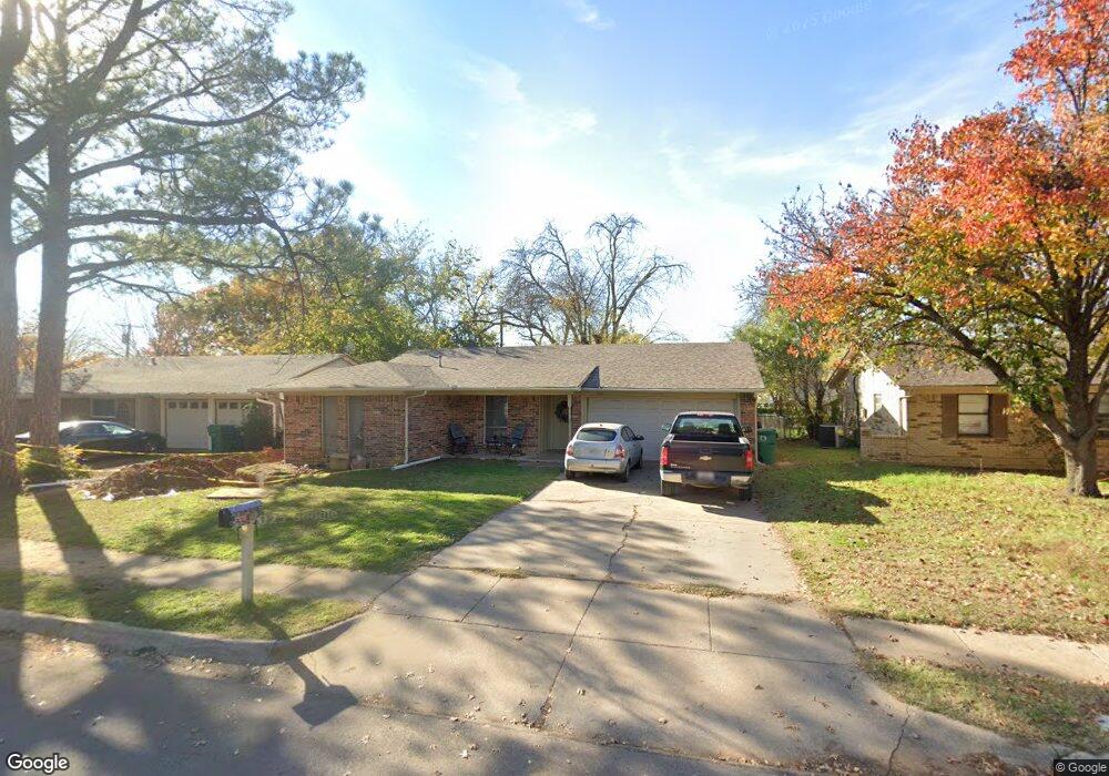
2110 Westwood Dr Denton, TX 76205
Denia NeighborhoodEstimated Value: $259,332 - $301,000
3
Beds
2
Baths
1,215
Sq Ft
$231/Sq Ft
Est. Value
About This Home
This home is located at 2110 Westwood Dr, Denton, TX 76205 and is currently estimated at $280,583, approximately $230 per square foot. 2110 Westwood Dr is a home located in Denton County with nearby schools including Borman Elementary School, McMath Middle School, and Denton High School.
Ownership History
Date
Name
Owned For
Owner Type
Purchase Details
Closed on
Nov 19, 1996
Sold by
Gentry Arthur Morris and Gentry Asa Morris
Bought by
Smith Randy L and Smith Audra J
Current Estimated Value
Home Financials for this Owner
Home Financials are based on the most recent Mortgage that was taken out on this home.
Original Mortgage
$68,916
Outstanding Balance
$6,678
Interest Rate
7.9%
Mortgage Type
FHA
Estimated Equity
$273,905
Create a Home Valuation Report for This Property
The Home Valuation Report is an in-depth analysis detailing your home's value as well as a comparison with similar homes in the area
Home Values in the Area
Average Home Value in this Area
Purchase History
| Date | Buyer | Sale Price | Title Company |
|---|---|---|---|
| Smith Randy L | -- | -- |
Source: Public Records
Mortgage History
| Date | Status | Borrower | Loan Amount |
|---|---|---|---|
| Open | Smith Randy L | $68,916 |
Source: Public Records
Tax History Compared to Growth
Tax History
| Year | Tax Paid | Tax Assessment Tax Assessment Total Assessment is a certain percentage of the fair market value that is determined by local assessors to be the total taxable value of land and additions on the property. | Land | Improvement |
|---|---|---|---|---|
| 2025 | $4,517 | $222,000 | $55,800 | $166,200 |
| 2024 | $4,517 | $234,000 | $55,800 | $178,200 |
| 2023 | $5,175 | $271,033 | $55,800 | $215,233 |
| 2022 | $4,876 | $229,687 | $55,800 | $173,887 |
| 2021 | $3,742 | $168,307 | $37,200 | $131,107 |
| 2020 | $3,718 | $162,657 | $37,200 | $125,457 |
| 2019 | $3,531 | $148,000 | $37,200 | $110,800 |
| 2018 | $3,037 | $125,703 | $37,200 | $88,503 |
| 2017 | $3,076 | $124,462 | $35,340 | $89,122 |
| 2016 | $2,348 | $95,000 | $22,320 | $72,680 |
| 2015 | $2,027 | $85,000 | $22,320 | $62,680 |
| 2013 | -- | $83,916 | $26,040 | $57,876 |
Source: Public Records
Map
Nearby Homes
- 2302 Mercedes Rd
- 2314 Leslie St
- 2421 Mercedes Rd
- 1523 Oakwood Dr
- 1619 Mccormick St
- 631 Acme St
- 2216 Redwing Dr
- 1211 Lindsey St
- 2305 Bernard St
- 2605 Mccormick St
- 2609 Mccormick St
- 2321 Ruff Rd
- 2216 Ruff Rd
- 2617 Mccormick St
- 2700 Mccormick St
- 2621 Mccormick St
- 2513 Goldfinch Dr
- 2708 Mccormick St
- 2512 Goldfinch Dr
- 2800 Mccormick St
- 2106 Westwood Dr
- 2114 Westwood Dr
- 2111 Mccormick St
- 2102 Westwood Dr
- 2118 Westwood Dr
- 2107 Mccormick St
- 2115 Mccormick St
- 2111 Westwood Dr
- 2103 Mccormick St
- 2119 Mccormick St
- 2115 Westwood Dr
- 2107 Westwood Dr
- 2022 Westwood Dr
- 2119 Westwood Dr
- 2103 Westwood Dr
- 2023 Mccormick St
- 2018 Westwood Dr
- 2023 Westwood Dr
- 2202 Westwood Dr
- 2019 Mccormick St