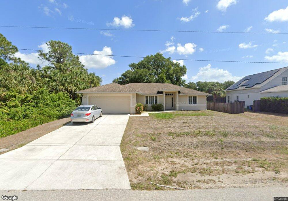
2110 Wheeling Ave North Port, FL 34288
Estimated Value: $288,149 - $362,000
3
Beds
2
Baths
1,778
Sq Ft
$181/Sq Ft
Est. Value
About This Home
This home is located at 2110 Wheeling Ave, North Port, FL 34288 and is currently estimated at $322,537, approximately $181 per square foot. 2110 Wheeling Ave is a home located in Sarasota County with nearby schools including Atwater Elementary School, North Port High School, and Woodland Middle School.
Ownership History
Date
Name
Owned For
Owner Type
Purchase Details
Closed on
May 7, 2018
Sold by
Forlano Carlo and Forlano Angelina
Bought by
Caf Rentals Holdings Llc
Current Estimated Value
Purchase Details
Closed on
Apr 21, 2005
Sold by
Stacy Charles J and Stacy Dana R
Bought by
Forlano Carlo and Forlano Angelina
Purchase Details
Closed on
Dec 19, 1997
Sold by
Scrutiny Inc
Bought by
Howard David
Purchase Details
Closed on
Sep 16, 1997
Sold by
Clerk Circuit Court
Bought by
Scrutiny Inc
Purchase Details
Closed on
Jul 12, 1993
Sold by
Nationsbank Fl
Bought by
Ravello Irvin C and Ravello Anthony E
Create a Home Valuation Report for This Property
The Home Valuation Report is an in-depth analysis detailing your home's value as well as a comparison with similar homes in the area
Home Values in the Area
Average Home Value in this Area
Purchase History
| Date | Buyer | Sale Price | Title Company |
|---|---|---|---|
| Caf Rentals Holdings Llc | -- | Attorney | |
| Forlano Carlo | $39,000 | Executive Title Ins Svcs Inc | |
| Howard David | $1,500 | -- | |
| Scrutiny Inc | $800 | -- | |
| Ravello Irvin C | $4,700 | -- |
Source: Public Records
Tax History Compared to Growth
Tax History
| Year | Tax Paid | Tax Assessment Tax Assessment Total Assessment is a certain percentage of the fair market value that is determined by local assessors to be the total taxable value of land and additions on the property. | Land | Improvement |
|---|---|---|---|---|
| 2024 | $4,122 | $236,460 | -- | -- |
| 2023 | $4,122 | $252,300 | $18,100 | $234,200 |
| 2022 | $3,978 | $243,500 | $19,800 | $223,700 |
| 2021 | $3,486 | $178,400 | $9,000 | $169,400 |
| 2020 | $3,327 | $166,900 | $8,700 | $158,200 |
| 2019 | $3,305 | $166,000 | $9,100 | $156,900 |
| 2018 | $3,060 | $159,800 | $8,600 | $151,200 |
| 2017 | $2,875 | $145,385 | $0 | $0 |
| 2016 | $2,698 | $134,800 | $5,500 | $129,300 |
| 2015 | $2,564 | $122,000 | $4,400 | $117,600 |
| 2014 | $2,372 | $99,300 | $0 | $0 |
Source: Public Records
Map
Nearby Homes
- 1849 Bobcat Trail
- 1840 Bobcat Trail
- 0 Wheeling Ave
- LOT 4 Wheeling Ave
- 4447 Arley Rd
- 2470 Talwood Terrace
- 2478 Talwood Terrace
- 0 Chartwell Ave Unit MFRC7513930
- 4661 Fairlane Dr
- 0 Kimball Cir
- 0 Delwood Dr Unit MFRC7504264
- 0000 Delwood Dr
- Lot 27 Arley Rd
- 3331 Bailey Palm Ct
- 1762 Queen Palm Way
- 2017 Lovoy Ct
- 0 Frankfort Ct Unit MFRA4583926
- 1816 Braddock Ave
- 0 Northland Ave Unit MFRC7516229
- 0 Northland Ave Unit MFRA4656304
- 2122 Wheeling Ave
- 2103 Wheeling Ave
- 2091 Wheeling Ave
- 2074 Wheeling Ave
- 2079 Wheeling Ave
- 1998 Coconut Palm Cir
- 1992 Coconut Palm Cir
- 1988 Coconut Palm Cir
- 1982 Coconut Palm Cir
- 2062 Wheeling Ave
- 2088 Gerald Ave
- 1978 Coconut Palm Cir
- 2065 Wheeling Ave
- 2179 Roanoke Rd
- 1972 Coconut Palm Cir
- 1897 Bobcat Trail
- 2157 Roanoke Rd
- 2050 Wheeling Ave
- 2053 Wheeling Ave
- 1968 Coconut Palm Cir