2111 Hampden Dr Lansing, MI 48911
Lewton Rich NeighborhoodEstimated Value: $217,000 - $264,000
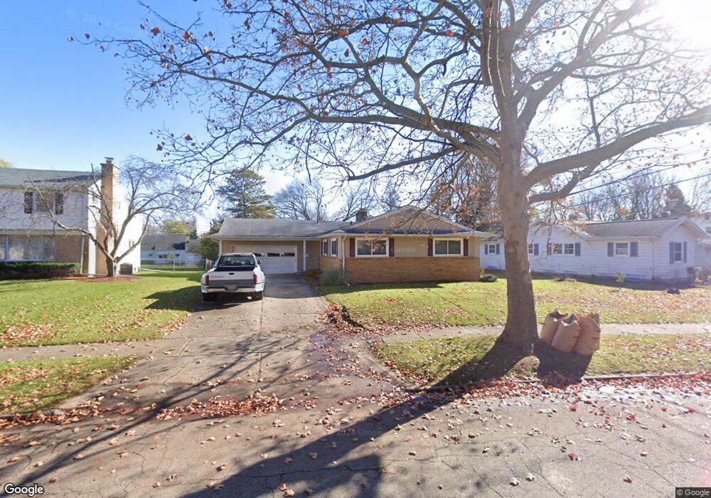
About This Home
This home is located at 2111 Hampden Dr, Lansing, MI 48911 and is currently estimated at $231,690, approximately $156 per square foot. 2111 Hampden Dr is a home located in Ingham County with nearby schools including Averill Elementary School, Attwood School, and J.W. Sexton High School.
Ownership History
We collect this data history from publicly available records. To have your information removed, we recommend requesting removal directly through your county’s website.
Purchase Details
Purchase Details
Purchase Details
Home Values in the Area
Average Home Value in this Area
Purchase History
We collect this data history from publicly available records. To have your information removed, we recommend requesting removal directly through your county’s website.
| Date | Buyer | Sale Price | Title Company |
|---|---|---|---|
| -- | -- | ||
| $81,500 | -- | ||
| $80,000 | -- |
Tax History
We collect this data history from publicly available records. To have your information removed, we recommend requesting removal directly through your county’s website.
| Year | Tax Paid | Tax Assessment Tax Assessment Total Assessment is a certain percentage of the fair market value that is determined by local assessors to be the total taxable value of land and additions on the property. | Land | Improvement |
|---|---|---|---|---|
| 2025 | $3,005 | $113,000 | $14,000 | $99,000 |
| 2024 | $29 | $101,300 | $14,000 | $87,300 |
| 2023 | $3,423 | $89,000 | $14,000 | $75,000 |
| 2022 | $3,084 | $78,100 | $12,100 | $66,000 |
| 2021 | $3,020 | $72,000 | $11,200 | $60,800 |
| 2020 | $3,002 | $68,000 | $11,200 | $56,800 |
| 2019 | $2,879 | $61,400 | $11,200 | $50,200 |
| 2018 | $2,696 | $55,600 | $11,200 | $44,400 |
| 2017 | $2,582 | $55,600 | $11,200 | $44,400 |
| 2016 | $2,469 | $48,700 | $11,200 | $37,500 |
| 2015 | $2,469 | $45,700 | $22,382 | $23,318 |
| 2014 | $2,469 | $44,100 | $22,382 | $21,718 |
Map
- 2222 Fairfax Rd
- 1915 Cooper Ave
- 2510 Chatham Rd
- 1910 Gordon Ave
- 2117 Edwin Place
- 2709 Belaire Dr
- 1810 Cooper Ave
- 2200 Rossiter Place
- 1717 Cooper Ave
- 1716 Gordon Ave
- 2409 Victor Ave
- 2801 Chatham Rd
- 1740 Wellington Rd Unit 207
- 1740 Wellington Rd Unit 103
- 1740 Wellington Rd Unit 110
- 1729 Loraine Ave
- 1727 Wellington Rd
- 2122 Quentin Ave
- 2525 Bedford Rd
- 2908 Westchester Rd
- 2118 Pleasant Grove Rd
- 2124 Pleasant Grove Rd
- 2114 Pleasant Grove Rd
- 2126 Pleasant Grove Rd
- 2106 Pleasant Grove Rd
- 2200 Pleasant Grove Rd
- 2211 Hampden Dr
- 2117 Hampden Dr
- 2127 Pleasant Grove Rd
- 2100 Pleasant Grove Rd
- 2219 Hampden Dr
- 2208 Pleasant Grove Rd
- 2101 Pleasant Grove Rd
- 2118 Cooper Ave
- 2101 Hampden Dr
- 2115 Cooper Ave
- 2018 Pleasant Grove Rd
- 2225 Hampden Dr
- 2218 Pleasant Grove Rd
- 2114 Cooper Ave
Ask me questions while you tour the home.