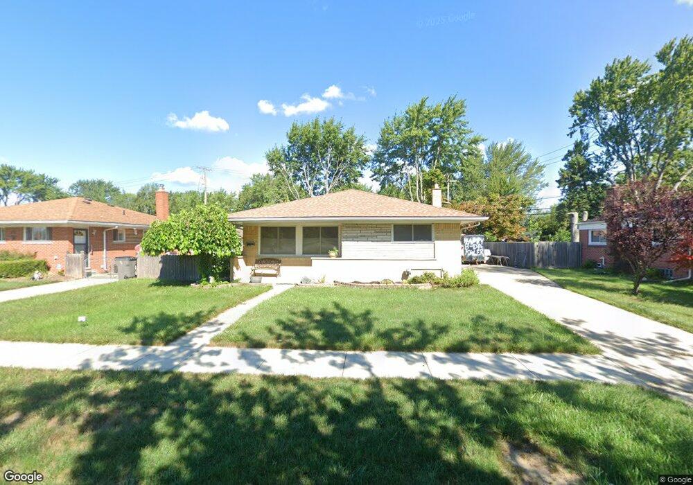
21115 Danbury St Clinton Township, MI 48035
Estimated Value: $230,000 - $244,000
3
Beds
2
Baths
1,057
Sq Ft
$224/Sq Ft
Est. Value
About This Home
This home is located at 21115 Danbury St, Clinton Township, MI 48035 and is currently estimated at $236,943, approximately $224 per square foot. 21115 Danbury St is a home located in Macomb County with nearby schools including Clintondale High School, St. Thecla Catholic School, and Faith Christian School.
Ownership History
Date
Name
Owned For
Owner Type
Purchase Details
Closed on
Aug 5, 2016
Sold by
Orrell Michael and Puumala Jessica
Bought by
Orrell David Brian
Current Estimated Value
Home Financials for this Owner
Home Financials are based on the most recent Mortgage that was taken out on this home.
Original Mortgage
$112,917
Outstanding Balance
$90,153
Interest Rate
3.5%
Mortgage Type
FHA
Estimated Equity
$146,790
Purchase Details
Closed on
May 15, 2006
Sold by
Goodchild Susan A
Bought by
Orrell Michael
Create a Home Valuation Report for This Property
The Home Valuation Report is an in-depth analysis detailing your home's value as well as a comparison with similar homes in the area
Home Values in the Area
Average Home Value in this Area
Purchase History
| Date | Buyer | Sale Price | Title Company |
|---|---|---|---|
| Orrell David Brian | $115,000 | Title Source Inc | |
| Orrell Michael | $155,300 | Title Source Inc |
Source: Public Records
Mortgage History
| Date | Status | Borrower | Loan Amount |
|---|---|---|---|
| Open | Orrell David Brian | $112,917 |
Source: Public Records
Tax History Compared to Growth
Tax History
| Year | Tax Paid | Tax Assessment Tax Assessment Total Assessment is a certain percentage of the fair market value that is determined by local assessors to be the total taxable value of land and additions on the property. | Land | Improvement |
|---|---|---|---|---|
| 2025 | $2,412 | $102,400 | $0 | $0 |
| 2024 | $1,490 | $91,600 | $0 | $0 |
| 2023 | $1,415 | $83,200 | $0 | $0 |
| 2022 | $2,181 | $74,200 | $0 | $0 |
| 2021 | $2,120 | $70,500 | $0 | $0 |
| 2020 | $1,475 | $67,100 | $0 | $0 |
| 2019 | $1,985 | $62,800 | $0 | $0 |
| 2018 | $1,955 | $57,300 | $0 | $0 |
| 2017 | $1,930 | $43,600 | $7,400 | $36,200 |
| 2016 | $2,418 | $43,600 | $0 | $0 |
| 2015 | -- | $38,400 | $0 | $0 |
| 2014 | -- | $36,400 | $0 | $0 |
| 2011 | -- | $43,900 | $12,100 | $31,800 |
Source: Public Records
Map
Nearby Homes
- 35906 Rewa St
- 35811 Weideman St
- 21640 Hillside #3c Dr
- 35903 Little MacK Ave
- 20830 Lantz St
- 36047 Weideman St
- 36335 Weideman St
- 35403 Seville St
- 21237 Woodward St
- 21600 Elmway St
- 21156 Woodward St
- 21132 Woodward St
- 36426 Weideman St
- 21228 Woodward St
- 20975 Catalano St
- 20550 Vermander Ave
- 36027 Vaughn St
- 20309 Abrahm St
- 20176 15 Mile Rd
- 21911 Sharkey St
- 21101 Danbury St
- 21129 Danbury St
- 21072 Suffolk St
- 21063 Danbury St
- 21140 Wakefield St
- 21060 Suffolk St
- 21143 Danbury St
- 21114 Danbury St
- 21120 Wakefield St
- 21051 Danbury St
- 21128 Danbury St
- 21048 Suffolk St
- 35543 Golden Dr
- 21140 Danbury St
- 21039 Danbury St
- 35532 Golden Dr
- 21152 Danbury St
- 35529 Golden Dr
- 21211 Wakefield St
- 21029 Danbury St