
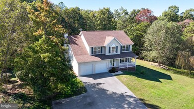


21117 Catnip Ct Leonardtown, MD 20650
Estimated payment $3,568/month
Highlights
- 1.38 Acre Lot
- Colonial Architecture
- 1 Fireplace
- Leonardtown Middle School Rated A-
- Partially Wooded Lot
- Combination Kitchen and Living
About This Home
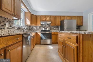
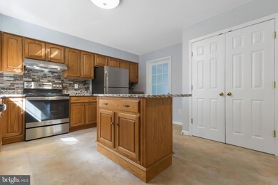
Located on a quiet, no-through street in the desirable Kingston Estates community of Leonardtown, this home sits atop a gentle hill with no other houses in sight, offering exceptional privacy. A classic southern-style front porch welcomes you with views of mature landscaping, including weeping willows. The extra-large driveway provides ample parking, including two additional spaces beyond the attached garage. Inside you’re greeted by a soaring two-story foyer that sets an elegant tone. The main level features a traditional layout with real hardwood flooring in the living room and new flooring throughout the remainder of the level. Fresh paint adds a clean, modern finish. At the front of the home, a room with French doors offers flexibility as a formal dining room, office, or study. The eat-in kitchen includes marble countertops, a center island, tile backsplash, stainless steel GE appliances, and a large walk-in pantry. The kitchen opens to a cozy family room with a wood-burning fireplace, perfect for gathering. A convenient half bath completes the main floor. The upper level includes four spacious bedrooms, all with new flooring and fresh paint, plus real hardwood flooring in the hallway. The primary suite enjoys wooded views from numerous windows, along with a soaking tub, dual sinks, a walk-in shower, and a generous linen closet. A second full bathroom serves the additional bedrooms.
The fully finished basement offers incredible versatility with a fifth bedroom, full bathroom, wet bar, laundry area, and flex space ideal for a gym, rec room, or office. It’s been freshly painted and is ready to adapt to your needs. Step outside to a composite screened deck and private backyard, which backs to a Forest Conservation Area ready for exploration. There’s also a small, fenced area perfect for pets. Despite the wooded surroundings, you’ll enjoy plenty of open, usable yard space. Two sheds offer additional utility, including a “Man Cave or She Shed” with heat & a/c as well as a 20′×24′ Amish-built structure with electric and lofts, perfect for storage or a workshop. With over 3,000 sq ft of finished living space, a thoughtful layout, and flexible rooms that adapt to a variety of needs, this lovingly maintained home—offered by its original owners—is designed to support your lifestyle through every season of life. Nestled on a peaceful 1.38-acre lot, it also provides peace of mind with major system and structural updates, including two high-efficiency HVAC systems (2023 & 2025), a durable architectural roof (2018), and a whole-home water filtration system for added comfort and water quality. Whether you're working from home, hosting guests, or embracing your next chapter, this property blends functionality, space, and long-term value
Listing Agent
(301) 904-6490 melissa@somdhomesales.net RE/MAX One License #5013745 Listed on: 10/17/2025

Open House Schedule
-
Sunday, November 23, 20251:00 to 3:00 pm11/23/2025 1:00:00 PM +00:0011/23/2025 3:00:00 PM +00:00Add to Calendar
Home Details
Home Type
- Single Family
Est. Annual Taxes
- $3,799
Year Built
- Built in 2003
Lot Details
- 1.38 Acre Lot
- Rural Setting
- Landscaped
- No Through Street
- Partially Wooded Lot
- Backs to Trees or Woods
- Back Yard
- Property is zoned RPD
HOA Fees
- $35 Monthly HOA Fees
Parking
- 2 Car Attached Garage
- Front Facing Garage
- Garage Door Opener
- Driveway
Home Design
- Colonial Architecture
- Slab Foundation
- Architectural Shingle Roof
- Vinyl Siding
Interior Spaces
- Property has 3 Levels
- Ceiling Fan
- 1 Fireplace
- Screen For Fireplace
- Combination Kitchen and Living
- Dining Area
- Luxury Vinyl Plank Tile Flooring
- Finished Basement
- Laundry in Basement
- Storm Doors
- Washer and Dryer Hookup
Kitchen
- Eat-In Kitchen
- Walk-In Pantry
- Stove
- Dishwasher
- Stainless Steel Appliances
- Kitchen Island
Bedrooms and Bathrooms
- En-Suite Bathroom
- Walk-In Closet
- Soaking Tub
Accessible Home Design
- More Than Two Accessible Exits
Outdoor Features
- Patio
- Shed
- Porch
Schools
- Leonardtown Elementary And Middle School
- Leonardtown High School
Utilities
- Central Air
- Heat Pump System
- Vented Exhaust Fan
- Electric Water Heater
- On Site Septic
- Satellite Dish
Listing and Financial Details
- Tax Lot 51
- Assessor Parcel Number 1903067025
Map
Home Values in the Area
Average Home Value in this Area
Tax History
| Year | Tax Paid | Tax Assessment Tax Assessment Total Assessment is a certain percentage of the fair market value that is determined by local assessors to be the total taxable value of land and additions on the property. | Land | Improvement |
|---|---|---|---|---|
| 2025 | $4,282 | $416,400 | $131,900 | $284,500 |
| 2024 | $4,070 | $395,800 | $0 | $0 |
| 2023 | $3,825 | $375,200 | $0 | $0 |
| 2022 | $3,704 | $354,600 | $131,900 | $222,700 |
| 2021 | $3,644 | $348,867 | $0 | $0 |
| 2020 | $3,584 | $343,133 | $0 | $0 |
| 2019 | $3,524 | $337,400 | $131,900 | $205,500 |
| 2018 | $3,517 | $336,900 | $0 | $0 |
| 2017 | $3,493 | $336,400 | $0 | $0 |
| 2016 | -- | $335,900 | $0 | $0 |
| 2015 | $3,241 | $335,900 | $0 | $0 |
| 2014 | $3,241 | $335,900 | $0 | $0 |
Property History
| Date | Event | Price | List to Sale | Price per Sq Ft |
|---|---|---|---|---|
| 11/07/2025 11/07/25 | Price Changed | $610,000 | -6.1% | $173 / Sq Ft |
| 10/17/2025 10/17/25 | For Sale | $649,900 | -- | $184 / Sq Ft |
Purchase History
| Date | Type | Sale Price | Title Company |
|---|---|---|---|
| Deed | $265,541 | -- | |
| Deed | $168,634 | -- |
Mortgage History
| Date | Status | Loan Amount | Loan Type |
|---|---|---|---|
| Closed | -- | No Value Available |
Source: Bright MLS
MLS Number: MDSM2027750
APN: 03-067025
Disclaimer: Certain information contained herein is derived from information provided by parties other than Homes.com. All information provided is deemed reliable, but is not guaranteed to be accurate and should be independently verified.
![]() The data relating to real estate for sale on this website appears in part through the BRIGHT Internet Data Exchange program, a voluntary cooperative exchange of property listing data between licensed real estate brokerage firms, and is provided by BRIGHT through a licensing agreement.
The data relating to real estate for sale on this website appears in part through the BRIGHT Internet Data Exchange program, a voluntary cooperative exchange of property listing data between licensed real estate brokerage firms, and is provided by BRIGHT through a licensing agreement.
Listing information is from various brokers who participate in the Bright MLS IDX program and not all listings may be visible on the site.
The property information being provided on or through the website is for the personal, non-commercial use of consumers and such information may not be used for any purpose other than to identify prospective properties consumers may be interested in purchasing.
Some properties which appear for sale on the website may no longer be available because they are for instance, under contract, sold or are no longer being offered for sale.
Property information displayed is deemed reliable but is not guaranteed.
Copyright 2025 Bright MLS, Inc.
- 42043 Starlight Dr
- 21039 Woodmere Dr
- 42611 Wilderness Rd
- 21515 Our Drive Way
- 20959 Redgate Ln
- 43107 Gum Spring Dr
- 42520 Riverwinds Dr
- 22216 Hanover Dr
- 20753 Chestnut Ridge Dr
- 40412 B Somerville Ln
- 41832 Foxwell Point Ln
- 43488 Medleys Neck Rd
- 22539 Landing Way
- 21983 Point Lookout Rd
- 0 Cedar Lane Rd
- 19921 Tower Hill Rd
- 19700 Mulberry Fields Rd
- 22362 Armstrong Dr
- 25365 Point Lookout Rd
- 21745 Pinehurst Ct
- 42271 Bird Haven Dr
- 20670 Bloombury Ln
- 21692 Potomac View Dr
- 42151 Blacksmith Shop Rd
- 40905 Spring House Ln
- 44980 Hamptons Blvd
- 22397 Armstrong Dr
- 23398 Hollywood Rd
- 23067 Town Run Dr
- 44131 Beaver Creek Dr
- 44179 Beaver Creek Dr
- 44075 Louisdale Rd
- 23171 Ambrosia Ln
- 23177 Ambrosia Ln
- 43718 Winterberry Way
- 43625 Marguerite St
- 43840 Tarrywyle Way
- 23293 Misty Pond Ln
- 20954 Pintail Ct
- 23052 Wetstone Ln Unit C