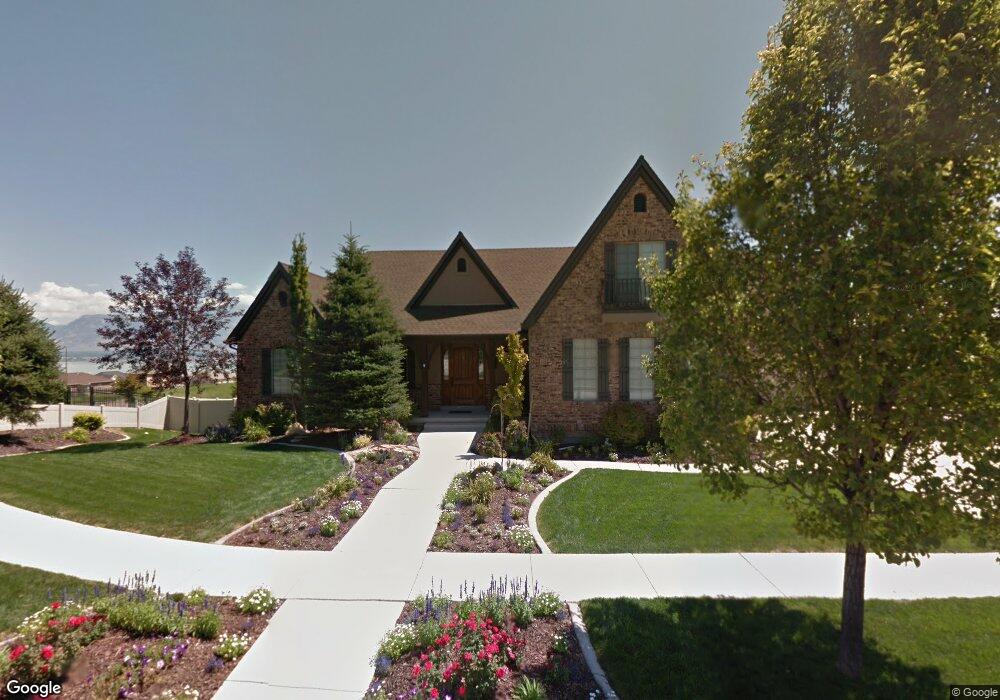
2112 S Weatherby Dr Saratoga Springs, UT 84045
Estimated Value: $646,000 - $867,000
5
Beds
4
Baths
5,101
Sq Ft
$158/Sq Ft
Est. Value
About This Home
This home is located at 2112 S Weatherby Dr, Saratoga Springs, UT 84045 and is currently estimated at $804,273, approximately $157 per square foot. 2112 S Weatherby Dr is a home located in Utah County with nearby schools including Sage Hills Elementary School, Lake Mountain Middle School, and Westlake High School.
Ownership History
Date
Name
Owned For
Owner Type
Purchase Details
Closed on
Dec 8, 2014
Sold by
Tanner Blaine
Bought by
Rebecca Ann Tanner Family Protection Tru and Tanner Blaine Lowell
Current Estimated Value
Home Financials for this Owner
Home Financials are based on the most recent Mortgage that was taken out on this home.
Original Mortgage
$364,000
Outstanding Balance
$280,473
Interest Rate
4.16%
Mortgage Type
New Conventional
Estimated Equity
$523,800
Purchase Details
Closed on
Nov 7, 2014
Sold by
Melaleuca Inc
Bought by
Tanner Blaine
Home Financials for this Owner
Home Financials are based on the most recent Mortgage that was taken out on this home.
Original Mortgage
$364,000
Outstanding Balance
$280,473
Interest Rate
4.16%
Mortgage Type
New Conventional
Estimated Equity
$523,800
Purchase Details
Closed on
Sep 24, 2014
Sold by
Rencher George A
Bought by
Melaleuca Inc
Home Financials for this Owner
Home Financials are based on the most recent Mortgage that was taken out on this home.
Original Mortgage
$364,000
Outstanding Balance
$280,473
Interest Rate
4.16%
Mortgage Type
New Conventional
Estimated Equity
$523,800
Purchase Details
Closed on
Sep 20, 2010
Sold by
King Rex E
Bought by
Rencher George A
Home Financials for this Owner
Home Financials are based on the most recent Mortgage that was taken out on this home.
Original Mortgage
$312,000
Interest Rate
4.35%
Mortgage Type
New Conventional
Purchase Details
Closed on
Aug 18, 2010
Sold by
Archer Robert Michael and Archer Shannon
Bought by
King Rex E
Home Financials for this Owner
Home Financials are based on the most recent Mortgage that was taken out on this home.
Original Mortgage
$312,000
Interest Rate
4.35%
Mortgage Type
New Conventional
Purchase Details
Closed on
Feb 19, 2008
Sold by
Knight West Construction Inc
Bought by
Archer Robert Michael and Archer Shannon
Home Financials for this Owner
Home Financials are based on the most recent Mortgage that was taken out on this home.
Original Mortgage
$72,700
Interest Rate
5.41%
Mortgage Type
Stand Alone Second
Purchase Details
Closed on
Apr 24, 2007
Sold by
Land Rock Development Lc
Bought by
Knight West Construction Inc
Home Financials for this Owner
Home Financials are based on the most recent Mortgage that was taken out on this home.
Original Mortgage
$365,000
Interest Rate
6.11%
Mortgage Type
Construction
Create a Home Valuation Report for This Property
The Home Valuation Report is an in-depth analysis detailing your home's value as well as a comparison with similar homes in the area
Home Values in the Area
Average Home Value in this Area
Purchase History
| Date | Buyer | Sale Price | Title Company |
|---|---|---|---|
| Rebecca Ann Tanner Family Protection Tru | -- | Title West | |
| Tanner Blaine | -- | Title One | |
| Melaleuca Inc | -- | First American Title Co Llc | |
| Rencher George A | -- | Investors Title Insurance A | |
| King Rex E | -- | Investors Title Insurance A | |
| Archer Robert Michael | -- | Signature Title Insurance A | |
| Knight West Construction Inc | -- | Signature Title Insurance A |
Source: Public Records
Mortgage History
| Date | Status | Borrower | Loan Amount |
|---|---|---|---|
| Open | Tanner Blaine | $364,000 | |
| Previous Owner | Rencher George A | $312,000 | |
| Previous Owner | King Rex E | $215,000 | |
| Previous Owner | Archer Robert Michael | $72,700 | |
| Previous Owner | Knight West Construction Inc | $365,000 |
Source: Public Records
Tax History Compared to Growth
Tax History
| Year | Tax Paid | Tax Assessment Tax Assessment Total Assessment is a certain percentage of the fair market value that is determined by local assessors to be the total taxable value of land and additions on the property. | Land | Improvement |
|---|---|---|---|---|
| 2025 | $3,291 | $801,900 | $256,600 | $545,300 |
| 2024 | $3,291 | $395,340 | $0 | $0 |
| 2023 | $2,987 | $385,880 | $0 | $0 |
| 2022 | $3,405 | $428,835 | $0 | $0 |
| 2021 | $2,941 | $552,900 | $144,800 | $408,100 |
| 2020 | $2,826 | $521,700 | $129,300 | $392,400 |
| 2019 | $2,650 | $506,800 | $125,400 | $381,400 |
| 2018 | $2,522 | $455,100 | $117,500 | $337,600 |
| 2017 | $2,387 | $230,450 | $0 | $0 |
| 2016 | $2,500 | $223,960 | $0 | $0 |
| 2015 | $2,633 | $223,795 | $0 | $0 |
| 2014 | $2,420 | $203,335 | $0 | $0 |
Source: Public Records
Map
Nearby Homes
- 2162 S Ruger Dr
- 2238 S Western Dr
- 2039 S Roan Ave
- 2274 S Browning Dr
- 2199 S Morgan Rd
- 2226 S Maverick Rd
- 2262 S Maverick Rd
- 53 Lake View Terrace Rd
- 153 W Honeysuckle Dr
- 2559 S Colt Dr
- 127 W Honeysuckle Dr Unit 221
- 244 E Range Rd
- 2387 S Maverick Rd W
- 151 E Cameron Dr
- 7323 N Long Dr Unit 607
- 2478 S Lilac Ln
- 231 S Wiltshire Ln
- 197 W Parkside Dr
- 272 E Bennett Ln Unit 117
- 262 E Bennett Ln Unit 118
- 2112 S Weatherby Dr
- 2136 S Weatherby Dr Unit 807
- 2136 S Weatherby Dr
- 2092 S Weatherby Dr
- 2092 S Weatherby Dr
- 364 W Apaloosa Dr
- 2113 Weatherby Dr
- 2097 S Weatherby Dr
- 2097 S Weatherby Dr
- 2087 S Weatherby Dr Unit 810
- 2087 S Weatherby Dr Unit 810
- 2146 S Weatherby Dr
- 2141 S Weatherby Dr Unit 841
- 2112 S Ruger Dr
- 2096 S Ruger Dr
- 2096 S Ruger Dr
- 2151 S Weatherby Dr
- 2151 S Weatherby Dr Unit 842
- 2142 S Ruger Dr Unit 840
- 352 W Weatherby Dr