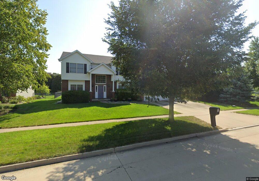
2112 Strand Dr Champaign, IL 61822
Estimated Value: $439,887 - $539,000
--
Bed
--
Bath
--
Sq Ft
0.25
Acres
About This Home
This home is located at 2112 Strand Dr, Champaign, IL 61822 and is currently estimated at $485,222. 2112 Strand Dr is a home located in Champaign County with nearby schools including Centennial High School, Countryside School, and Swann Special Care Center-Elem/Secondary School.
Ownership History
Date
Name
Owned For
Owner Type
Purchase Details
Closed on
May 7, 2003
Sold by
Quiram Jay and Quiram Jody
Bought by
Marquart Frank K and Burke Marquart Melissa
Current Estimated Value
Home Financials for this Owner
Home Financials are based on the most recent Mortgage that was taken out on this home.
Original Mortgage
$85,000
Interest Rate
5.29%
Mortgage Type
Purchase Money Mortgage
Create a Home Valuation Report for This Property
The Home Valuation Report is an in-depth analysis detailing your home's value as well as a comparison with similar homes in the area
Home Values in the Area
Average Home Value in this Area
Purchase History
| Date | Buyer | Sale Price | Title Company |
|---|---|---|---|
| Marquart Frank K | $270,000 | -- |
Source: Public Records
Mortgage History
| Date | Status | Borrower | Loan Amount |
|---|---|---|---|
| Closed | Marquart Frank K | $85,000 |
Source: Public Records
Tax History Compared to Growth
Tax History
| Year | Tax Paid | Tax Assessment Tax Assessment Total Assessment is a certain percentage of the fair market value that is determined by local assessors to be the total taxable value of land and additions on the property. | Land | Improvement |
|---|---|---|---|---|
| 2024 | $10,018 | $125,410 | $23,820 | $101,590 |
| 2023 | $10,018 | $115,790 | $21,990 | $93,800 |
| 2022 | $9,512 | $108,010 | $20,510 | $87,500 |
| 2021 | $9,284 | $106,100 | $20,150 | $85,950 |
| 2020 | $9,197 | $105,050 | $19,950 | $85,100 |
| 2019 | $8,921 | $103,300 | $19,620 | $83,680 |
| 2018 | $8,907 | $103,300 | $19,620 | $83,680 |
| 2017 | $8,917 | $103,300 | $19,620 | $83,680 |
| 2016 | $8,072 | $102,100 | $19,620 | $82,480 |
| 2015 | $8,168 | $102,100 | $19,620 | $82,480 |
| 2014 | $7,803 | $97,340 | $19,620 | $77,720 |
| 2013 | $7,734 | $97,340 | $19,620 | $77,720 |
Source: Public Records
Map
Nearby Homes
- 2004 Emerald Dr
- 4502 Graves Ct
- 4712 Watermark Dr
- 1904 Mullikin Dr
- 4410 Southford Trace Dr
- 2104 Wiggins St
- 4406 Crossgate Dr
- 4309 Stonebridge Ct
- 2009 Savanna Dr
- 2317 Joseph St
- 2107 Max Run Dr
- 4700 Chestnut Grove Dr
- 5008 Emmas Way
- 4111 Farhills Dr
- 4809 W Windsor Rd Unit C02
- 4809 W Windsor Rd Unit C12
- 4809 W Windsor Rd Unit D05
- 4809 W Windsor Rd Unit A15
- 4809 W Windsor Rd Unit F28
- 4809 W Windsor Rd Unit C23
- 2110 Strand Dr
- 2114 Strand Dr
- 2113 Mullikin Dr
- 2111 Mullikin Dr
- 2108 Strand Dr
- 2115 Mullikin Dr
- 2109 Mullikin Dr
- 2113 Strand Dr
- 2111 Strand Dr
- 2115 Strand Dr
- 2109 Strand Dr
- 2106 Strand Dr
- 2202 Strand Dr
- 2107 Mullikin Dr
- 2107 Strand Dr
- 4605 Stonebridge Dr
- 2105 Mullikin Dr
- 2104 Strand Dr
- 4601 Stonebridge Dr
- 2201 Strand Dr