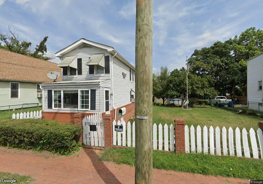
2113 Hollins Ferry Rd Baltimore, MD 21230
Estimated Value: $171,000 - $230,416
--
Bed
1
Bath
1,430
Sq Ft
$140/Sq Ft
Est. Value
About This Home
This home is located at 2113 Hollins Ferry Rd, Baltimore, MD 21230 and is currently estimated at $200,708, approximately $140 per square foot. 2113 Hollins Ferry Rd is a home located in Baltimore City with nearby schools including Morrell Park Elementary/Middle School, Booker T. Washington Middle School, and Edmondson Westside High School.
Ownership History
Date
Name
Owned For
Owner Type
Purchase Details
Closed on
Mar 29, 1994
Sold by
Bealefeld Est E E
Bought by
Gant Victor A
Current Estimated Value
Home Financials for this Owner
Home Financials are based on the most recent Mortgage that was taken out on this home.
Original Mortgage
$55,000
Interest Rate
7.15%
Create a Home Valuation Report for This Property
The Home Valuation Report is an in-depth analysis detailing your home's value as well as a comparison with similar homes in the area
Home Values in the Area
Average Home Value in this Area
Purchase History
| Date | Buyer | Sale Price | Title Company |
|---|---|---|---|
| Gant Victor A | $55,000 | -- |
Source: Public Records
Mortgage History
| Date | Status | Borrower | Loan Amount |
|---|---|---|---|
| Closed | Gant Victor A | $55,000 |
Source: Public Records
Tax History Compared to Growth
Tax History
| Year | Tax Paid | Tax Assessment Tax Assessment Total Assessment is a certain percentage of the fair market value that is determined by local assessors to be the total taxable value of land and additions on the property. | Land | Improvement |
|---|---|---|---|---|
| 2025 | $1,716 | $110,033 | -- | -- |
| 2024 | $1,716 | $95,067 | $0 | $0 |
| 2023 | $1,890 | $80,100 | $16,000 | $64,100 |
| 2022 | $1,890 | $80,100 | $16,000 | $64,100 |
| 2021 | $1,890 | $80,100 | $16,000 | $64,100 |
| 2020 | $86 | $80,100 | $16,000 | $64,100 |
| 2019 | $58 | $80,100 | $16,000 | $64,100 |
| 2018 | $1,600 | $80,100 | $16,000 | $64,100 |
| 2017 | $48 | $105,400 | $0 | $0 |
| 2016 | -- | $105,400 | $0 | $0 |
| 2015 | $194 | $105,400 | $0 | $0 |
| 2014 | $194 | $118,400 | $0 | $0 |
Source: Public Records
Map
Nearby Homes
- 2012 Griffis Ave
- 0 Harman Ave
- 2410 Huron St
- 1933 Griffis Ave
- 2006 Grinnalds Ave
- 1915 Griffis Ave
- 1919 Grinnalds Ave
- 2404 Puget St
- 2104 Whistler Ave
- 2507 Washington Blvd
- 1715 Spence St
- 2506 Washington Blvd
- 1703 - 1707 1/2 Spence St
- 2305 Herkimer St
- 1701 Spence St
- 2630 Alaska St
- 1962 Sponson St
- 2625 Waterview Ave
- 1918 Parksley Ave
- 2613 Maisel St
- 2119 Hollins Ferry Rd
- 2121 Hollins Ferry Rd
- 2125 Hollins Ferry Rd
- 2123 Hollins Ferry Rd
- 2109 Hollins Ferry Rd
- 2107 Hollins Ferry Rd
- 2120 Maisel St
- 2105 Hollins Ferry Rd
- 2127 Hollins Ferry Rd
- 2124 Maisel St
- 2106 Maisel St
- 2126 Maisel St
- 2130 Maisel St
- 2102 Maisel St
- 2132 Maisel St
- 2100 Hollins Ferry Rd
- 2231 Wicomico St
- 2125 Maisel St
- 2223 Wicomico St
- 2127 Maisel St