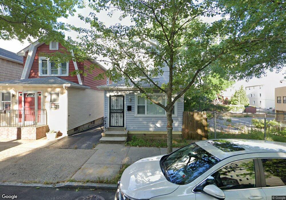
2117 St Paul Ave Bronx, NY 10461
Middletown-Pelham Bay NeighborhoodEstimated Value: $691,000 - $752,000
--
Bed
2
Baths
1,280
Sq Ft
$558/Sq Ft
Est. Value
About This Home
This home is located at 2117 St Paul Ave, Bronx, NY 10461 and is currently estimated at $713,690, approximately $557 per square foot. 2117 St Paul Ave is a home located in Bronx County with nearby schools including P.S. 71 Rose E Scala, Herbert H Lehman High School, and Icahn Charter School 3.
Ownership History
Date
Name
Owned For
Owner Type
Purchase Details
Closed on
Mar 7, 2012
Sold by
Nieves Maria and Rivera Adeleen
Bought by
Nieves Maria
Current Estimated Value
Purchase Details
Closed on
Apr 18, 2005
Sold by
Nieves Maria
Bought by
Nieves Maria and Rivera Adeleen
Home Financials for this Owner
Home Financials are based on the most recent Mortgage that was taken out on this home.
Original Mortgage
$184,000
Interest Rate
6.05%
Mortgage Type
Purchase Money Mortgage
Create a Home Valuation Report for This Property
The Home Valuation Report is an in-depth analysis detailing your home's value as well as a comparison with similar homes in the area
Home Values in the Area
Average Home Value in this Area
Purchase History
| Date | Buyer | Sale Price | Title Company |
|---|---|---|---|
| Nieves Maria | -- | -- | |
| Nieves Maria | -- | -- | |
| Nieves Maria | -- | -- | |
| Nieves Maria | -- | -- |
Source: Public Records
Mortgage History
| Date | Status | Borrower | Loan Amount |
|---|---|---|---|
| Previous Owner | Nieves Maria | $184,000 |
Source: Public Records
Tax History Compared to Growth
Tax History
| Year | Tax Paid | Tax Assessment Tax Assessment Total Assessment is a certain percentage of the fair market value that is determined by local assessors to be the total taxable value of land and additions on the property. | Land | Improvement |
|---|---|---|---|---|
| 2025 | $2,011 | $29,285 | $6,072 | $23,213 |
| 2024 | $2,011 | $27,628 | $6,829 | $20,799 |
| 2023 | $4,634 | $26,064 | $7,357 | $18,707 |
| 2022 | $1,803 | $35,520 | $10,500 | $25,020 |
| 2021 | $2,011 | $34,500 | $10,500 | $24,000 |
| 2020 | $1,924 | $34,020 | $10,500 | $23,520 |
| 2019 | $1,749 | $30,480 | $10,500 | $19,980 |
| 2018 | $1,555 | $21,720 | $10,500 | $11,220 |
| 2017 | $1,873 | $24,715 | $10,447 | $14,268 |
| 2016 | $1,849 | $24,715 | $9,402 | $15,313 |
| 2015 | $1,186 | $24,060 | $11,700 | $12,360 |
| 2014 | $1,186 | $23,140 | $11,309 | $11,831 |
Source: Public Records
Map
Nearby Homes
- 1874 Pelham Pkwy S Unit 6M
- 1874 Pelham Pkwy S Unit 5B
- 1874 Pelham Pkwy S Unit 6E
- 1874 Pelham Pkwy S Unit 4R
- 1910 Pelham Pkwy S Unit 5C
- 2032 Hobart Ave
- 2024 Continental Ave
- 2015 Saint Paul Ave Unit 3H
- 2015 St Paul Ave Unit 3G
- 2015 Saint Paul Ave Unit 6B
- 2887 E 194th St
- 2871 E 194th St
- 2010 Hobart Ave
- 1950 Pilgrim Ave
- 2211 de Reimer Ave
- 2201 Palmer Ave
- 1926 Hutchinson River Pkwy E Unit E
- 2884 Saint Theresa Ave
- 2225 Boller Ave
- 2227 Boller Ave
- 2117 Saint Paul Ave
- 2115 Saint Paul Ave
- 2119 Saint Paul Ave
- 2113 Saint Paul Ave
- 2111 Saint Paul Ave
- 2109 Saint Paul Ave
- 2107 St Paul Ave
- 2107 Saint Paul Ave
- 2112 Saint Paul Ave
- 2120 Saint Paul Ave
- 2122 Continental Ave
- 2116 Continental Ave
- 2124 Saint Paul Ave
- 2110 Saint Paul Ave
- 2126 Continental Ave
- 2105 Saint Paul Ave
- 2108 Saint Paul Ave
- 2112 Continental Ave Unit 2L
- 2112 Continental Ave Unit 2R
- 2112 Continental Ave Unit 2F