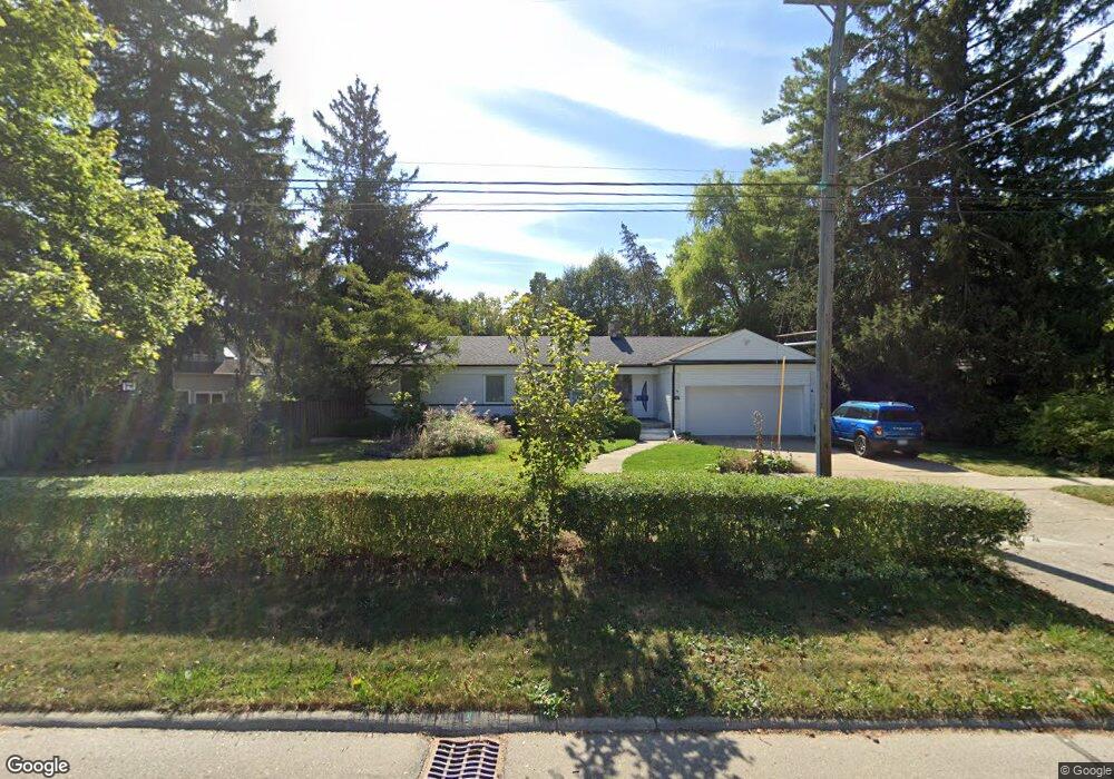
2117 W Maple Rd Birmingham, MI 48009
Estimated Value: $470,000 - $648,000
3
Beds
2
Baths
1,590
Sq Ft
$353/Sq Ft
Est. Value
About This Home
This home is located at 2117 W Maple Rd, Birmingham, MI 48009 and is currently estimated at $561,793, approximately $353 per square foot. 2117 W Maple Rd is a home located in Oakland County with nearby schools including Pierce Elementary School, Derby Middle School, and Ernest W. Seaholm High School.
Ownership History
Date
Name
Owned For
Owner Type
Purchase Details
Closed on
Dec 4, 2025
Sold by
Traeger Karin
Bought by
Lawrence Donald Mcalpine
Current Estimated Value
Purchase Details
Closed on
Apr 2, 2001
Sold by
Patria Angie
Bought by
Mcalpine Donald L
Home Financials for this Owner
Home Financials are based on the most recent Mortgage that was taken out on this home.
Original Mortgage
$124,000
Interest Rate
7.05%
Create a Home Valuation Report for This Property
The Home Valuation Report is an in-depth analysis detailing your home's value as well as a comparison with similar homes in the area
Home Values in the Area
Average Home Value in this Area
Purchase History
| Date | Buyer | Sale Price | Title Company |
|---|---|---|---|
| Lawrence Donald Mcalpine | -- | None Listed On Document | |
| Mcalpine Donald L | $214,000 | -- |
Source: Public Records
Mortgage History
| Date | Status | Borrower | Loan Amount |
|---|---|---|---|
| Previous Owner | Mcalpine Donald L | $124,000 |
Source: Public Records
Tax History
| Year | Tax Paid | Tax Assessment Tax Assessment Total Assessment is a certain percentage of the fair market value that is determined by local assessors to be the total taxable value of land and additions on the property. | Land | Improvement |
|---|---|---|---|---|
| 2025 | $5,631 | $202,460 | $0 | $0 |
| 2024 | $4,971 | $181,300 | $0 | $0 |
| 2023 | $4,764 | $177,600 | $0 | $0 |
| 2022 | $5,108 | $162,210 | $0 | $0 |
| 2021 | $5,153 | $160,420 | $0 | $0 |
| 2020 | $4,592 | $150,700 | $0 | $0 |
| 2019 | $5,196 | $149,400 | $0 | $0 |
| 2018 | $5,157 | $146,720 | $0 | $0 |
| 2017 | $5,148 | $145,510 | $0 | $0 |
| 2016 | $5,158 | $144,570 | $0 | $0 |
| 2015 | -- | $137,860 | $0 | $0 |
| 2014 | -- | $115,430 | $0 | $0 |
| 2011 | -- | $138,220 | $0 | $0 |
Source: Public Records
Map
Nearby Homes
- 169 N Glenhurst Dr
- 345 Kimberly St
- 394 S Glenhurst Dr
- 488 Bryn Mawr St
- 520 Pleasant St
- 757 Woodlea Ct
- 180 Pilgrim Ave
- 956 Westwood Dr
- 186 Hamilton Rd
- 999 Pleasant Ave
- 1120 Lyonhurst St
- 1171 Arden Ln
- 786 S Cranbrook Rd
- 2802 Heathfield Rd
- 2820 Heathfield Rd
- 1094 Suffield Ave
- 1057 Arlington St
- 2330 Fairway Dr
- 633 Hawthorne St
- 100 Overhill Rd
- 130 Argyle St Unit Bldg-Unit
- 130 Argyle St
- 2120 Avon Ln
- 2145 W Maple Rd
- 2130 Avon Ln
- 2154 Avon Ln
- 125 S Glenhurst Dr
- 145 S Glenhurst Dr
- 2180 Avon Ln
- 2195 W Maple Rd Unit Bldg-Unit
- 2195 W Maple Rd
- 161 S Glenhurst Dr
- 212 Argyle St Unit Bldg-Unit
- 212 Argyle St
- 2140 W Maple Rd
- 2200 Avon Ln
- 187 S Glenhurst Dr
- 130 Waddington St
- 2061 Avon Ln
- 215 Berwyn St
Your Personal Tour Guide
Ask me questions while you tour the home.