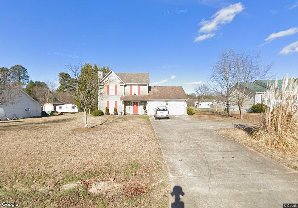
2118 Broad St Unit 1 Statham, GA 30666
Estimated Value: $280,000 - $297,000
3
Beds
3
Baths
1,450
Sq Ft
$198/Sq Ft
Est. Value
About This Home
This home is located at 2118 Broad St Unit 1, Statham, GA 30666 and is currently estimated at $287,233, approximately $198 per square foot. 2118 Broad St Unit 1 is a home located in Barrow County with nearby schools including Statham Elementary School, Bear Creek Middle School, and Winder-Barrow High School.
Ownership History
Date
Name
Owned For
Owner Type
Purchase Details
Closed on
Sep 26, 1997
Sold by
Wts Bldrs
Bought by
Rogers Kevin D and Rogers Mellisa L
Current Estimated Value
Home Financials for this Owner
Home Financials are based on the most recent Mortgage that was taken out on this home.
Original Mortgage
$89,500
Outstanding Balance
$14,518
Interest Rate
7.56%
Mortgage Type
New Conventional
Estimated Equity
$272,715
Create a Home Valuation Report for This Property
The Home Valuation Report is an in-depth analysis detailing your home's value as well as a comparison with similar homes in the area
Home Values in the Area
Average Home Value in this Area
Purchase History
| Date | Buyer | Sale Price | Title Company |
|---|---|---|---|
| Rogers Kevin D | $88,900 | -- |
Source: Public Records
Mortgage History
| Date | Status | Borrower | Loan Amount |
|---|---|---|---|
| Open | Rogers Kevin D | $89,500 |
Source: Public Records
Tax History Compared to Growth
Tax History
| Year | Tax Paid | Tax Assessment Tax Assessment Total Assessment is a certain percentage of the fair market value that is determined by local assessors to be the total taxable value of land and additions on the property. | Land | Improvement |
|---|---|---|---|---|
| 2024 | $1,566 | $55,912 | $12,000 | $43,912 |
| 2023 | $906 | $55,912 | $12,000 | $43,912 |
| 2022 | $1,342 | $48,986 | $12,000 | $36,986 |
| 2021 | $1,431 | $48,986 | $12,000 | $36,986 |
| 2020 | $1,436 | $48,986 | $12,000 | $36,986 |
| 2019 | $1,457 | $48,986 | $12,000 | $36,986 |
| 2018 | $1,253 | $42,888 | $12,000 | $30,888 |
| 2017 | $1,334 | $38,223 | $12,000 | $26,223 |
| 2016 | $1,093 | $38,542 | $12,000 | $26,542 |
| 2015 | $1,105 | $38,860 | $12,000 | $26,860 |
| 2014 | $882 | $33,378 | $5,880 | $27,498 |
| 2013 | -- | $32,074 | $5,880 | $26,194 |
Source: Public Records
Map
Nearby Homes
- 67 Defilippe Dr
- 97 Defilippe Dr
- 129 Purackal Ln
- 619 Graham Campbell Ln
- 341 Graham Campbell Ln
- 564 Peters St
- 2054 Jana Ln
- 1880 Oakley Trail
- 2641 Oakley Trail
- 2661 Oakley Trail
- 2540 Oakley Trail
- 2671 Oakley Trail
- 2665 Oakley Trail
- 139 Goldshore Way
- 227 Dove Field Dr Unit 84
- 247 Dove Field Dr Unit 83
- 267 Dove Field Dr Unit 82
- 287 Dove Field Dr
- 287 Dove Field Dr Unit 81
- 305 Dove Field Dr Unit 80
- 2124 Broad St
- 2114 Broad St
- 2110 Broad St Unit 1
- 2128 Broad St Unit 1
- 2132 Broad St
- 2106 Broad St Unit 1
- 2014 Rachael Dr
- 2018 Rachael Dr
- 2018 Rachael Dr Unit 2
- 2016 Rachael Dr Unit 2
- 2010 Rachael Dr
- 2010 Rachael Dr Unit 2
- 2136 Broad St Unit 1
- 2361 Daurian Dr
- 1668 Fairfield Springs Ln Unit 34
- 679 2205 Oldfield Dr
- 0 Arnold Rd Unit 8273329
- 0 Arnold Rd Unit 7274563
- 0 Arnold Rd Unit 7201224
- 0 Arnold Rd Unit 7201215