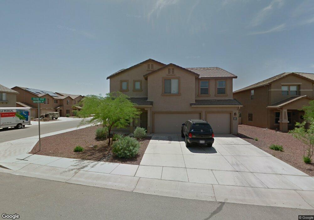
21189 E Independence Way Red Rock, AZ 85145
Estimated Value: $334,567 - $360,000
Studio
--
Bath
3,184
Sq Ft
$111/Sq Ft
Est. Value
About This Home
This home is located at 21189 E Independence Way, Red Rock, AZ 85145 and is currently estimated at $351,892, approximately $110 per square foot. 21189 E Independence Way is a home located in Pinal County with nearby schools including Red Rock Elementary School and Santa Cruz Valley Union High School.
Ownership History
Date
Name
Owned For
Owner Type
Purchase Details
Closed on
Oct 30, 2008
Sold by
Pulte Home Corporation
Bought by
Hines Richard Joseph and Hines Angelia J
Current Estimated Value
Home Financials for this Owner
Home Financials are based on the most recent Mortgage that was taken out on this home.
Original Mortgage
$238,137
Outstanding Balance
$156,396
Interest Rate
6.09%
Mortgage Type
VA
Estimated Equity
$195,496
Create a Home Valuation Report for This Property
The Home Valuation Report is an in-depth analysis detailing your home's value as well as a comparison with similar homes in the area
Home Values in the Area
Average Home Value in this Area
Purchase History
| Date | Buyer | Sale Price | Title Company |
|---|---|---|---|
| Hines Richard Joseph | $233,125 | Sun Title Agency Co |
Source: Public Records
Mortgage History
| Date | Status | Borrower | Loan Amount |
|---|---|---|---|
| Open | Hines Richard Joseph | $238,137 |
Source: Public Records
Tax History
| Year | Tax Paid | Tax Assessment Tax Assessment Total Assessment is a certain percentage of the fair market value that is determined by local assessors to be the total taxable value of land and additions on the property. | Land | Improvement |
|---|---|---|---|---|
| 2025 | $2,330 | $31,011 | -- | -- |
| 2024 | $2,195 | $29,260 | -- | -- |
| 2023 | $2,262 | $24,874 | $1,000 | $23,874 |
| 2022 | $2,195 | $19,435 | $1,000 | $18,435 |
| 2021 | $2,267 | $18,298 | $0 | $0 |
| 2020 | $2,186 | $17,776 | $0 | $0 |
| 2019 | $2,107 | $16,137 | $0 | $0 |
| 2018 | $2,046 | $14,754 | $0 | $0 |
| 2017 | $1,962 | $15,006 | $0 | $0 |
| 2016 | $1,971 | $14,869 | $1,000 | $13,869 |
| 2014 | -- | $14,120 | $1,000 | $13,120 |
Source: Public Records
Map
Nearby Homes
- 21385 E Independence Way
- 21121 E Legend Dr
- 21431 E Freedom Dr
- 17065 E Peak Ln Unit 255
- 17065 E Peak Ln Unit 347
- 17065 E Peak Ln Unit 326
- 21083 E Prospector Place
- 21470 E Volunteer Dr
- 21261 E Volunteer Dr
- 21511 E Prospector Place
- 33728 S Colony Dr
- 21615 E Homestead Dr
- 21599 E Volunteer Dr
- 33743 S Ballad Dr
- 21330 E Reunion Rd
- 21458 E Patriot Ln
- 32972 S Expedition Ct
- 20926 E Founders Rd
- 21185 E Reunion Rd
- 21372 E Charmaine Rd
- 21169 E Independence Way
- 34059 S Colony Dr
- 34059 S Colony Dr Unit 360
- 21151 E Independence Way
- 21226 E Homestead Dr
- 34077 S Colony Dr
- 21180 E Independence Way
- 21206 E Homestead Dr
- 21190 E Independence Way
- 34031 S Colony Dr
- 34031 S Colony Dr Unit 361
- 21162 E Independence Way
- 21162 E Independence Way Unit 444
- 21188 E Homestead Dr
- 21133 E Independence Way
- 34093 S Colony Dr
- 21144 E Independence Way
- 21170 E Homestead Dr
- 34111 S Colony Dr
- 21115 E Independence Way
Your Personal Tour Guide
Ask me questions while you tour the home.