Estimated Value: $82,000 - $109,000
2
Beds
1
Bath
896
Sq Ft
$106/Sq Ft
Est. Value
About This Home
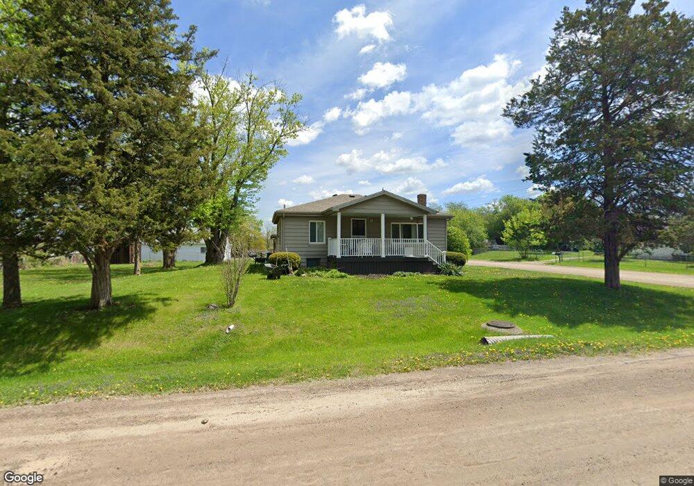
This home is located at 2119 Diamond Ave, Flint, MI 48532 and is currently estimated at $95,051, approximately $106 per square foot. 2119 Diamond Ave is a home located in Genesee County with nearby schools including Carman-Ainsworth High School, Genesee STEM Academy, and St. Paul Lutheran School.
Ownership History
Date
Name
Owned For
Owner Type
Purchase Details
Closed on
May 28, 2025
Sold by
Bell David Allan and Bell Jayne Lynn
Bought by
David And Jayne Bell Living Trust and Bell
Current Estimated Value
Purchase Details
Closed on
Sep 17, 2004
Sold by
Gmac Mortgage Corp
Bought by
Federal National Mortgage Association
Purchase Details
Closed on
Aug 18, 2004
Sold by
Smith Patricia A
Bought by
Gmac Mortgage Corp
Purchase Details
Closed on
Mar 10, 2004
Sold by
Smith Patricia A
Bought by
Gmac Mortgage Corp
Purchase Details
Closed on
Dec 29, 2000
Sold by
Rusaw Michael W and Rusaw Peggy V
Bought by
Smith Patricia A
Create a Home Valuation Report for This Property
The Home Valuation Report is an in-depth analysis detailing your home's value as well as a comparison with similar homes in the area
Home Values in the Area
Average Home Value in this Area
Purchase History
| Date | Buyer | Sale Price | Title Company |
|---|---|---|---|
| David And Jayne Bell Living Trust | -- | None Listed On Document | |
| Federal National Mortgage Association | -- | Parks Title | |
| Gmac Mortgage Corp | $118,000 | -- | |
| Gmac Mortgage Corp | $93,349 | -- | |
| Smith Patricia A | $6,000 | Metropolitan Title Company |
Source: Public Records
Tax History
| Year | Tax Paid | Tax Assessment Tax Assessment Total Assessment is a certain percentage of the fair market value that is determined by local assessors to be the total taxable value of land and additions on the property. | Land | Improvement |
|---|---|---|---|---|
| 2025 | $1,056 | $38,100 | $0 | $0 |
| 2024 | $461 | $33,600 | $0 | $0 |
| 2023 | $440 | $27,800 | $0 | $0 |
| 2022 | $534 | $25,400 | $0 | $0 |
| 2021 | $935 | $23,700 | $0 | $0 |
| 2020 | $396 | $20,300 | $0 | $0 |
| 2019 | $390 | $17,500 | $0 | $0 |
| 2018 | $897 | $20,400 | $0 | $0 |
| 2017 | $872 | $20,400 | $0 | $0 |
| 2016 | $896 | $18,300 | $0 | $0 |
| 2015 | $688 | $17,800 | $0 | $0 |
| 2014 | $408 | $17,100 | $0 | $0 |
| 2012 | -- | $20,300 | $20,300 | $0 |
Source: Public Records
Map
Nearby Homes
- 18.41 Taft Rd
- 2033 Eberly Rd
- 10 Acres T A Mansour Blvd
- 1512 Crescent Lane Dr Lot#46
- 4474 Corunna Rd
- 4480 Corunna Rd
- 1455 S Linden Rd
- 4199 Sheraton Dr
- 0 Charter Dr Unit 50153638
- 2521 White Oak Place
- 3.9 Acres W Court St
- 3277 Whitney Ave
- 4335 Lennon Rd
- 3365 Ridgecliffe Dr
- 5151 Brobeck St
- 2 Charter Dr
- 4490 W Lennon Rd
- VL Clairmont St
- 5200 Elko St
- 3088 Curtis Dr
- 2109 Diamond Ave
- 4199 Taft Rd
- 2103 Diamond Ave
- 2114 Diamond Ave
- 2104 Diamond Ave
- 2136 Monaco St
- 2132 Diamond Ave
- 2132 Monaco St
- 2096 Diamond Ave
- 2085 Diamond Ave
- 2103 Monaco St
- 2121 Dutcher St
- 2090 Diamond Ave
- 2119 Monaco St
- 2113 Monaco St Unit Bldg-Unit
- 2113 Monaco St
- 2146 Diamond Ave
- 2144 Monaco St
- 2109 Dutcher St
- 4231 Taft Rd
Your Personal Tour Guide
Ask me questions while you tour the home.