Estimated Value: $179,000 - $204,000
3
Beds
2
Baths
1,308
Sq Ft
$145/Sq Ft
Est. Value
About This Home
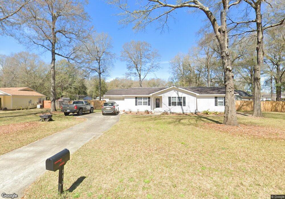
This home is located at 212 Anna's Way, Perry, GA 31069 and is currently estimated at $189,713, approximately $145 per square foot. 212 Anna's Way is a home located in Houston County with nearby schools including Langston Road Elementary School, Mossy Creek Middle School, and Perry High School.
Ownership History
Date
Name
Owned For
Owner Type
Purchase Details
Closed on
Jun 12, 2020
Sold by
Hopkins John M
Bought by
Pike Elaine K
Current Estimated Value
Home Financials for this Owner
Home Financials are based on the most recent Mortgage that was taken out on this home.
Original Mortgage
$80,000
Outstanding Balance
$70,914
Interest Rate
3.2%
Mortgage Type
New Conventional
Estimated Equity
$118,799
Purchase Details
Closed on
Nov 24, 2014
Sold by
Hopkins Catherine G
Bought by
Hopkins John M
Purchase Details
Closed on
Feb 27, 2003
Sold by
Secretary Of Veterans Affairs
Bought by
Hopkins John and Hopkins Catherine
Purchase Details
Closed on
Jul 3, 2002
Sold by
Georgia Housing & Finance Auth
Bought by
Secretary Of Veterans Affairs
Purchase Details
Closed on
Jul 2, 2002
Sold by
Knight Kenneth L
Bought by
Georgia Housing & Finance Authority
Purchase Details
Closed on
Oct 12, 1999
Sold by
La Development Inc
Bought by
Knight Kenneth L
Create a Home Valuation Report for This Property
The Home Valuation Report is an in-depth analysis detailing your home's value as well as a comparison with similar homes in the area
Home Values in the Area
Average Home Value in this Area
Purchase History
| Date | Buyer | Sale Price | Title Company |
|---|---|---|---|
| Pike Elaine K | $100,000 | None Available | |
| Hopkins John M | -- | -- | |
| Hopkins John | -- | -- | |
| Secretary Of Veterans Affairs | -- | -- | |
| Georgia Housing & Finance Authority | -- | -- | |
| Knight Kenneth L | $77,900 | -- |
Source: Public Records
Mortgage History
| Date | Status | Borrower | Loan Amount |
|---|---|---|---|
| Open | Pike Elaine K | $80,000 |
Source: Public Records
Tax History Compared to Growth
Tax History
| Year | Tax Paid | Tax Assessment Tax Assessment Total Assessment is a certain percentage of the fair market value that is determined by local assessors to be the total taxable value of land and additions on the property. | Land | Improvement |
|---|---|---|---|---|
| 2024 | $1,063 | $53,560 | $6,000 | $47,560 |
| 2023 | $862 | $44,760 | $6,000 | $38,760 |
| 2022 | $1,078 | $44,600 | $6,000 | $38,600 |
| 2021 | $934 | $38,440 | $6,000 | $32,440 |
| 2020 | $784 | $32,120 | $4,400 | $27,720 |
| 2019 | $784 | $32,120 | $4,320 | $27,800 |
| 2018 | $784 | $32,120 | $4,320 | $27,800 |
| 2017 | $785 | $32,120 | $4,320 | $27,800 |
| 2016 | $765 | $31,280 | $4,320 | $26,960 |
| 2015 | $767 | $31,280 | $4,320 | $26,960 |
| 2014 | -- | $31,280 | $4,320 | $26,960 |
| 2013 | -- | $34,440 | $7,200 | $27,240 |
Source: Public Records
Map
Nearby Homes
- 104 Arcadia Ln
- 113 Loneoak Trail
- 436 Courtney Ln
- 313 Ruger Place
- 201 Boulder Creek Rd
- 304 N Lake Dr
- 205 Canvass Back Trail
- 109 Village Blvd
- 203 Saraland Trail
- 312 Cambrian Dr
- 115 Woody Dr
- 425 Cambrian Dr
- 107 Waldorf Dr
- 431 Sawtooth Ct
- 103 Waldorf Dr
- 224 Otters Ridge Dr
- 250 Hathersage Dr
- 251 Hathersage Dr
- 0 Hunt Rd Unit 253426
- 0 Hunt Rd Unit 10529566