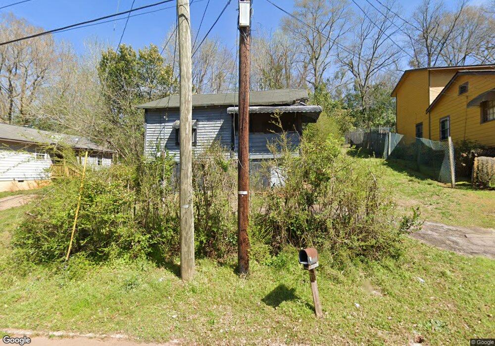
212 Banks St Lagrange, GA 30240
Estimated Value: $54,871 - $101,000
1
Bed
1
Bath
572
Sq Ft
$133/Sq Ft
Est. Value
About This Home
This home is located at 212 Banks St, Lagrange, GA 30240 and is currently estimated at $75,968, approximately $132 per square foot. 212 Banks St is a home located in Troup County with nearby schools including Franklin Forest Elementary School, Hollis Hand Elementary School, and Ethel W. Kight Elementary School.
Ownership History
Date
Name
Owned For
Owner Type
Purchase Details
Closed on
Jun 8, 1990
Sold by
Mattie Sanford and Mattie Mae Riggins
Bought by
Delaney Curry
Current Estimated Value
Purchase Details
Closed on
Jan 1, 1972
Sold by
Mattie Mae Riggins
Bought by
Mattie Sanford and Mattie Mae Riggins
Purchase Details
Closed on
Jan 1, 1969
Sold by
Bass Norman and Bass Marlene
Bought by
Mattie Mae Riggins
Purchase Details
Closed on
Jan 1, 1962
Sold by
Mrs Horace E Richter
Bought by
Bass Norman and Bass Marlene
Create a Home Valuation Report for This Property
The Home Valuation Report is an in-depth analysis detailing your home's value as well as a comparison with similar homes in the area
Home Values in the Area
Average Home Value in this Area
Purchase History
| Date | Buyer | Sale Price | Title Company |
|---|---|---|---|
| Delaney Curry | $6,000 | -- | |
| Mattie Sanford | -- | -- | |
| Mattie Mae Riggins | -- | -- | |
| Bass Norman | -- | -- |
Source: Public Records
Tax History Compared to Growth
Tax History
| Year | Tax Paid | Tax Assessment Tax Assessment Total Assessment is a certain percentage of the fair market value that is determined by local assessors to be the total taxable value of land and additions on the property. | Land | Improvement |
|---|---|---|---|---|
| 2024 | $236 | $8,640 | $720 | $7,920 |
| 2023 | $158 | $5,800 | $720 | $5,080 |
| 2022 | $154 | $5,520 | $720 | $4,800 |
| 2021 | $68 | $2,240 | $720 | $1,520 |
| 2020 | $68 | $2,240 | $720 | $1,520 |
| 2019 | $74 | $2,440 | $1,000 | $1,440 |
| 2018 | $74 | $2,440 | $1,000 | $1,440 |
| 2017 | $74 | $2,440 | $1,000 | $1,440 |
| 2016 | $87 | $2,898 | $1,000 | $1,898 |
| 2015 | $79 | $2,630 | $732 | $1,898 |
| 2014 | $77 | $2,530 | $732 | $1,798 |
| 2013 | -- | $2,669 | $732 | $1,937 |
Source: Public Records
Map
Nearby Homes
- 109 Thomas St
- 219 Banks St
- 900 North St
- 0 Ridley Ave Unit 10550104
- 609 Ridley Ave
- 707 Ridley Ave
- 611 Ridley Ave
- 615 Ridley Ave
- 709 Ridley Ave
- 110 Russell St
- 145 Turner St
- 109 Dogwood Dr
- 301 E Bacon St
- 204 Colonial St
- 806 New Franklin Rd
- 102 Ewing St
- 106 Ewing St
- 600,606,608,616 S Harlem
- 105 Saynor Cir
- 724 Camellia Dr