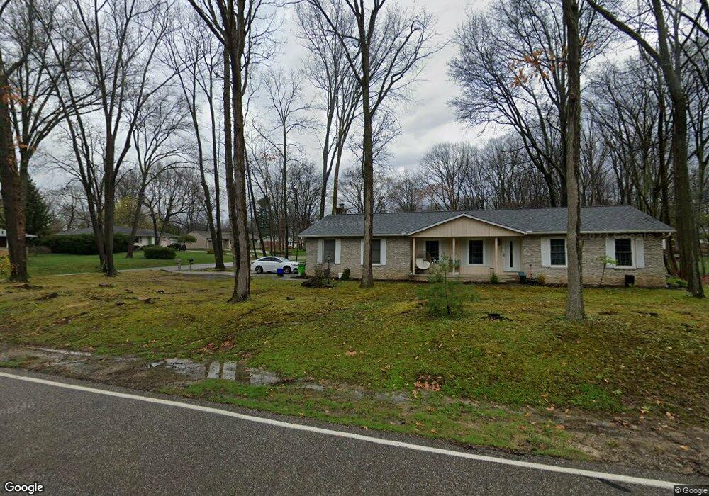
212 Barnes Dr Tallmadge, OH 44278
Estimated Value: $265,000 - $305,000
3
Beds
2
Baths
1,628
Sq Ft
$180/Sq Ft
Est. Value
About This Home
This home is located at 212 Barnes Dr, Tallmadge, OH 44278 and is currently estimated at $292,692, approximately $179 per square foot. 212 Barnes Dr is a home located in Summit County with nearby schools including Tallmadge Middle School, Tallmadge High School, and Steel Academy.
Ownership History
Date
Name
Owned For
Owner Type
Purchase Details
Closed on
Jul 28, 2023
Sold by
Livin Josephine Ellen Devaughn Revocable
Bought by
Skolnik Leslie A
Current Estimated Value
Purchase Details
Closed on
Feb 13, 2023
Sold by
Josephine Ellen Devaughn Revocable Livin and Skolnik Leslie A
Bought by
Skolnik Leslie A
Purchase Details
Closed on
Jul 8, 2005
Sold by
Devaughn Josephine Ellen
Bought by
Devaughn Josephine Ellen and Josephine Ellen Devaughn Revocable Livin
Create a Home Valuation Report for This Property
The Home Valuation Report is an in-depth analysis detailing your home's value as well as a comparison with similar homes in the area
Home Values in the Area
Average Home Value in this Area
Purchase History
| Date | Buyer | Sale Price | Title Company |
|---|---|---|---|
| Skolnik Leslie A | -- | None Listed On Document | |
| Skolnik Leslie A | -- | None Listed On Document | |
| Devaughn Josephine Ellen | -- | -- |
Source: Public Records
Tax History Compared to Growth
Tax History
| Year | Tax Paid | Tax Assessment Tax Assessment Total Assessment is a certain percentage of the fair market value that is determined by local assessors to be the total taxable value of land and additions on the property. | Land | Improvement |
|---|---|---|---|---|
| 2025 | $4,866 | $95,396 | $19,768 | $75,628 |
| 2024 | $4,866 | $95,396 | $19,768 | $75,628 |
| 2023 | $4,866 | $95,396 | $19,768 | $75,628 |
| 2022 | $3,452 | $65,338 | $13,538 | $51,800 |
| 2021 | $3,467 | $65,338 | $13,538 | $51,800 |
| 2020 | $3,440 | $65,340 | $13,540 | $51,800 |
| 2019 | $3,272 | $56,870 | $12,100 | $44,770 |
| 2018 | $2,882 | $56,870 | $12,100 | $44,770 |
| 2017 | $2,380 | $56,870 | $12,100 | $44,770 |
| 2016 | $2,567 | $48,140 | $12,100 | $36,040 |
| 2015 | $2,380 | $48,140 | $12,100 | $36,040 |
| 2014 | $2,364 | $48,140 | $12,100 | $36,040 |
| 2013 | $2,414 | $49,710 | $12,100 | $37,610 |
Source: Public Records
Map
Nearby Homes
- 617 Northeast Ave
- 557 Wring Dr
- 185 Reserve Dr
- 0 Northeast Ave Unit 5114314
- 0 East Ave
- 158 Minwood Ave
- 313 Whittlesey Dr
- 213 Green Hill Dr
- 243 S Munroe Rd
- 532 Beverly Dr
- 313 Southeast Ave
- 368 Knollwood Ave
- 353 Southeast Ave
- 1072 Carol Ln
- 288 S Munroe Rd
- 206 Fawnwood Dr
- 0 North Ave Unit 5116540
- 617 North Ave
- 528 Fernwood Ave
- 1029 Maple St