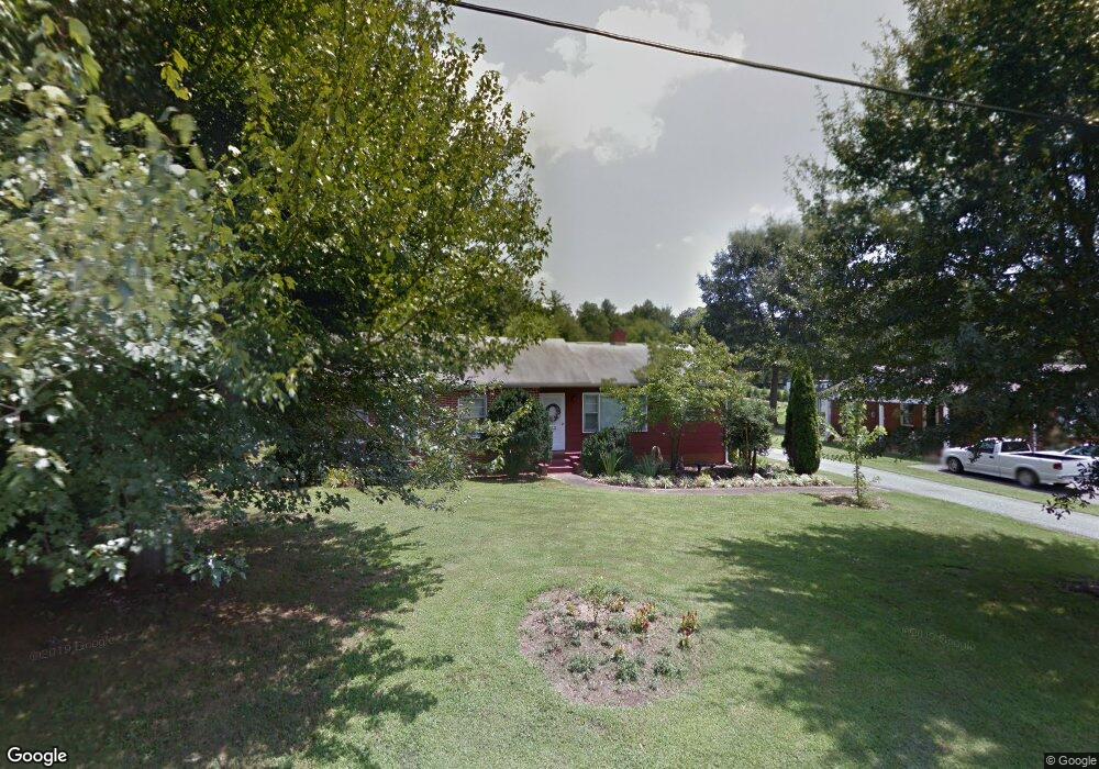
212 Glendale St Morganton, NC 28655
Estimated Value: $134,000 - $244,000
3
Beds
1
Bath
1,161
Sq Ft
$172/Sq Ft
Est. Value
About This Home
This home is located at 212 Glendale St, Morganton, NC 28655 and is currently estimated at $199,538, approximately $171 per square foot. 212 Glendale St is a home located in Burke County with nearby schools including Glen Alpine Elementary School, Table Rock Middle School, and Freedom High School.
Ownership History
Date
Name
Owned For
Owner Type
Purchase Details
Closed on
Jun 13, 2022
Sold by
Lillian Leonard
Bought by
Holden Caleb Allen and Holden Anna M
Current Estimated Value
Home Financials for this Owner
Home Financials are based on the most recent Mortgage that was taken out on this home.
Original Mortgage
$60,000
Interest Rate
5.23%
Mortgage Type
New Conventional
Purchase Details
Closed on
Apr 7, 2005
Sold by
Paschall C Lewis and Paschall Timothy T
Bought by
Leonard Philip M
Create a Home Valuation Report for This Property
The Home Valuation Report is an in-depth analysis detailing your home's value as well as a comparison with similar homes in the area
Home Values in the Area
Average Home Value in this Area
Purchase History
| Date | Buyer | Sale Price | Title Company |
|---|---|---|---|
| Holden Caleb Allen | $60,000 | Starnes Aycock Law Firm | |
| Leonard Philip M | $40,000 | None Available |
Source: Public Records
Mortgage History
| Date | Status | Borrower | Loan Amount |
|---|---|---|---|
| Previous Owner | Holden Caleb Allen | $60,000 |
Source: Public Records
Tax History Compared to Growth
Tax History
| Year | Tax Paid | Tax Assessment Tax Assessment Total Assessment is a certain percentage of the fair market value that is determined by local assessors to be the total taxable value of land and additions on the property. | Land | Improvement |
|---|---|---|---|---|
| 2025 | $807 | $127,959 | $35,015 | $92,944 |
| 2024 | $810 | $127,959 | $35,015 | $92,944 |
| 2023 | $805 | $127,959 | $35,015 | $92,944 |
| 2022 | $654 | $82,257 | $30,581 | $51,676 |
| 2021 | $648 | $82,257 | $30,581 | $51,676 |
| 2020 | $644 | $82,257 | $30,581 | $51,676 |
| 2019 | $644 | $82,257 | $30,581 | $51,676 |
| 2018 | $646 | $82,580 | $33,082 | $49,498 |
| 2017 | $644 | $82,580 | $33,082 | $49,498 |
| 2016 | $627 | $82,580 | $33,082 | $49,498 |
| 2015 | $624 | $82,580 | $33,082 | $49,498 |
| 2014 | $622 | $82,580 | $33,082 | $49,498 |
| 2013 | $622 | $82,580 | $33,082 | $49,498 |
Source: Public Records
Map
Nearby Homes
- 204 Whitley Rd
- 100 Normandy Dr
- 104 Whitley Rd
- 9999 Carbon City Rd Unit 3
- tbd Carbon City Rd Unit 2
- tbd Carbon City Rd Unit 4
- 90 Elm St
- 103 Emorywood Dr
- 826 Jamestown Rd
- 109 Highlander St
- 105 Highlander St
- 107 Highlander St
- 113 Highlander St
- 311 Mull Ln
- 1305 Carbon City Rd Unit 3
- 227 Reep Dr
- 0 Poplar Ridge Ln
- 4444 Reep Dr Unit 1
- 7777 Reep Dr Unit 3
- 8888 Reep Dr Unit 2
- 210 Glendale St
- 214 Glendale St
- 211 Glendale St
- 213 Glendale St
- 206 Glendale St
- 217 Glendale St
- 204 Glendale St
- 207 Glendale St
- 219 Glendale St
- 130 Normandy Dr
- 132 Normandy Dr
- 134 Normandy Dr
- 201 Glendale St
- 126 Normandy Dr
- 109 Glendale St
- 109 Glendale St Unit 12
- 306 Brittain Dr Unit 316
- 124 Normandy Dr
- 115 White Pine Ln
- 138 Normandy Dr