Estimated Value: $299,000 - $323,000
3
Beds
2
Baths
1,526
Sq Ft
$201/Sq Ft
Est. Value
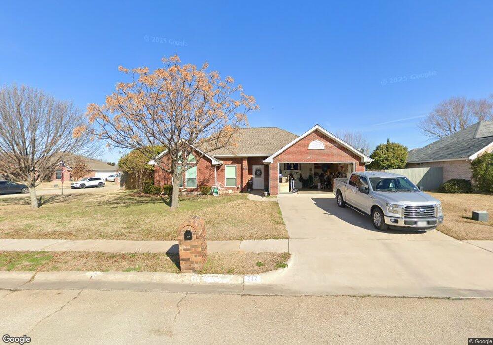
About This Home
This home is located at 212 Mourning Dove Ln, Krum, TX 76249 and is currently estimated at $307,152, approximately $201 per square foot. 212 Mourning Dove Ln is a home located in Denton County with nearby schools including Krum Early Education Center, Blanche Dodd Intermediate School, and Krum Middle School.
Ownership History
Date
Name
Owned For
Owner Type
Purchase Details
Closed on
Jan 20, 2023
Sold by
Camp Charles Perry
Bought by
Camp Living Trust
Current Estimated Value
Purchase Details
Closed on
Jun 29, 2017
Sold by
Mansell Laura and Mansell Mark
Bought by
Camp Chaeles P and Camp Judy K
Home Financials for this Owner
Home Financials are based on the most recent Mortgage that was taken out on this home.
Original Mortgage
$138,000
Interest Rate
4.02%
Mortgage Type
New Conventional
Purchase Details
Closed on
Oct 2, 2015
Sold by
Carter Candice K and Murrell Evan
Bought by
Mansell Laura and Mansell Mark
Home Financials for this Owner
Home Financials are based on the most recent Mortgage that was taken out on this home.
Original Mortgage
$151,050
Interest Rate
3.97%
Mortgage Type
New Conventional
Purchase Details
Closed on
Sep 19, 2007
Sold by
Bank Of New York
Bought by
Carter Candice K
Purchase Details
Closed on
Jun 5, 2007
Sold by
Davidson George and Gresham Geraldine
Bought by
Bank Of New York and The Certificateholders Cwabs Inc Asset B
Purchase Details
Closed on
Aug 27, 2002
Sold by
Merriman Larry W and Ross Laura S
Bought by
Davidson George and Gresham Geraldine
Home Financials for this Owner
Home Financials are based on the most recent Mortgage that was taken out on this home.
Original Mortgage
$91,200
Interest Rate
10.45%
Purchase Details
Closed on
Feb 21, 2001
Sold by
Kisko Deanna
Bought by
Merriman Larry W and Ross Laura S
Home Financials for this Owner
Home Financials are based on the most recent Mortgage that was taken out on this home.
Original Mortgage
$83,600
Interest Rate
6.97%
Purchase Details
Closed on
Jul 25, 2000
Sold by
Edmonds Investment Inc
Bought by
Kisko Deanna and Tahoe Construction
Home Financials for this Owner
Home Financials are based on the most recent Mortgage that was taken out on this home.
Original Mortgage
$86,500
Interest Rate
8.23%
Mortgage Type
Purchase Money Mortgage
Create a Home Valuation Report for This Property
The Home Valuation Report is an in-depth analysis detailing your home's value as well as a comparison with similar homes in the area
Home Values in the Area
Average Home Value in this Area
Purchase History
| Date | Buyer | Sale Price | Title Company |
|---|---|---|---|
| Camp Living Trust | -- | -- | |
| Camp Chaeles P | -- | Freedom Title | |
| Mansell Laura | -- | Title Resources | |
| Carter Candice K | -- | None Available | |
| Bank Of New York | $106,086 | None Available | |
| Davidson George | -- | -- | |
| Merriman Larry W | -- | -- | |
| Kisko Deanna | -- | -- |
Source: Public Records
Mortgage History
| Date | Status | Borrower | Loan Amount |
|---|---|---|---|
| Previous Owner | Camp Chaeles P | $138,000 | |
| Previous Owner | Mansell Laura | $151,050 | |
| Previous Owner | Davidson George | $91,200 | |
| Previous Owner | Merriman Larry W | $83,600 | |
| Previous Owner | Kisko Deanna | $86,500 | |
| Closed | Merriman Larry W | $10,450 |
Source: Public Records
Tax History Compared to Growth
Tax History
| Year | Tax Paid | Tax Assessment Tax Assessment Total Assessment is a certain percentage of the fair market value that is determined by local assessors to be the total taxable value of land and additions on the property. | Land | Improvement |
|---|---|---|---|---|
| 2025 | $3,080 | $282,377 | $57,038 | $225,339 |
| 2024 | $5,673 | $281,502 | $57,038 | $224,464 |
| 2023 | $2,992 | $266,200 | $57,038 | $220,962 |
| 2022 | $5,551 | $242,000 | $57,038 | $208,213 |
| 2021 | $4,548 | $205,090 | $38,303 | $166,787 |
| 2020 | $4,982 | $219,992 | $42,559 | $177,433 |
| 2019 | $4,949 | $205,095 | $42,559 | $174,692 |
| 2018 | $4,522 | $186,450 | $35,100 | $151,350 |
| 2017 | $3,979 | $163,337 | $24,833 | $138,504 |
| 2016 | $3,576 | $162,009 | $24,833 | $137,176 |
| 2015 | $2,901 | $133,236 | $24,833 | $108,403 |
| 2014 | $2,901 | $127,324 | $24,833 | $102,491 |
| 2013 | -- | $120,470 | $24,833 | $95,637 |
Source: Public Records
Map
Nearby Homes
- 210 Mourning Dove Ln
- 213 White Wing Dr
- 119 N Point Dr
- 117 N Point Dr
- 211 White Wing Dr
- 208 Mourning Dove Ln
- 213 Mourning Dove Ln
- 215 Mourning Dove Ln
- 121 N Point Dr
- 115 N Point Dr
- 211 Mourning Dove Ln
- 209 White Wing Dr
- 113 N Point Dr
- 123 N Point Dr
- 206 Mourning Dove Ln
- 209 Mourning Dove Ln
- 210 White Wing Dr
- 214 Dove Meadows
- 216 Dove Meadows
- 125 N Point Dr